
 |
2nd Light Forums |
 |
 |  |


|
Topic Title: Dorian named. Tracking interesting. Topic Summary: May get sheared by the island mountains. Created On: 08/25/2019 11:41 AM |
Linear : Threading : Single : Branch |
 |
- Central Floridave | - 08/25/2019 11:41 AM |
|
- dingpatch | - 08/25/2019 04:28 PM |
|
- Central Floridave | - 08/27/2019 03:35 AM |
|
- dingpatch | - 08/27/2019 05:31 AM |
|
- Central Floridave | - 08/27/2019 07:04 AM |
|
- scombrid | - 08/27/2019 07:14 AM |
|
- Plan B | - 08/27/2019 07:23 AM |
|
- pompano | - 08/27/2019 06:29 PM |
|
- Central Floridave | - 08/28/2019 03:53 AM |
|
- Central Floridave | - 08/28/2019 03:56 AM |
|
- Central Floridave | - 08/28/2019 04:24 AM |
|
- dingpatch | - 08/28/2019 04:33 AM |
|
- Central Floridave | - 08/28/2019 04:46 AM |
|
- Plan B | - 08/28/2019 04:58 AM |
|
- Plan B | - 08/28/2019 05:00 AM |
|
- dingpatch | - 08/28/2019 05:06 AM |
|
- Plan B | - 08/28/2019 06:05 AM |
|
- Plan B | - 08/28/2019 07:11 AM |
|
- paddleout | - 08/28/2019 08:16 AM |
|
- Plan B | - 08/28/2019 08:20 AM |
|
- Central Floridave | - 08/28/2019 08:21 AM |
|
- Central Floridave | - 08/28/2019 08:24 AM |
|
- harrietdubman | - 08/28/2019 08:59 AM |
|
- Central Floridave | - 08/28/2019 09:17 AM |
|
- Central Floridave | - 08/28/2019 09:18 AM |
|
- Central Floridave | - 08/28/2019 09:19 AM |
|
- palmtreeg | - 08/28/2019 09:38 AM |
|
- KP | - 08/28/2019 10:18 AM |
|
- seaspray | - 08/28/2019 10:24 AM |
|
- paddleout | - 08/28/2019 10:51 AM |
|
- 3rdworldlover | - 08/28/2019 11:40 AM |
|
- dingpatch | - 08/28/2019 11:57 AM |
|
- dingpatch | - 08/28/2019 12:29 PM |
|
- paddleout | - 08/28/2019 12:53 PM |
|
- paddleout | - 08/28/2019 01:13 PM |
|
- dingpatch | - 08/28/2019 01:20 PM |
|
- Plan B | - 08/28/2019 01:34 PM |
|
- dingpatch | - 08/28/2019 01:38 PM |
|
- Plan B | - 08/28/2019 02:03 PM |
|
- Central Floridave | - 08/29/2019 03:45 AM |
|
- dingpatch | - 08/29/2019 05:08 AM |
|
- Plan B | - 08/29/2019 05:24 AM |
|
- dingpatch | - 08/29/2019 05:30 AM |
|
- Greensleeves | - 08/29/2019 05:33 AM |
|
- seaspray | - 08/29/2019 05:53 AM |
|
- dingpatch | - 08/29/2019 06:26 AM |
|
- johnnyboy | - 08/29/2019 06:28 AM |
|
- worksuxgetsponsered | - 08/29/2019 12:00 PM |
|
- paddleout | - 08/31/2019 05:49 AM |
|
- rc | - 08/31/2019 06:07 AM |
|
- bluestreak | - 08/31/2019 06:15 AM |
|
- Central Floridave | - 08/29/2019 06:48 AM |
|
- StirfryMcflurry | - 09/10/2019 10:16 AM |
|
- paddleout | - 08/29/2019 07:01 AM |
|
- paddleout | - 08/29/2019 09:05 AM |
|
- Central Floridave | - 08/29/2019 09:32 AM |
|
- johnnyboy | - 08/29/2019 09:55 AM |
|
- Cole | - 08/29/2019 10:31 AM |
|
- scostuart | - 08/29/2019 10:52 AM |
|
- dingpatch | - 08/29/2019 11:10 AM |
|
- Central Floridave | - 08/29/2019 11:50 AM |
|
- paddleout | - 08/29/2019 11:55 AM |
|
- SRPHOTO | - 08/29/2019 12:01 PM |
|
- worksuxgetsponsered | - 08/29/2019 12:04 PM |
|
- saltydog73 | - 08/29/2019 12:31 PM |
|
- SRPHOTO | - 08/29/2019 12:41 PM |
|
- Plan B | - 08/29/2019 12:42 PM |
|
- dingpatch | - 08/29/2019 02:32 PM |
|
- GREG | - 08/29/2019 07:16 PM |
|
- paddleout | - 08/29/2019 08:31 PM |
|
- SurferMic | - 08/30/2019 05:24 AM |
|
- dingpatch | - 08/30/2019 06:16 AM |
|
- daner | - 08/30/2019 07:11 AM |
|
- garcia | - 08/30/2019 07:19 AM |
|
- dingpatch | - 08/30/2019 07:20 AM |
|
- dingpatch | - 08/30/2019 08:52 AM |
|
- paddleout | - 08/30/2019 09:22 AM |
|
- Greensleeves | - 08/30/2019 09:42 AM |
|
- Cole | - 08/30/2019 10:28 AM |
|
- dingpatch | - 08/30/2019 10:44 AM |
|
- Karma | - 08/30/2019 10:36 AM |
|
- harrietdubman | - 08/30/2019 10:45 AM |
|
- Seth | - 08/30/2019 10:51 AM |
|
- RiddleMe | - 08/30/2019 11:07 AM |
|
- Karma | - 08/30/2019 11:08 AM |
|
- harrietdubman | - 08/30/2019 11:21 AM |
|
- dingpatch | - 08/30/2019 12:27 PM |
|
- dingpatch | - 08/30/2019 02:00 PM |
|
- dingpatch | - 08/30/2019 02:06 PM |
|
- StirfryMcflurry | - 08/30/2019 02:07 PM |
|
- garcia | - 08/30/2019 02:09 PM |
|
- dingpatch | - 08/30/2019 02:18 PM |
|
- dingpatch | - 08/30/2019 02:24 PM |
|
- Cole | - 08/30/2019 02:37 PM |
|
- paddleout | - 08/30/2019 02:07 PM |
|
- paddleout | - 08/30/2019 04:43 PM |
|
- paddleout | - 08/30/2019 04:47 PM |
|
- paddleout | - 08/30/2019 08:26 PM |
|
- TONYlookaround | - 08/30/2019 09:24 PM |
|
- paddleout | - 08/31/2019 05:27 AM |
|
- garcia | - 08/31/2019 05:36 AM |
|
- Central Floridave | - 08/31/2019 05:34 AM |
|
- Greensleeves | - 08/31/2019 06:31 AM |
|
- chopola | - 08/31/2019 06:45 AM |
|
- paddleout | - 08/31/2019 07:08 AM |
|
- dingpatch | - 08/31/2019 07:38 AM |
|
- 3rdworldlover | - 08/31/2019 08:01 AM |
|
- paddleout | - 08/31/2019 08:08 AM |
|
- palmtreeg | - 08/31/2019 09:15 AM |
|
- dingpatch | - 08/31/2019 09:23 AM |
|
- chopola | - 08/31/2019 11:06 AM |
|
- K07 | - 08/31/2019 11:15 AM |
|
- Central Floridave | - 08/31/2019 11:47 AM |
|
- harrietdubman | - 08/31/2019 01:06 PM |
|
- seaspray | - 08/31/2019 01:46 PM |
|
- dingpatch | - 08/31/2019 05:07 PM |
|
- paddleout | - 08/31/2019 06:25 PM |
|
- pumphouse | - 08/31/2019 06:30 PM |
|
- paddleout | - 08/31/2019 07:58 PM |
|
- RiddleMe | - 08/31/2019 09:08 PM |
|
- paddleout | - 08/31/2019 09:23 PM |
|
- 3rdworldlover | - 08/31/2019 09:36 PM |
|
- RiddleMe | - 09/01/2019 03:37 AM |
|
- dingpatch | - 09/01/2019 04:30 AM |
|
- MSP | - 09/01/2019 04:36 AM |
|
- pumphouse | - 09/01/2019 04:48 AM |
|
- tom | - 09/01/2019 04:59 AM |
|
- RiddleMe | - 09/01/2019 05:02 AM |
|
- Central Floridave | - 09/01/2019 05:07 AM |
|
- RiddleMe | - 09/01/2019 06:45 AM |
|
- paddleout | - 09/01/2019 07:10 AM |
|
- Plan B | - 09/01/2019 07:55 AM |
|
- Central Floridave | - 09/01/2019 07:59 AM |
|
- Central Floridave | - 09/01/2019 08:00 AM |
|
- Plan B | - 09/01/2019 08:01 AM |
|
- paddleout | - 09/01/2019 08:09 AM |
|
- chopola | - 09/01/2019 08:22 AM |
|
- dingpatch | - 09/01/2019 08:37 AM |
|
- paddleout | - 09/01/2019 09:05 AM |
|
- dingpatch | - 09/01/2019 09:09 AM |
|
- Central Floridave | - 09/01/2019 09:20 AM |
|
- Central Floridave | - 09/01/2019 09:36 AM |
|
- Central Floridave | - 09/01/2019 09:39 AM |
|
- tom | - 09/01/2019 09:56 AM |
|
- RiddleMe | - 09/01/2019 09:59 AM |
|
- SunriseSurfer | - 09/01/2019 11:43 AM |
|
- Central Floridave | - 09/01/2019 12:12 PM |
|
- Central Floridave | - 09/01/2019 12:12 PM |
|
- Central Floridave | - 09/01/2019 12:29 PM |
|
- Central Floridave | - 09/01/2019 12:44 PM |
|
- dingpatch | - 09/01/2019 02:51 PM |
|
- pumphouse | - 09/01/2019 06:52 PM |
|
- Plan B | - 09/01/2019 08:20 PM |
|
- K07 | - 09/01/2019 09:25 PM |
|
- Central Floridave | - 09/02/2019 03:51 AM |
|
- dingpatch | - 09/02/2019 05:28 AM |
|
- dingpatch | - 09/02/2019 07:10 AM |
|
- Cole | - 09/02/2019 12:59 PM |
|
- Greensleeves | - 09/02/2019 02:06 PM |
|
- surfmcc32 | - 09/02/2019 02:29 PM |
|
- Cole | - 09/02/2019 02:36 PM |
|
- paddleout | - 09/02/2019 08:11 AM |
|
- pumphouse | - 09/02/2019 12:18 PM |
|
- Central Floridave | - 09/02/2019 03:30 PM |
|
- RocketSurf | - 09/02/2019 04:06 PM |
|
- HAPDigital | - 09/03/2019 06:01 AM |
|
- Plan B | - 09/03/2019 06:05 AM |
|
- Central Floridave | - 09/03/2019 05:36 AM |
|
- Central Floridave | - 09/03/2019 12:21 PM |
|
- Central Floridave | - 09/03/2019 12:24 PM |
|
- Central Floridave | - 09/03/2019 12:27 PM |
|
- daner | - 09/03/2019 03:47 PM |
|
- paddleout | - 09/03/2019 03:53 PM |
|
- Long Beard | - 09/03/2019 04:12 PM |
|
- Central Floridave | - 09/03/2019 04:39 PM |
|
- seaspray | - 09/03/2019 04:49 PM |
|
- rc | - 09/03/2019 05:14 PM |
|
- ww | - 09/03/2019 06:01 PM |
|
- pumphouse | - 09/03/2019 04:52 PM |
|
- SpinK | - 09/03/2019 06:03 PM |
|
- RiddleMe | - 09/03/2019 06:09 PM |
|
- Central Floridave | - 09/05/2019 05:47 AM |
|
- dingpatch | - 09/05/2019 06:38 AM |
|
- scostuart | - 09/10/2019 11:41 AM |
|
- camguy | - 09/10/2019 01:08 PM |
|
- dingpatch | - 09/10/2019 03:01 PM |
|
- Central Floridave | - 09/05/2019 07:38 AM |
|
- Central Floridave | - 09/05/2019 07:43 AM |
|
- paddleout | - 09/10/2019 06:44 PM |
 Topic Tools Topic Tools
|

 08/25/2019 11:41 AM 08/25/2019 11:41 AM


|
|
|
EDIT: took out old NHC forecast
Edited: 08/28/2019 at 04:47 AM by Central Floridave |
|
|
|
|
|
08/25/2019 04:28 PM
|
|

------------------------- Dora Hates You |
|
|
|
|
|
08/27/2019 03:35 AM
|
|
|
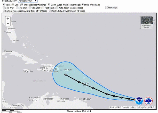
Tropical Storm Dorian Discussion Number 12
NWS National Hurricane Center Miami FL AL052019 500 AM AST Tue Aug 27 2019 Dorian passed over Barbados a few hours ago and it is now very near the Windward Islands. Data from the Air Force Hurricane Hunters earlier this morning suggest that the storm has held steady in intensity with a blend of the flight level and SFMR winds supporting a wind speed of 45 kt. The Caribbean composite radar data show that Dorian remains a very compact system and that it still lacks a well-defined inner core. Dry air in the mid-levels of the atmosphere around Dorian has been causing the storm to remain in a fairly steady state during the past day or so despite relatively low wind shear conditions and warm SSTs. The models show this dry air persisting in the vicinity of the system while it tracks across the Caribbean during the next day or two, so it seems likely that Dorian will continue to only gradually intensify during that time. When Dorian nears Hispaniola in 36 to 48 hours, there will likely be some increase in wind shear and those less favorable winds aloft and the interaction with the landmasses of Puerto Rico and Hispaniola should cause considerable weakening. Once the system moves north of the Greater Antilles, the environmental conditions become more favorable for intensification, and most of the intensity guidance responds by showing an increase in winds. However, there remains considerable uncertainty for this part of the forecast because the future intensity of Dorian will be quite dependent on how much land interaction there is with the mountainous island of Hispaniola. The NHC intensity forecast lies near the upper end of the guidance in the short term, while the system is over the Caribbean Sea, but near the middle of the guidance envelope after that. The storm is moving west-northwestward at 11 kt steered by a subtropical ridge to the north. This general motion should continue for another 12 to 24 hours taking Dorian across the eastern Caribbean Sea. After that time, a slight turn to the northwest is likely when the cyclone nears the eastern portion of a cut off mid- to upper-level low and moves toward a weakness in the ridge. This should take Dorian across the Dominican Republic and the Mona Passage and over the Bahamas in the 3 to 4 day time period. A ridge is likely to rebuild to the north of Dorian when it is forecast to be over the Bahamas and that could cause it to turn slightly to the left by the end of the forecast period. The new NHC track forecast is largely unchanged while Dorian is in the Caribbean, but it has been shifted slightly to the north thereafter. Users are reminded not to focus on the details of the extended track forecast as the average 5-day track error is around 200 miles. Key Messages: 1. Dorian is expected to bring tropical storm conditions to portions of the Lesser Antilles during the next several hours, where tropical storm watches and warnings are in effect. Rainfall of 3 to 6 inches is expected from Martinique to St. Vincent with isolated totals as high as 10 inches possible. 2. Tropical storm conditions are expected and hurricane conditions are possible in Puerto Rico on Wednesday, where a tropical storm warning and hurricane watch have been issued. Rainfall of 2 to 4 inches with maximum totals of 6 inches are possible across Puerto Rico and St. Croix. 3. Hurricane and Tropical Storm Watches have been issued for portions of the Dominican Republic. 4. While uncertainty remains high, wind and rain impacts are possible in the Bahamas and Florida later this week and this weekend. Residents in these areas should monitor the progress of Dorian and ensure that they have their hurricane plan in place. FORECAST POSITIONS AND MAX WINDS INIT 27/0900Z 13.5N 60.7W 45 KT 50 MPH 12H 27/1800Z 14.4N 62.3W 50 KT 60 MPH 24H 28/0600Z 15.7N 64.5W 55 KT 65 MPH 36H 28/1800Z 17.0N 66.5W 60 KT 70 MPH 48H 29/0600Z 18.5N 68.2W 60 KT 70 MPH 72H 30/0600Z 21.7N 71.4W 50 KT 60 MPH 96H 31/0600Z 24.7N 75.1W 60 KT 70 MPH 120H 01/0600Z 27.1N 79.6W 60 KT 70 MPH |
|
|
|
|
|
08/27/2019 05:31 AM
|
|
|
CFL Hurricane Dorian Lounge
And, better put your Depends on before you read this, , , , , Morning model roundup either 6z or 0z depending on the model: 6Z GFS:: Cuts over Hispaniola Thursday, clear of the Caribbean Thursday evening. Starts getting reorganized over the Central Bahamas on Saturday morning. Melbourne Landfall Sunday morning, Strong Tropical Storm. Does not reenter Gulf. 0Z Euro Clips eastern edge of Hispaniola midday Thursday, clear by the evening. Melbourne Landfall Sunday afternoon, Strong Tropical Storm. Does not reenter Gulf. 6z Legacy GFS - Landfall Puerto Rico late Wednesday afternoon, Clears the Caribbean overnight into Thursday. Strengthens to Hurricane just NE of the Turks and Caicos Thursday night. Cat 2 hurricane over Great Abaco island in the Bahamas Saturday afternoon. Landfall Melbourne, FL midday Sunday as a strong Cat 2 hurricane. Does not reenter Gulf. 0z CMC - slips through Mona passage Thursday morning, Cat 1 hurricane near Great Abaco midday Saturday. Landfall near Ft. Pierce Sunday morning as a cat 1/2 hurricane. Enters Gulf just north of Tampa late Sunday night, weak cat 1/strong TS another landfall near Carabelle, FL late Monday night. 0z NAVGEM - Clips Western side of Puerto Rico as a TS, landfall Cat 2 hurricane near Ft. Lauderdale late Sunday night. Exits into the Gulf near Sarasota by Monday night. Run ends there in the Gulf as a Cat 1. 0z Icon takes it over the eastern side of PR as a tropical Storm. Then dives it back into Cuba, end of run is a cat 1 between the Yucatan and Cuba. The 6z run of the same model keeps it in the Central Bahamas, but the run ends there. 0z HWRF takes it right over Hispaniola, it eventually recovers near the NW Bahamas, landfall strong TS/Cat 1 hurricane Melbourne, FL late Saturday night into Sunday morning. Run ends over Orlando. 0z HMON Takes it way west toward the Tiburon Peninsula of Haiti, then winds up with a strong TS/Cat 1 hurricane southwest of Andros island. 0z UKMET Takes Dorian as a Tropical Storm over the eastern side of Puerto Rico Wednesday evening. Forms into a Cat 2 hurricane near Cat Island in the Bahamas, Landfall Cat 2 hurricane near Ft. Lauderdale late Sunday night. Run ends just east of Ft. Myers inland. experimental HALFs morning run, strengthens the system east of the Bahamas, approaches E. Central Florida Monday where it explodes into a cat 4 almost 5 hurricane where the run ends east of Melbourne. ------------------------- Dora Hates You |
|
|
|
|
|
08/27/2019 07:04 AM
|
|
|
Check storm surf virtual buoy for Sept 1. Spikes to 13 feet for one day then gone. That is a direct strike.
http://stormsurf.com/cgi-bin/4cast.cgi?ID=wna.41009 |
|
|
|
|
|
08/27/2019 07:14 AM
|
|
|
That is based on the most recent GFS run.
------------------------- ... |
|
|
|
|
|
08/27/2019 07:23 AM
|
|
|
Last EURO run was in agreement with that as well..... most others are close, but with a more intense storm.
|
|
|
|
|
|
08/27/2019 06:29 PM
|
|
|
The track that skirts it through the islands and north over open water and then loop around the Bahama Bank definitely has the greatest chance to gain lots of strength due to deep, warm water. And I just had my shingles replaced, so my guess is they are not really stuck together and may just come off in chunks if it really does strengthen like they mention. sigh.
|
|
|
|
|
|
08/28/2019 03:53 AM
|
|
|
Tropical Storm Dorian Discussion Number 16
NWS National Hurricane Center Miami FL AL052019 500 AM AST Wed Aug 28 2019 Satellite images and Doppler radar data from Puerto Rico indicate that Dorian is becoming better organized with banding features now more established on the north side of the circulation. The flight-level and SFMR winds from the Air Force Hurricane Hunters were a little higher in the most recent passes through the storm, and a blend of that data supports an initial intensity of about 50 kt. The Hurricane Hunters also reported that Dorian has developed a partial eyewall and that the minimum pressure has dropped to 1003 mb. A combination of the reconnaissance data and recent ASCAT passes were used to modify the initial wind radii, and it confirms that Dorian remains a compact and asymmetric tropical storm. Dorian is moving northwestward at 11 kt toward a weakness in the ridge caused by a cut off mid- to upper-level low to the north of Hispaniola. This motion should continue for the next few days, taking Dorian across the Virgin Islands or the eastern portion of Puerto Rico later today and to the east of the Bahamas on Thursday and Friday. By late in the week, the steering pattern is expected to change as the models show a ridge building over the western Atlantic. The flow between the ridge and the aforementioned mid- to upper-level low should cause Dorian to turn west-northwestward and approach the southeast U.S. coast this weekend. The new NHC track forecast is adjusted a little to the right at most forecast times trending toward the latest consensus aids. However, there has been considerable run-to-run variability among the models so confidence in the long term track remains low. In addition, users are reminded not to focus on the exact forecast points as the average 5-day track error is around 200 miles. Some additional slow strengthening seems likely today before Dorian reaches Puerto Rico and the Virgin Islands. The land interaction could end the strengthening trend or even cause some temporary weakening, however, environmental conditions favor intensification after the storm pulls northward into the southwestern Atlantic. Nearly all of the intensity models show Dorian becoming a hurricane in about 2 days, with additional strengthening beyond that time. The NHC intensity forecast is increased from the previous one, especially at the longer forecast times, to be in better agreement with the latest models. This forecast, however, is still on the lower end of the guidance envelope, so additional upward adjustments could be needed if the guidance trends persists. It is also worth noting that the global models show Dorian increasing in size by the time it nears the southeast U.S. Key Messages: 1. Tropical storm conditions are expected in the U.S. and British Virgin Islands and Puerto Rico today, and are possible in portions of the Dominican Republic tonight and Thursday. Hurricane conditions are possible in Puerto Rico and the U.S. Virgin Islands today. 2. Heavy rainfall over portions of Puerto Rico and the U.S. and British Virgin Islands could produce flash flooding during the next couple of days. Heavy rains are expected to occur over portions of the Bahamas and Florida later this week and into early next week. 3. The threat of tropical storm or hurricane conditions, along with storm surge, in the northwestern Bahamas and along portions of the Florida east coast have increased. Residents in these areas should monitor the progress of Dorian and ensure that they have their hurricane plan in place. 4. Uncertainty in the intensity forecast late this week remains higher than usual due to a large spread in the model guidance. FORECAST POSITIONS AND MAX WINDS INIT 28/0900Z 16.8N 63.9W 50 KT 60 MPH 12H 28/1800Z 17.9N 65.3W 60 KT 70 MPH 24H 29/0600Z 19.5N 66.8W 60 KT 70 MPH 36H 29/1800Z 21.4N 68.2W 60 KT 70 MPH 48H 30/0600Z 23.3N 69.6W 65 KT 75 MPH 72H 31/0600Z 26.1N 73.0W 80 KT 90 MPH 96H 01/0600Z 27.7N 77.1W 85 KT 100 MPH 120H 02/0600Z 29.0N 80.0W 85 KT 100 MPH |
|
|
|
|
|
08/28/2019 03:56 AM
|
|
|
Tuesday afternoon model runs were trending to recurve near the Florida coast. NHC update has Dorian at 120hours off the coast of Daytona.
|
|
|
|
|
|
08/28/2019 04:24 AM
|
|
|
Gotta like what those long range models are showing this Wednesday AM. Showing to recurve and hit North Carolina.
|
|
|
|
|
|
08/28/2019 04:33 AM
|
|

------------------------- Dora Hates You |
|
|
|
|
|
08/28/2019 04:46 AM
|
|
|
Woot! Hope that recurve happens. Check the virtual buoy models, especially magic seaweeed. potential to be really good surf coming! Dorian, go visit Bermuda and leave us alone!
|
|
|
|
|
|
08/28/2019 04:58 AM
|
|
|
FUUUUUUUCK.....

|
|
|
|
|
|
08/28/2019 05:00 AM
|
|
 HWRF, not the best for track forcast but good with intensity
|
|
|
|
|
|
08/28/2019 05:06 AM
|
|
|
But now, after all of this back-and-forth, watch this thing get East of the Bahamas, then have the high pressure ridge really build in, and then have Dorian take a hard left into Miami as a CAT 4 with only 24 hours warning. Who does Dade County sue?
------------------------- Dora Hates You |
|
|
|
|
|
08/28/2019 06:05 AM
|
|
|
This isnt good:
|
|
|
|
|
|
08/28/2019 07:11 AM
|
|
|
growing:
|
|
|
|
|
|
08/28/2019 08:16 AM
|
|
|
Jesus.. 11am update has it pointed right at us as a MAJOR HURRICANE |
|
|
|
|
|
08/28/2019 08:20 AM
|
|
|
If you live by the water, and cant manage some serious flood control..... GORILLA TAPE is your friend. I'm going to get some now. ZIP tape is good too (prob better)... but it will make a mess of things when its time to remove
Edited: 08/28/2019 at 08:20 AM by Plan B |
|
|
|
|
|
08/28/2019 08:21 AM
|
|
|
Wed 11pm update
FORECAST POSITIONS AND MAX WINDS INIT 28/1500Z 17.5N 64.5W 60 KT 70 MPH 12H 29/0000Z 18.7N 65.7W 65 KT 75 MPH 24H 29/1200Z 20.5N 67.0W 65 KT 75 MPH 36H 30/0000Z 22.4N 68.4W 70 KT 80 MPH 48H 30/1200Z 24.2N 69.9W 75 KT 85 MPH 72H 31/1200Z 26.5N 74.0W 90 KT 105 MPH 96H 01/1200Z 27.7N 77.7W 100 KT 115 MPH 120H 02/1200Z 28.6N 80.3W 100 KT 115 MPH |
|
|
|
|
|
08/28/2019 08:24 AM
|
|
|
28.6N 80.3W is right off of Cape Canaveral early Monday.
Someone tell the models to recurve this thing again! Come ON 12Zulu updates....RECURVE RECURVE RECURVE.... |
|
|
|
|
|
08/28/2019 08:59 AM
|
|
|
f()ck NHC but more importantly, f()ck current a$$hole in charge for cutting funding. these people really have no clue regarding forecasting. they measure data real time and give it to you, that's about it. i dont need to tell most of you but going from tropical storm to major hurricane in under twelve hours is hard to accept...prepare for the worst, hope for the best.
------------------------- sneedeker Edited: 08/28/2019 at 09:01 AM by harrietdubman |
|
|
|
|
|
08/28/2019 09:17 AM
|
|
|
Maybe Home Depot gave NHC some money to up the forecast!
Sales were slow with just a cat 1 forecast. Cat 3 gets people attentions better. Could be true. NHC just sent out a tweet to prepare now. |
|
|
|
|
|
08/28/2019 09:18 AM
|
|
|
|
|
|
|
|
08/28/2019 09:19 AM
|
|
|
|
|
|
08/28/2019 09:38 AM
|
|
|
Latest update has it hitting FL as a Major Hurricane
Waves should be good though ------------------------- Brevard Surf Report |
|
|
|
|
|
08/28/2019 10:18 AM
|
|
|
Latest update has it hitting FL as a Major Hurricane Waves should be good though Lol I was thinking the same! ------------------------- Time and tide wait for no one..... |
|
|
|
|
|
08/28/2019 10:24 AM
|
|
|
Cat 2 (or 3) beeline right for us, Friday and Saturday gonna be yuuuuge
Surf some before you take care of your home and family I'm still certain this thing will make some last minute turn Edited: 08/28/2019 at 10:24 AM by seaspray |
|
|
|
|
|
08/28/2019 10:51 AM
|
|
|
The surf and wind will be crap- always is. |
|
|
|
|
|
08/28/2019 11:40 AM
|
|
|
Latest GFS and Euro runs have SFL and then Panhandle getting hammered by a major.
Seems the more likely track, based on climatology. Crap |
|
|
|
|
|
08/28/2019 11:57 AM
|
|
|
A 1:59 note from a weather analyst: (I've added some Emphasis)
"I just spent a half hour looking at the western ATL sat loops which presented the picture of the complex situation ahead of Doreen. . ..There is a weak ULL feature to its NW and it is being influenced by the flow around that feature. Ahead of that feature is a NW-SE flow which then becomes westerly over the FL Straits. The ULL is not strong and its influence on Doreen seems to be lessening. If so the NW track currently being seen should become more WNW..fairly soon. In the CONUS: NW of Florida a trough is pushing SE-E toward exiting CONUS probably in a day or two. By then Doreen should be in the lower Bahamas where a more traditional SE-NW flow should be evident.. A generally easterly flow seems to be following across the ATL behind all this. And if it becomes more of an influence it could be the cause for Doreen to take a more westerly path. I think this complex situation will begin to be come more clear by tomorrow." ------------------------- Dora Hates You Edited: 08/28/2019 at 12:14 PM by dingpatch |
|
|
|
|
|
08/28/2019 12:29 PM
|
|

------------------------- Dora Hates You |
|
|
|
|
|
08/28/2019 12:53 PM
|
|
|
Since the name of the storm is DORIAN and not DOREEN, I woulnt hold that analyst's input in the highest regard: p |
|
|
|
|
|
08/28/2019 01:13 PM
|
|
|
PLAN B speaking of tape, try that NO RESIDUE duct tape by 3M (I think)
its like a dark silver color- a little bit more expensive but strong as hell AND a breeze to remive with no mess they have it at lowes and i think even publix |
|
|
|
|
|
08/28/2019 01:20 PM
|
|
|
Ummmm, , , , , ahhhhh, , , , , am I missing something? Tape? What is tape going to do for you in at CAT 4?
------------------------- Dora Hates You |
|
|
|
|
|
08/28/2019 01:34 PM
|
|
|
Edited: 08/28/2019 at 01:35 PM by Plan B |
|
|
|
|
|
08/28/2019 01:38 PM
|
|
|
I get it!! Good luck, if comes to the point that you, me, we need it!!!
------------------------- Dora Hates You |
|
|
|
|
|
08/28/2019 02:03 PM
|
|
|
Can someone merge these threads? in the meantime.... REALLY BAD:
|
|
|
|
|
|
08/29/2019 03:45 AM
|
|
|
Hurricane Dorian Discussion Number 20
NWS National Hurricane Center Miami FL AL052019 500 AM AST Thu Aug 29 2019 Soon after the previous advisory was issued, Dorian appeared to have a bit of a hiccup in its structure. A dry slot was noted penetrating into the southeastern portion of the circulation, with the eye becoming cloud- and rain-filled. In fact, dropsonde data from the Air Force Reserve mission indicated that the central pressure had come back up a bit to around 991 mb. That being said, the plane still measured maximum SFMR winds between 70-75 kt, so the initial intensity is being held steady at 75 kt for this advisory. Dorian continues northwestward, or 325 degrees at 11 kt. Confidence in the track forecast is fairly high for the first 48 hours, with Dorian expected to continue moving northwestward and then begin to turn west-northwestward between mid-level ridging to the north and a mid- to upper-level low retrograding westward across the Straits of Florida. The models, and their ensembles, continue to diverge after 48 hours and have not really budged from their respective solutions compared to yesterday. The GFS is a northern outlier from the rest of the guidance, showing a weaker ridge and bringing Dorian close to the Florida/Georgia border, while the UKMET and ECMWF models show stronger ridges and remain the southernmost solutions near South Florida. Given the spread in the guidance, the new NHC forecast blends the previous forecast with the simple multi-model consensus aids and the HCCA and Florida State Superensemble aids, and it actually ends up in a position very close to the tightly clustered global model ensemble means. The most notable change in the new forecast is that it's a little bit slower than the previous one as Dorian approaches Florida. Various shear analyses are indicating 10-15 kt of southwesterly shear over Dorian at the moment, but the global models show this shear diminishing within 12-24 hours. With lower shear and very warm waters, all of the intensity models forecast Dorian to begin strengthening again soon, and rapid intensification could occur. The updated NHC intensity forecast has been increased from the previous one and most closely follows the HCCA and Florida State Superensemble aids during the first day or two. After 48 hours, the official forecast is near or just above the intensity consensus, but it's still lower than the solutions shown by the HCCA, Florida State Superensemble, and the HWRF. Dorian is likely to reach major hurricane strength in the next day or two and is forecast to maintain that status until it reaches land. Key Messages: 1. The risk of dangerous storm surge and hurricane-force winds later this week and this weekend continues to increase in the central and northwestern Bahamas and along the Florida east coast, although it is too soon to determine where these hazards will occur. Residents in these areas should ensure they have their hurricane plan in place and not focus on the exact forecast track of Dorian's center. 2. Heavy rains are expected to occur over portions of the Bahamas, Florida, and elsewhere in the southeastern United States later this week and into early next week. FORECAST POSITIONS AND MAX WINDS INIT 29/0900Z 20.5N 66.6W 75 KT 85 MPH 12H 29/1800Z 21.9N 67.6W 85 KT 100 MPH 24H 30/0600Z 23.7N 69.0W 95 KT 110 MPH 36H 30/1800Z 25.1N 70.6W 100 KT 115 MPH 48H 31/0600Z 26.0N 72.5W 105 KT 120 MPH 72H 01/0600Z 27.0N 76.4W 110 KT 125 MPH 96H 02/0600Z 27.5N 79.5W 110 KT 125 MPH 120H 03/0600Z 28.0N 81.5W 75 KT 85 MPH...INLAND |
|
|
|
|
|
08/29/2019 05:08 AM
|
|
|
Dorian has slowed down some. The NHC 5 AM now has it coming ashore on Monday around noonish, And, perhaps, a little bit more south; looks to be more Vero - Ft Piece.
So now, with the apparent slow down, we get to watch and wait an extra day. ------------------------- Dora Hates You |
|
|
|
|
|
08/29/2019 05:24 AM
|
|
|
Moving slower to add to the damage and stress
|
|
|
|
|
|
08/29/2019 05:30 AM
|
|
|
Yes, "stress"! I posted elsewhere that sticking a Ghost Pepper up your but would be more comfortable!
------------------------- Dora Hates You |
|
|
|
|
|
08/29/2019 05:33 AM
|
|
|
Walk for your lives!
|
|
|
|
|
|
08/29/2019 05:53 AM
|
|
|
That Euro forecast model on Windy is showing this thing coming into PBC and buzzing right up through the entire state of FL
|
|
|
|
|
|
08/29/2019 06:26 AM
|
|
|
Yep, crap, it seems that a lot of the models, regardless of where their "landfall" is, has it going right up the middle of the state. Perhaps, closer to us than Francis and Jeane were.
It's Deja Vu all over again, , , , ------------------------- Dora Hates You |
|
|
|
|
|
08/29/2019 06:28 AM
|
|
|
Well, one thing seems a lot less likely this morning. It will not curve hard north and make a giant perfect swell for the three day weekend.
------------------------- "One of the reasons why propaganda tries to get you to hate government is because it's the one existing institution in which people can participate to some extent and constrain tyrannical unaccountable power." Noam Chomsky. |
|
|
|
|
|
08/29/2019 12:00 PM
|
|
|
Well, one thing seems a lot less likely this morning. It will not curve hard north and make a giant perfect swell for the three day weekend. Debbie Downer........ ------------------------- Specializing in sarcasm and condescending rhetoric since 1971. |
|
|
|
|
|
08/31/2019 05:49 AM
|
|
|
Well, one thing seems a lot less likely this morning. It will not curve hard north and make a giant perfect swell for the three day weekend. Then again... now it looks like the surf could get really big. Not sure what the wind conditions at the beach will be- does a hurricane suck the winds towards it, making it offshore at the beach? |
|
|
|
|
|
08/31/2019 06:07 AM
|
|
|
Well, one thing seems a lot less likely this morning. It will not curve hard north and make a giant perfect swell for the three day weekend. Then again... now it looks like the surf could get really big. Not sure what the wind conditions at the beach will be- does a hurricane suck the winds towards it, making it offshore at the beach? When close enough and the eye is east of you, as this will be, once the eye passes north of you we get NW, then W, then SW winds. Try this, hit the play button in the lower left of your screen. You will see how it works. windy.com Edited: 08/31/2019 at 06:21 AM by rc |
|
|
|
|
|
08/31/2019 06:15 AM
|
|
|
|
|
|
|
|
|
08/29/2019 06:48 AM
|
|
|
Check stormsurf virtual buoy for canaveral buoy. Currently 34 feet predicted. AND, it looks like it is flicking us off.
If Cocoa Beach is in NW quadrant...storm surge gonna be bad. http://stormsurf.com/cgi-bin/4cast.cgi?ID=wna.41009 Edited: 08/29/2019 at 06:48 AM by Central Floridave |
|
|
|
|
|
09/10/2019 10:16 AM
|
|
|
|
|
|
|
|
|
08/29/2019 07:01 AM
|
|
|
Yeah that euro model (ECMWF)
has a crazy track for dorian.. smacking into PBC, and then grinding up the whole state with full on cat 3 strength the whole way and then continuing up the east coast thru GA and SC NC grinding away at hurricane strength.. not sure how it could really do that but jesus lets hope not BUT on the hopeful side, just yesterday the models were showing it blowing out into the gulf and hitting mississippi. Now its got the path going straight up Florida.. so what's that showing? They are curving it more North and East. Perhaps, if we are lucky, by the time we get into Fri/Sat that curve will have moved even more NE and be on or off the coast of florida, possibly pulling a "Matthew" and just rolling up the coast a bit offshore Matthew: 
Edited: 08/29/2019 at 07:07 AM by paddleout |
|
|
|
|
|
08/29/2019 09:05 AM
|
|
|
Oh shit..... latest 11 am run has Dorian as a CAT 4 at landfall: http://www.wunderground.com/hu...rm-dorian?map=forecast |
|
|
|
|
|
08/29/2019 09:32 AM
|
|
|
fug....RECURVE RECURVE RECURVE....come on, Join In The Chant...RECURVE RECURVE RECURVE....
|
|
|
|
|
|
08/29/2019 09:55 AM
|
|
|
I have been doing the dance and the chants.
------------------------- "One of the reasons why propaganda tries to get you to hate government is because it's the one existing institution in which people can participate to some extent and constrain tyrannical unaccountable power." Noam Chomsky. |
|
|
|
|
|
08/29/2019 10:31 AM
|
|
|
They failed miserably at predicting the little low that formed in the Keys last week. Why do I feel like those building these predictions are flying blind?
------------------------- I was right. |
|
|
|
|
|
08/29/2019 10:52 AM
|
|
|
Aluminum shutters going up tomorrow.
Got hotel reservations in Tampa and Jax.
Evacuating Saturday with wife and 2 very small kids.
Keep the reports and updates coming!!!!!!!
------------------------- Waiting for waves is ok......most people spend their lives waiting for nothing. |
|
|
|
|
|
08/29/2019 11:10 AM
|
|
|
"IF" it starts trending more south I may stay put. Currently, Vero is the Bull's Eye. But, given "current track and strength projections, , , , , I'm going to pack my Ready Bag, load up the spaniel, and head SW Sunday afternoon. Given that most all the models agree that it will get to the coast and then hang a right turn up 95 or the middle of the state! But, then, I did see a blurb about it "stalling" off the coast???!!! Not too sure of the validity of that claim.
And, they still are just "guessing" about its track; some of their most favorite models go as far south as Miami, and then some other favorites go as far north as Jacksonville!!!! Who wants to make a bet that it hits Florida? 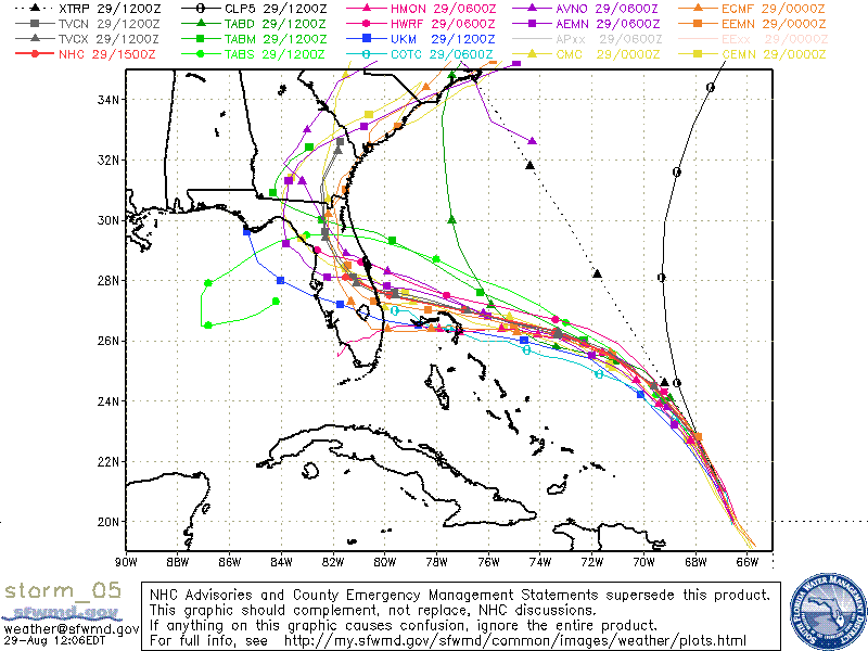
------------------------- Dora Hates You Edited: 08/29/2019 at 11:20 AM by dingpatch |
|
|
|
|
|
08/29/2019 11:50 AM
|
|
|
What the heck is that one model that has it going to bermuda? I'll have what that model is drinking...
|
|
|
|
|
|
08/29/2019 11:55 AM
|
|
|
FYI- In my experience over the years with all these hurricanes- the best place to go, besides frikkin Georgia, is Orlando. Just get in the middle of the state and stay away from any coasts. You really never know what these things are going to decide to do at the last minute. |
|
|
|
|
|
08/29/2019 12:01 PM
|
|
|
|
|
|
|
|
|
08/29/2019 12:04 PM
|
|
|
Rosen hotels have discounted rates (and are waiving pet fees) for Floridians fleeing the storm.
------------------------- Specializing in sarcasm and condescending rhetoric since 1971. Edited: 08/29/2019 at 12:21 PM by worksuxgetsponsered |
|
|
|
|
|
08/29/2019 12:31 PM
|
|
|
Does anyone know what the sustained windspeeds or gusts will be before MCO will suspend commercial flight ops?
|
|
|
|
|
|
08/29/2019 12:41 PM
|
|
|
|
|
|
|
|
|
08/29/2019 12:42 PM
|
|
|
usually tropical storm force... anyway, if you live in a low area (like myself) this is a concern:
Edited: 08/29/2019 at 08:32 PM by 2nd Light Forums Moderator |
|
|
|
|
|
08/29/2019 02:32 PM
|
|

------------------------- Dora Hates You |
|
|
|
|
|
08/29/2019 07:16 PM
|
|
|
Would someone get some before and after photos of the dunes along the 'mid reach' - Satellite, IHB, and Indialantic? It will be interesting to see how the storm affects the dunes, especially where there are seawalls vs. a natural dune line.
------------------------- http://www.crsurf.com ~ CR Surf Travel Company http://www.vacationsbygreg.com Instagram - @crsurf |
|
|
|
|
|
08/29/2019 08:31 PM
|
|
|
11 PM NHC update... UGH
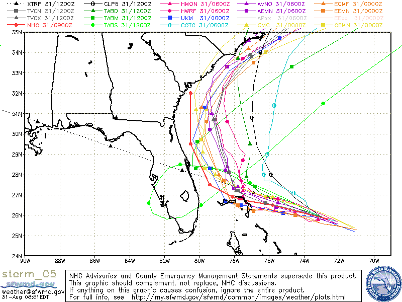
Hurricane Dorian Discussion Number 23 NWS National Hurricane Center Miami FL AL052019 1100 PM AST Thu Aug 29 2019 The NOAA and Air Force Reserve Hurricane Hunter aircraft have been tag-teaming the reconaissance of Dorian tonight, providing useful information about what has changed during the past several hours. They found the pressure has dropped to about 977 mb, with recent SFMR data of about 90 kt (also supported by flight-level winds). These data are also consistent with satellite imagery that show Dorian with a larger, deeper central dense overcast than this afternoon. Thus the wind speed is raised to 90 kt on this advisory. The initial motion is about the same as before, 325/10 kt. Dorian is expected to gradually turn to the west-northwest on Saturday, and westward on Sunday due to a building ridge over the southwestern Atlantic. While the model guidance generally shows this scenario in a broad sense, there are substantial timing differences among the guidance. The source of the uncertainty can be attributed to challenges in forecasting the strength and orientation of the mid-level ridge over the southeastern United States in a few days, along with exactly where and how large Dorian is by then. As you can imagine, with so many complex variables in play, it is no wonder the models have been having a difficult time nailing down the path of the hurricane. There's been a notable trend on this model cycle toward a slower, more westward track beyond 36 hours, which can be seen most strongly in the GFS-based guidance. The track forecast is shifted southward beyond 36 hours, and is about 30 n mi south of the previous one at 96 h. We will see if this southward trend in the models continues after the dropsonde data collected by the G-IV gets incorporated into the 00Z models. Users are reminded to not focus on the exact forecast track, as typical forecast errors at days 4 and 5 are around 155 and 205 miles, respectively. There is still substantial middle- and upper-level dry air on the south side of the hurricane, as shown by tonight's G-IV mission, which has been allowing only slow strengthening during the day. As Dorian turns west-northwestward, however, shear should drop somewhat due to it moving on the northeast side of an upper-level low near the Florida Straits, and the winds aloft will no longer be pointed toward the core, which will help decrease dry air entrainment. All these changes should promote intensification while Dorian moves over the 29C waters east of Florida, so the intensity forecast is raised from the previous one, consistent with the corrected-consensus guidance. Unfortunately, I don't see any large-scale factors that would prevent Dorian from becoming an extremely dangerous category 4 hurricane during the next few days. Edited: 08/29/2019 at 08:32 PM by paddleout |
|
|
|
|
|
08/30/2019 05:24 AM
|
|
|
^^ no problem Greg, always take before and after pics....I have some go pro footage of the actual reef(s) from a few weeks ago as well...maybe a while until it gets clear/clam enough to free dive again and see the "blocks"...The reefs actually looked real good, lots of growth...I "think" we will only see sustained winds around 90 mph ...hope so ...
|
|
|
|
|
|
08/30/2019 06:16 AM
|
|
|
So, , , , it can be said that "it is what it is", , , , but there is still too much uncertainty in its track. Most of the models are in pretty close agreement into Freeport but, from there it gets sketchy. The UKMet takes it acroos and into the gulf. BUT, BUT, BUT, , , , most of all the rest still takes it up the middle of the state as a CAT 1 or 2. That part might not seem that bad but, this thing is expected to be just crawling. How good is your property prepared for 24 hours of Cat 1 or 2? 24 hours for it to get from Palm Beack to Orlando????!!!!
And still, just as the models have brought it more southerly, there is a very good possibility that they could soon also take it more easterly! This is no joke. We could have a CAT 4 or 5 hit the sand at Miami and then turn north straight up the coast!!! EVERYBODY from Miami to Jacksonville might get a taste of a CAT 4 or 5!!!! IF it does come up the coastline the beachside areas, and most others out past 95 around here will never be the same. Tommorow is shutter day. My Ready Bag is almost complete. Most "current" scenarios tell me that I will probably head towards Ft. Myers or Tallahassee. No ideal solution yet. I'm guessing that even by Saturday afternoon they still won't have a good grip on the track. ------------------------- Dora Hates You |
|
|
|
|
|
08/30/2019 07:11 AM
|
|
|
Dude
A ready bag is supposed to be ready in a moments notice. It's been 4 days and yours still isn't ready? Just call it a suitcase and be honest. ------------------------- Replace turf grass with native plants that don't need irrigation and synthetic fertilizers or chemicals that can go into our waterways and ocean |
|
|
|
|
|
08/30/2019 07:19 AM
|
|
|
The absolutely best case right now for South Brevard beachside is for a TON of rain over an extended period of time with Cat 1 or 2 winds. Think Faye flooding and then some plus pretty high winds. That is the best case. The worst case is unimaginable. Prep for the worst, pray for the best.
|
|
|
|
|
|
08/30/2019 07:20 AM
|
|
|
Well, no. It will be prepared to be "ready" when needed. It is prepared for the expected specific mission.
Still deciding if I want to put a tent in the car, , , ,. May need to get a trenching tool! Everything will be in place tomorrow at noon. My first "raedy bag" was an Airmobile ruck and a duffle. My Cavalry Brigade was Nixon's "Ready Reaction Force". ------------------------- Dora Hates You Edited: 08/30/2019 at 07:21 AM by dingpatch |
|
|
|
|
|
08/30/2019 08:52 AM
|
|
|
Yep, F us!!!!! It really does look more-and-more that it is going to come up the cost. The current NHC track has it more easterly in the state but, there is a very good likelihood that it will soon be even more "east".
If it does come up the coast as a Cat 3 - 4 as slow as projected yes, it will be unimaginably devastating!!! ------------------------- Dora Hates You |
|
|
|
|
|
08/30/2019 09:22 AM
|
|
|
11 am updates look better. now a cat 3 at landfall thank god. landfall further south around PBCand then doing a sharp north hook.. but it will be weakening over land. if this thing can continue to trend even more south (more bahamas before FL) it could weaken morw. and if it can continue to trend east, that sharp north hook may happen before the coast, keeping it a little offshore like Matthew was (which wasn't TOO bad windwise, and Im beachside) for now Ill take this 11am update! |
|
|
|
|
|
08/30/2019 09:42 AM
|
|
|
bless u paddleout!
|
|
|
|
|
|
08/30/2019 10:28 AM
|
|
|
A 100 mile swing to the East and it's all for nothing. Come on Mother Nature, toss that curve ball.
------------------------- I was right. |
|
|
|
|
|
08/30/2019 10:44 AM
|
|
|
That little "jog" to the east that Mathew did at the last minute is what saved our asses here in Brevard.
There is a growing chance that we Will Not be so lucky this time. The latest model runs are a hair or two north of previous, and they are picking up on the slow down. This SOB really could hit the coast as a 3 or 4 and then just CREEP right up the coast as a 2 or 3!!!!!! How can your house stand CAT 2 or 3 winds? My neighbor is, I guess, in denial. He's lived in Brevard for about 35 years and he "thinks" he has been through a hurricane before. He has no plans to evacuate (he is not going to leave his "home" to the storm). The last hurricane that actually had an "eye" over Brevard was David 1979. Mathew was pretty bad but, I'm not sure if what we got was considered to be "sustained" hurricane force wind. Frances in 2004 gave Brevard winds in the 60s and a gust of 78 at MI Airport. Jeanne in 2004 had gusts in Melbourne up to 79. ------------------------- Dora Hates You |
|
|
|
|
|
08/30/2019 10:36 AM
|
|
|
Dude, this has become an all too common fire drill in the past 5 years. Someone needs to tell Mother Nature it's the Carolinas' turn...jk. Hunker down boys.
------------------------- If you're not part of the solution, you're part of the precipitate. |
|
|
|
|
|
08/30/2019 10:45 AM
|
|
|
------------------------- sneedeker |
|
|
|
|
|
08/30/2019 10:51 AM
|
|
|
Bahamas gonna get nailed. Das fo sho.
|
|
|
|
|
|
08/30/2019 11:07 AM
|
|
|
welp. cat 3 now
|
|
|
|
|
|
08/30/2019 11:08 AM
|
|
|
harrietscrubman, note the "jk" ...I'm originally from the Carolinas and have many friends and family still there. MAtthew indeed put a hurting on SC. I had a friend (old highschool chemistry teacher) lose hundreds of trees on his pine tree farm. He put in a lot of work to harvest what he could, clean up, and replant. I don't wish that kind of work and stress on anyone.
------------------------- If you're not part of the solution, you're part of the precipitate. |
|
|
|
|
|
08/30/2019 11:21 AM
|
|
|
ah yes, name calling, lets keep it up... ^ as long as you say JK after something not cool it makes it ok, especially if you have a connection to what you reference. sorry i forgot.
------------------------- sneedeker Edited: 08/30/2019 at 11:24 AM by harrietdubman |
|
|
|
|
|
08/30/2019 12:27 PM
|
|
|
|
|
|
08/30/2019 02:00 PM
|
|
|
Hmmmmm, , , , Wilma crossed the state from Cape Romano and exited in Jupiter and, as such, never got that close to Brevard.
Well, yep, , , , the models are pulling it back to the East. The 1 PM "Intermediate Advisory". Has it as a CAT 3 and pretty much brings it straight up I95 after landfall!!!! BUT, the NHC is still pretty much "in the dark" as to what this will really do. I guess that most of the models are still in very close agreement up to the point of Dorian getting to Freeport. After Freeport, there's a lot of "spaghetti". BUT, , , , the tropical blogs are all pretty much talking about it going more east and otherwise may not make landfall in Florida!!?? If it is going to be "out at sea" we better hope that it is 100 miles offshore and otherwise takes its right turn at Freeport. WE SHALL SEE. ------------------------- Dora Hates You |
|
|
|
|
|
08/30/2019 02:06 PM
|
|
|
AND, , , , , by fooking golly, the 5 o'clock just came out with a track right up the beach from Fort Pierce to Jacksonville!!!!
Interactive Map ------------------------- Dora Hates You Edited: 08/30/2019 at 02:43 PM by dingpatch |
|
|
|
|
|
08/30/2019 02:07 PM
|
|
|
I wood take a right turn @ Freeport. I mean, duh. Thats a no brainer.
|
|
|
|
|
|
08/30/2019 02:09 PM
|
|
|
ding - David was a small Cat 1 and, while the eye passed right over my evac point (in a small duplex behind the old Eau Gallie A&P), it really didn't do much to my hidey-hole or my beachside neighborhood. I'm sure you remember Cleo in '64, though. (We both lived in the same neighborhood; I was a sort-of friend of Keith's). Still not a bad one, but, bad enough to take out Patrick Pier. We should show some appreciation for people who decide to stay beachside for a Cat 4, though. It will help to cull the herd. It can only help to take out the stupid.
|
|
|
|
|
|
08/30/2019 02:18 PM
|
|
|
Yep, I guess it had to be Cleo. We had river fish swimming on NE 1st Street
------------------------- Dora Hates You |
|
|
|
|
|
08/30/2019 02:24 PM
|
|
|
And, one of the "weather gurus" typed this: "I think the NHC is feeling a little more confidence in the Euro model shift. The 11pm and tomorrow mornings 5am advisories will tell a tale for certain."
------------------------- Dora Hates You |
|
|
|
|
|
08/30/2019 02:37 PM
|
|
|
Much harder north in the last two forecasts. Keep swingin babay!
------------------------- I was right. |
|
|
|
|
|
08/30/2019 02:07 PM
|
|
|
5PM NHC update- some good, some bad. Bad is its back to a CAT 4 at landfall. the good/maybe not so good is that the track has shifted more east and northeast. The east shift is good, because its continuing to trend toward that curve that may end up keeping Dorian off the coast if the trend keeps up. The north shift is bad becuase that puts Florida landfall further north- the midline of the cone is now over Fort Pierce / Port St. Lucie area.. Let keep hoping for more eastward shifting and some downgrading in intensity. |
|
|
|
|
|
08/30/2019 04:43 PM
|
|
|
What exactly is the "euro model shift"? |
|
|
|
|
|
08/30/2019 04:47 PM
|
|
|
Well I assumed that the "euro model shift" was the ECMWF model- so I just took a look at the latest (12z run at this time) and it has the storm OFF THE COAST, hanging that right before it hits land (right at about Palm Beach) ..now thats a good trend, but that model still shows the west side of Dorian's winds over the barrier islands in brevard. Pretty strong winds too.. so lets hope it keeps moving east with each run. a couple more Eastward shifts and SAYONARA stupid storm.. |
|
|
|
|
|
08/30/2019 08:26 PM
|
|
|
11PM NHC update, has a little bit more NE shift. The centerline has it aimed right at Brevard, but a bit more of this NE in each update and we might have a decent chance at an offshore storm.
Weather Underground currently has it back down to a CAT 3 at landfall, http://www.wunderground.com/hu...m-dorian?map=forecast but the storm is really strong out there right now (read NHC discussion #25).. 140 mph sustained winds. It seems the tracking is still being held to the west by the GFS, with any luck that one will get on board with the NE shift in future runs. Probably the most detailed update that tells it like it is comes from Levi at Tropical Tidbits in his latest video: Edited: 08/30/2019 at 08:33 PM by paddleout |
|
|
|
|
|
08/30/2019 09:24 PM
|
|
|
Www.windy.com shows the eye Under 20 miles wide currently and winds much slower than weather.com.
Windy had indian harbor beach winds not breaking tropical depression / tropical storm on gust levels with or without landfalls. Anyone else trusting windy.com.
------------------------- it's never too late to have a happy childhood... |
|
|
|
|
|
08/31/2019 05:27 AM
|
|
|
I would trust NHC and maybe Levi at Tropical Tidbits.
Looking better this morning, but remember that NHC cone is huge. Hurricane steering is extremely complex and this storm is super powerful and still going to be very close even if it is offshore. somebody sneezes and you are in the eyewall.. This is probably why windy is showing that- the latest GFS run (06z) is shown below. Last night that same model had it crashing through Brevard with winds sustained at 140... so it's a good morning for Florida, but it would take just the slightest change to have that thing back on our doorstep.. look at those winds! http://ibb.co/LNSR6vk Edited: 08/31/2019 at 05:38 AM by paddleout |
|
|
|
|
|
08/31/2019 05:36 AM
|
|
|
The Weather Tiger guy says that it is not good when the best case is a Matthew-like brush to the coast (and he only gives that a 10-15% chance). Best case (right now) is still a lot of wind for many hours (it is moving very slowly), a lot of water and a LOT of flooding. Keep filling sandbags.
|
|
|
|
|
|
08/31/2019 05:34 AM
|
|
|
Keep at it...RECURVE RECURVE RECURVE...
Seems like it may be working. |
|
|
|
|
|
08/31/2019 06:31 AM
|
|
|
When Floyd passed by in 1999 I surfed Cherie Down with my friend Dallas after it passed and the wind slacked for at least two hours solid double overhead and offshore. So peaky and sweet. I should have evacuated but didn't. Nobody else out for a while because anyone smart evacuated and no one can come over as they close bridges.
Floyd was a Cat 4 storm with this from wikipedia: Floyd was once forecast to strike Florida, but turned away. Instead, Floyd struck The Bahamas at peak strength, causing heavy damage. It then moved parallel to the East Coast of the United States, Edited: 08/31/2019 at 06:32 AM by Greensleeves |
|
|
|
|
|
08/31/2019 06:45 AM
|
|
|
For those of you like me, who wait for levi cowens tropical update video each evening [tropical tidbits]. Follow him on twitter, good stuff all day. He just mentioned something about dorian slowing enough that the cold water wake could catch up to it, weakening it but expanding the wind field. The Gulf stream plays a factor also.
|
|
|
|
|
|
08/31/2019 07:08 AM
|
|
|
Thanks RC that link was pretty cool- looks like good conditions from Wed on.. |
|
|
|
|
|
08/31/2019 07:38 AM
|
|
|
What is not to like about this spaghetti run?????!!!!!
------------------------- Dora Hates You |
|
|
|
|
|
08/31/2019 08:01 AM
|
|
|
What am I going to do with all of this beer now?
|
|
|
|
|
|
08/31/2019 08:08 AM
|
|
|
WOOT 11 am update even more offshore |
|
|
|
|
|
08/31/2019 09:15 AM
|
|
|
Yes!!! Like Hurricane Floyd 20 years ago, that monster threatened to eliminate our peninsula, then saved by the High pressure
------------------------- Brevard Surf Report |
|
|
|
|
|
08/31/2019 09:23 AM
|
|
|
The 12:06 spaghetti run is even better BUT, the UKMet is not changed and is now to the left of the NHC track!

------------------------- Dora Hates You |
|
|
|
|
|
08/31/2019 11:06 AM
|
|
|
epic north backlash swell late next week into the weekend.
|
|
|
|
|
|
08/31/2019 11:15 AM
|
|
|
Seeing that too.. 9/7, 9/8, and 9/9 COULD be all time! If you can time it right and forecast holds here's the scenario:
Epic SoBe on 9/2 and 9/3 (maybe getting started late 9/1)
Pumping on the Space Coast for 9/4 with leftovers 9/5 morning
Rest day on 9/6
All time for most of the state 9/7-9/9
There's your week long+ FL "surf trip".
Gonna have to want it tho
|
|
|
|
|
|
08/31/2019 11:47 AM
|
|
|
Dorian...Cat 5, recurve...uh, yeah, gonna be epic swell coming... (knock on wood)
|
|
|
|
|
|
08/31/2019 01:06 PM
|
|

------------------------- sneedeker |
|
|
|
|
|
08/31/2019 01:46 PM
|
|
|
There's some energy out there right now. Maybe some small traces of the forerunners mixed with the E wind swell
|
|
|
|
|
|
08/31/2019 05:07 PM
|
|
|
Still plenty of time, and ways, for Dorian to stay on its current heading and make land fall on top of us. Many models ran at 18z push it back towards us!! Waiting for the NHC 11 o'clock will have a very tight sphincter factor!!!!!
------------------------- Dora Hates You |
|
|
|
|
|
08/31/2019 06:25 PM
|
|
|
Yes, Levi's Saturday night video was uncomfortable to watch... its back to being scary... |
|
|
|
|
|
08/31/2019 06:30 PM
|
|
|
Lots of people letting guard down here in So Fla. Levi report is very spot on, and we need to watch this still.
------------------------- "The power of accurate observation is commonly called cynicism by those who do not have it." - George Bernard Shaw |
|
|
|
|
|
08/31/2019 07:58 PM
|
|
|
Well, 11PM NHC update just came out and they didn't really shift it more towards Florida- more or less the same, despite all the scarey shifts back towards the coast on the 18z model runs.. Guess this is a good thing |
|
|
|
|
|
08/31/2019 09:08 PM
|
|
|
|
|
|
|
|
|
08/31/2019 09:23 PM
|
|
|
yep read that..
its sketchy still. but they didnt move the cones or the midline Still I am assuming my place will be seeing Cat 3 conditions and Im prepping for that.. Edited: 08/31/2019 at 09:25 PM by paddleout |
|
|
|
|
|
08/31/2019 09:36 PM
|
|
|
"The eastward trend became a bit more tentative with the 18Z model runs, several of which (including the GFS) nudged their forecast tracks back toward the west. The 18Z run of the HWRF model brought Dorian inland near Kennedy Space Center on Tuesday night and on into southeast Georgia by Thursday. It's just one of many possibilities, but a sign that we cannot yet dismiss a destructive landfall on the Southeast U.S. coast. Remember: If you are in the cone of uncertainty, you are at risk of a direct strike!"
Not in the clear yet, folks. Damn |
|
|
|
|
|
09/01/2019 03:37 AM
|
|
|
5am shifted a bit more west. geesh
|
|
|
|
|
|
09/01/2019 04:30 AM
|
|
|
Who is "Levi" and please post a link.
------------------------- Dora Hates You |
|
|
|
|
|
09/01/2019 04:36 AM
|
|
|
|
|
|
09/01/2019 04:48 AM
|
|
|
a def shift west at the 5am
------------------------- "The power of accurate observation is commonly called cynicism by those who do not have it." - George Bernard Shaw |
|
|
|
|
|
09/01/2019 04:59 AM
|
|
|
Happy Labor Day? 1935
------------------------- add a signature since I'm here in profile anyway Edited: 09/01/2019 at 05:04 AM by tom |
|
|
|
|
|
09/01/2019 05:02 AM
|
|
|
aaand we have a cat5
|
|
|
|
|
|
09/01/2019 05:07 AM
|
|
|
Ugh, Poor Abaco Islands.
|
|
|
|
|
|
09/01/2019 06:45 AM
|
|
|
9:30 update from latest hurricane hunter data. 175mph winds and 922mb pressure
|
|
|
|
|
|
09/01/2019 07:10 AM
|
|
|
Yes, 5am shifted the NHC official track a bit more west.
Of the 3 current main model runs: GFS has it grazing Brevard, but with the eye offshore ECMWF has the same with it a little more offshore and the always annoying HWRF has the west side of the eyewall over Cape Canaveral- with winds there about 110 Knots. Way too close for comfort.. we need that RECURVE chant again.. Hoping for some better shifting in the 11am update Edited: 09/01/2019 at 07:10 AM by paddleout |
|
|
|
|
|
09/01/2019 07:55 AM
|
|
|
913MB!!!
Hopefully this saw blade hits a few nails in the bahamian hills Edited: 09/01/2019 at 09:03 AM by 2nd Light Forums Moderator |
|
|
|
|
|
09/01/2019 07:59 AM
|
|
|
11am Sunday NHC:
Maximum sustained winds have increased to near 180 mph (285 km/h) with higher gusts. Dorian is a extremely dangerous category 5 hurricane on the Saffir-Simpson Hurricane Wind Scale. Some fluctuations in intensity are likely, but Dorian is expected to remain a powerful hurricane during the next few days. |
|
|
|
|
|
09/01/2019 08:00 AM
|
|
|
Hope Town Abaco...probably will not be there by tomorrow. I hope everyone evacuated.
|
|
|
|
|
|
09/01/2019 08:01 AM
|
|

Edited: 09/01/2019 at 08:01 AM by Plan B |
|
|
|
|
|
09/01/2019 08:09 AM
|
|
|
Well... this is the Big One folks. |
|
|
|
|
|
09/01/2019 08:22 AM
|
|
|
Levi cowen twitter feed giving real time updates. What a great resource. https://twitter.com/tropicaltidbits
|
|
|
|
|
|
09/01/2019 08:37 AM
|
|
|
DORIAN BECOMES THE STRONGEST HURRICANE IN MODERN RECORDS FOR THE NORTHWESTERN BAHAMAS. ...CATASTROPHIC CONDITIONS OCCURING IN THE ABACOS ISLANDS...
And, , , , Levi's latest Tweet: Pinned Tweet Levi Cowan ? @TropicalTidbits 10m10 minutes ago More Hurricane Watches have been issued for the eastern coast of Florida. This track is *very close* to the coast. Any wiggle to the left at all could have devastating consequences, and we can't predict the storm with that level of precision. Be prepared. Better safe than sorry. ------------------------- Dora Hates You Edited: 09/01/2019 at 08:42 AM by dingpatch |
|
|
|
|
|
09/01/2019 09:05 AM
|
|
|
Levi really is awesome. I will be donating to his site when this is all over. He should be on TV |
|
|
|
|
|
09/01/2019 09:09 AM
|
|
|
I'm hearing that a couple network news crews are taking over some beach front hotels in Indiatlantic.
------------------------- Dora Hates You |
|
|
|
|
|
09/01/2019 09:20 AM
|
|
|
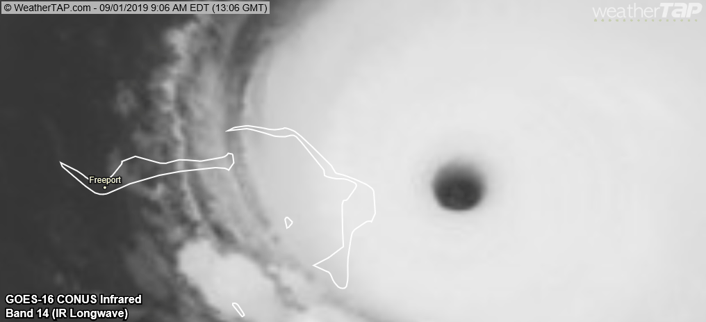
Hope Town just went thru the Western Wall. Checking twitter, network outage reports 6 percent connectivity. Hope Town lost power 6 hours ago. Currently in the eye. Sunday Noon.
|
|
|
|
|
|
09/01/2019 09:36 AM
|
|
|
Jim Edds
? Verified account @ExtremeStorms Follow Follow @ExtremeStorms More The dock is now underwater, I could barely stand up getting out there 990mb OK that's gonna wrap up the social media if you want to see the footage tune in to the weather channel. |
|
|
|
|
|
09/01/2019 09:39 AM
|
|
|
1086 mb (32.08 inches of mercury): Highest Ever Recorded
1030 mb (30.42 inches of mercury): Strong High Pressure System 1013 mb (29.92 inches of mercury): Average Sea Level Pressure 1000 mb (29.54 inches of mercury): Typical Low Pressure System 980 mb (28.95 inches of mercury): CAT 1 Hurricane or a very intense mid-latitude cyclone 950 mb (28.06 inches of mercury): CAT 3 Hurricane 870 mb (25.70 inches of mercury): Lowest Ever Recorded (not including tornadoes) |
|
|
|
|
|
09/01/2019 09:56 AM
|
|
|
What, no surf report? Bout head hi, onshore and drift. Nobody out melbeach.
------------------------- add a signature since I'm here in profile anyway |
|
|
|
|
|
09/01/2019 09:59 AM
|
|
|
911mb how low will it go. 1pm 185mph. saw a few people at perk. dead high tide earlier, biggest wave surfed was 3-4ft overhead on rider. couldn't tell who. 7@13 on 20
Edited: 09/01/2019 at 10:02 AM by RiddleMe |
|
|
|
|
|
09/01/2019 11:43 AM
|
|
|
Gulfster....

Wavecaster.... 

-------------------------  Puerto Rico 11 - 24 - 2013 Puerto Rico 11 - 24 - 2013
|
|
|
|
|
|
09/01/2019 12:12 PM
|
|
|
WTNT45 KNHC 011457
TCDAT5 Hurricane Dorian Discussion Number 33 NWS National Hurricane Center Miami FL AL052019 1100 AM EDT Sun Sep 01 2019 Air Force and NOAA reconnaissance planes penetrated the distinct eye of Dorian, and found that the hurricane has become extremely intense with a stadium effect in the eye. The NOAA plane reported a peak flight-level wind of 159 kt, while the SFMR from both planes have measured winds between 155 and 170 kt. A dropsonde from the NOAA plane measured a wind gust of 176 kt at the surface. A blend of these measurements yield to an initial intensity of 155 kt, making Dorian the strongest hurricane on record in the northwestern Bahamas. For the next few days, Dorian should experience some fluctuations in intensity, and in addition to eyewall replacement cyclone, the interaction with the northwestern Bahamas should weaken the hurricane slightly. After 3 days, as Dorian moves northward along or offshore of southeast United States coast, the shear is forecast to increase, resulting in a more distinct gradual weakening. Reconnaissance plane and satellite fixes indicate that Dorian, as anticipated, has slowed down and is moving toward the west or 270 degrees at 6 kt. The steering currents are collapsing and Dorian is expected to slow down even more, prolonging its catastrophic effects in the northwestern Bahamas. The NHC forecast calls for a slow west to west-northwest motion during the next 48 hours, with a turn to the north and an increase in forward speed as the mid-level trough along the eastern United States deepens and becomes the dominant steering feature. The current forecast is only a few miles west of the previous one and is basically on top of the multi-model consensus. Both the deterministic and consensus tracks have shown the usual variability to the right or to the left from run to run, but the overall trend is for the hurricane to turn northward offshore but very close to the Florida peninsula. Given the uncertainty in the track forecast and the anticipated increase in size of the hurricane, a Hurricane Watch and Storm Surge Watch have been issued for a portion of the east Florida coast. It is emphasized that although the official track forecast does not show landfall, users should not focus on the exact track. A small deviation to the left of the track could bring the intense core of the hurricane its dangerous winds closer to or onto the coast. |
|
|
|
|
|
09/01/2019 12:12 PM
|
|
|
That's 202mph
|
|
|
|
|
|
09/01/2019 12:29 PM
|
|
|
Video from eye. i think hope town. total destruction. now going thru East side of wall.
http://twitter.com/i/status/1168228670554746881 |
|
|
|
|
|
09/01/2019 12:44 PM
|
|
|
From Jamie Cash, Hope Town: Consolidating news- this is what I've heard so far- Abaco Inn has lost several villas, Sea Spray is leveled, HT Lodge has collapsed. Many houses have been destroyed/roofs lost, including Linda and Craig Knowles house, JoAnn Feinstein's and Billy Gates as well. I heard the Knowles family is safe, hoping the same for the Gates. Skyview in Ann Pats bay lost their doors and furniture sucked outside. Marnies Creek subdivision is badly hit as well. No real update from town or North End. If you have any other info, please share!
|
|
|
|
|
|
09/01/2019 02:51 PM
|
|
|
Even if it does not trend any more to the West, it will be TOO CLOSE FOR COMFORT!!!

From a Moderator on flhurricane.com: The image above is about the last fully full daylight visible image to catch all three of these features in the W Atlantic From left to right: Gulf Low, Cat 5 Dorian, Low SSE of Bermuda All three appear to be stronger and/or more organized than previously forecast. Given their relatively close proximity and better-than-forecast states, there may be some unexpected influence to come. It will be interesting to see if the next run of 0z and 12Z models pick up on anything. ------------------------- Dora Hates You Edited: 09/01/2019 at 02:59 PM by dingpatch |
|
|
|
|
|
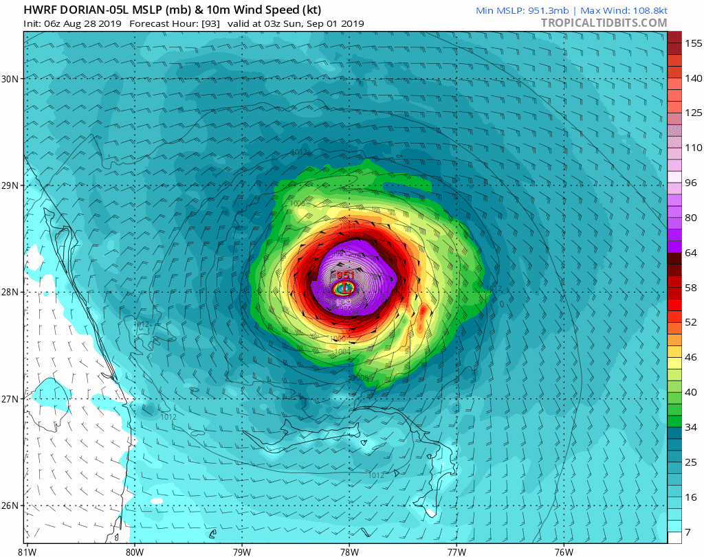
09/01/2019 06:52 PM
|
|
|
https://www.tropicaltidbits.com/
Guys what the Sunday night video on Levis page. the HWRF has this coming in around the Cape. Please take a look at video. Good explanation. Just one model but makes a lot of sense. ------------------------- "The power of accurate observation is commonly called cynicism by those who do not have it." - George Bernard Shaw |
|
|
|
|
|
09/01/2019 08:20 PM
|
|
|
|
|
|
|
|
09/01/2019 09:25 PM
|
|
|
Just for reference it's looking like this thing will come about twice as close as Floyd did which means it's about twice as dangerous. The track has trended back and forth a couple times so hopefully there's still time for another eastward trend Monday. This thing is so right on the line between being about surfing vs being about something completely else. That said SoBe is about to puuump for probably 2 and a half days! Just a 20 mile eastward nudge from current forecast would make all the different for Space Coast surf Wednesday, otherwise fetch will be cut off and whatever's in the water gets blown flat quick by the offshores.
|
|
|
|
|
|
09/02/2019 03:51 AM
|
|
|
Relating a message from @ExtremeStorms from a trusted 3rd party - everyone staying at the HopeTown Inn in Hope Town #Bahamas is safe. They got the eye and Jim measured 911.2hPa minimum pressure during #hurricane #Dorian
|
|
|
|
|
|
09/02/2019 05:28 AM
|
|
|
Well, so far, the track looks livable for us.
Please remember, you can hide from the wind but, you must run from the water. ------------------------- Dora Hates You |
|
|
|
|
|
09/02/2019 07:10 AM
|
|
|
>>. "Even more crazy... the weather in Freeport - winds are blowing at 60 from the NW pressure 29.19 and still dropping. While center of Cat 5 Dorian is just 30 miles away! 30 miles down the road yet the wind is 100 MPH less. This is more tornado then hurricane. Its so compact. The feeder bands aren't even expanding, this storm is all core." <<
------------------------- Dora Hates You |
|
|
|
|
|
09/02/2019 12:59 PM
|
|
|
>>. "Even more crazy... the weather in Freeport - winds are blowing at 60 from the NW pressure 29.19 and still dropping. While center of Cat 5 Dorian is just 30 miles away! 30 miles down the road yet the wind is 100 MPH less. This is more tornado then hurricane. Its so compact. The feeder bands aren't even expanding, this storm is all core." << All hurricane force winds only extend 45 miles out from the center, so this makes since. Let's hope it shifts 100 or more miles to the East. ------------------------- I was right. Edited: 09/02/2019 at 01:01 PM by Cole |
|
|
|
|
|
09/02/2019 02:06 PM
|
|
|
I've always thought this guy is top notch, Jeff Masters. He writes well calls it heavy when it is. This one is interesting as there is extended writing at end on our President and his repeated Cat 5 senility.
Jeff Master Category 6 Blog, wunderground. Edited: 09/02/2019 at 02:06 PM by Greensleeves |
|
|
|
|
|
09/02/2019 02:29 PM
|
|
|
Currently watching someone try to get out on the pier cam, gotta applaud the effort he's been at it about 20 min and hasn't moved much. Anyone check jetty park? Considered hitting south beach today, glad I didn't it sub waist high with easily 100+ people on it
|
|
|
|
|
|
09/02/2019 02:36 PM
|
|
|
Bahamas weather station.
Settlement Point, Grand Bahama Island http://www.ndbc.noaa.gov/station_page.php?station=spgf1 ------------------------- I was right. |
|
|
|
|
|
09/02/2019 08:11 AM
|
|
|
Very glad to finally see this today:
Levi Cowan ? @TropicalTidbits 4h Another potentially piece of good news for #Florida: The one major model that had a direct landfall of #Dorian (HWRF) has trended offshore overnight. Other models like ECMWF & GFS trended a little closer to the coast (~50 miles offshore), a track that would still be dangerous. Edited: 09/02/2019 at 08:29 AM by paddleout |
|
|
|
|
|
09/02/2019 12:18 PM
|
|
|
thank you HWRF!!!
Boca Raton Surf Cam looking good right now ------------------------- "The power of accurate observation is commonly called cynicism by those who do not have it." - George Bernard Shaw |
|
|
|
|
|
09/02/2019 03:30 PM
|
|
|
Hurricane Dorian Discussion Number 38
NWS National Hurricane Center Miami FL AL052019 500 PM EDT Mon Sep 02 2019 Dorian remains an impressive hurricane in satellite imagery. Recent radar and aircraft observations are again showing signs of a concentric eyewall structure which might be one of the factors that has led to a decrease in the peak winds and a small expansion of the wind field. An Air Force Reserve Hurricane Hunter aircraft reported peak flight-level winds of 129 kt, SFMR winds of 121 kt, and a central pressure that has risen to 940 mb. Based on these observations, the initial wind speed has been set at 125 kt. Some additional decrease in wind speed is likely in the short term due due to a possible eyewall replacement and upwelling of cooler waters caused by the very slow motion of the hurricane. Although some additional slow weakening is forecast while the hurricane moves northward along the southeastern United States coastline due to increasing southwesterly shear, Dorian is forecast to remain a powerful hurricane during that time. The NHC intensity forecast forecast is a blend of the latest statistical and and consensus model guidance. Dorian has become nearly stationary this afternoon with the two most recent aircraft fixes showing essentially no motion. A slow westward to west-northwestward motion should resume overnight and continue into early Tuesday, with the eye and devastating winds only slowly pulling away from Grand Bahama Island. By Tuesday afternoon, Dorian should begin its much anticipated northwestward turn as a weakness becomes more pronounced in the subtropical ridge. Although the center of Dorian is forecast to move near, but parallel to, the Florida east coast, only a small deviation of the track toward the west would bring the core of the hurricane onshore. A broad mid- latitude trough should help turn Dorian northeastward by Wednesday night, and the track models show the center coming precariously close to the southeastern United States coast. The tracks from the 1200 UTC runs of the global models have remained fairly stable, which has resulted in little overall change to the latest NHC track forecast. Users are reminded that the hurricane is not a point, and that life-threatening storm surge and hurricane-force winds extend far from the center. Regardless of the exact forecast track, strong winds and a life-threatening storm surge are likely along a portion of the U.S east coast from Florida through the Carolinas. Key Messages: 1. Devastating winds and storm surge will continue to affect Grand Bahama Island through tonight. Everyone there should remain in shelter and not venture into the eye. 2. Life-threatening storm surge and dangerous hurricane-force winds are expected along portions of the Florida east coast and the coasts of Georgia and South Carolina, regardless of the exact track of Dorian's center. Water levels could begin to rise well in advance of the arrival of strong winds. Residents in these areas should follow advice given by local emergency officials. 3. The risk of life-threatening storm surge and hurricane-force winds continues to increase along the coast North Carolina. Residents in these areas should follow advice given by local emergency officials. 4. Heavy rains, capable of producing life-threatening flash floods, are expected over northern portions of the Bahamas and coastal sections of the southeast and lower mid-Atlantic regions of the United States through Friday. FORECAST POSITIONS AND MAX WINDS INIT 02/2100Z 26.8N 78.4W 125 KT 145 MPH 12H 03/0600Z 27.0N 78.7W 115 KT 130 MPH 24H 03/1800Z 27.6N 79.1W 110 KT 125 MPH 36H 04/0600Z 28.7N 79.7W 110 KT 125 MPH 48H 04/1800Z 30.0N 80.1W 105 KT 120 MPH 72H 05/1800Z 32.8N 78.6W 95 KT 110 MPH 96H 06/1800Z 36.6N 73.1W 80 KT 90 MPH 120H 07/1800Z 43.5N 64.0W 75 KT 85 MPH...POST-TROP/EXTRATROP |
|
|
|
|
|
09/02/2019 04:06 PM
|
|
|
Saw Cherie Down at 1300. Kite boarders were killing it. All the way outside. One dude getting 8-10 sec air time. Looked like serious fun. it gave some perspective to the wave size. 10-12', possible bigger sets. High tide to the vegetation. Foamy and a lot of conch shells.....
|
|
|
|
|
|
09/03/2019 06:01 AM
|
|
|
Saw Cherie Down at 1300. Kite boarders were killing it. All the way outside. One dude getting 8-10 sec air time. Looked like serious fun. it gave some perspective to the wave size. 10-12', possible bigger sets. High tide to the vegetation. Foamy and a lot of conch shells..... I wonder if treasures will be found afterwards. Maybe time to get a metal detector. |
|
|
|
|
|
09/03/2019 06:05 AM
|
|
|
Matthew (or was it Irma?) dug up and exposed an old wooden shipwreck here in St. A
|
|
|
|
|
|
09/03/2019 05:36 AM
|
|
|
Geez. Dorian, get a move on. Models show it moving north but still meandering around grand bahama island.
|
|
|
|
|
|
09/03/2019 12:21 PM
|
|
|
Looking at weather.com future radar looks like around 8pm Brevard may see the fringes of tropical storm winds.
from NHC - - - - WIND SPEED PROBABILITIES FOR SELECTED LOCATIONS - - - - FROM FROM FROM FROM FROM FROM FROM TIME 12Z TUE 00Z WED 12Z WED 00Z THU 12Z THU 12Z FRI 12Z SAT PERIODS TO TO TO TO TO TO TO 00Z WED 12Z WED 00Z THU 12Z THU 12Z FRI 12Z SAT 12Z SUN FORECAST HOUR (12) (24) (36) (48) (72) (96) (120) - - - - - - - - - - - - - - - - - - - - - - - - - - - - - - - - - - COCOA BEACH FL 34 83 8(91) X(91) 1(92) X(92) X(92) X(92) COCOA BEACH FL 50 6 10(16) 2(18) X(18) X(18) X(18) X(18) COCOA BEACH FL 64 1 2( 3) X( 3) X( 3) X( 3) X( 3) X( 3) PATRICK AFB 34 69 10(79) 1(80) 1(81) X(81) X(81) X(81) PATRICK AFB 50 2 5( 7) 1( 8) X( 8) X( 8) X( 8) X( 8) Edited: 09/03/2019 at 12:22 PM by Central Floridave |
|
|
|
|
|
09/03/2019 12:24 PM
|
|
|
So, if I read that right. 64knots (73 mph) can be expected for Cocoa beach.
|
|
|
|
|
|
09/03/2019 12:27 PM
|
|
|
Tonight...Dorian is presently forecast to be east of Brevard
county late tonight during its trek northward. Gusty winds and occasional rainband squalls will be of primary concern overnight. Hurricane force winds gusts in organized squalls will remain possible with gradient winds to tropical storm force especially in the coastal zones. |
|
|
|
|
|
09/03/2019 03:47 PM
|
|
|
Just heard on NOAA radio Dorian is even with Vero now about100 miles out. Moderate rain and gusty winds to maybe T.S. level in Vero now. Beachside. Very grateful.
------------------------- Replace turf grass with native plants that don't need irrigation and synthetic fertilizers or chemicals that can go into our waterways and ocean Edited: 09/03/2019 at 04:09 PM by daner |
|
|
|
|
|
09/03/2019 03:53 PM
|
|
|
I'm hearing that folks are losing power in Melbourne Beach, Floridana, etc.
But the Surf Guru Melbourne Beach cam is still running.. waves aren't near the dune- still showing sand, but it is low tide right now. We definitely lucked out on this one.. as Daner said, very grateful.. The trees here in Orlando are barely even rustling. Edited: 09/03/2019 at 03:55 PM by paddleout |
|
|
|
|
|
09/03/2019 04:12 PM
|
|
|
Power is still on down here off Atlantic, south of Mel Beach Publix. Had a tornado warning around 6pm.
------------------------- R I P Mama G. @Salt.And.Savagery.Fishing @Laserwolf.Laserwolf |
|
|
|
|
|
09/03/2019 04:39 PM
|
|
|
RECURVE RECURVE RECURVE
|
|
|
|
|
|
09/03/2019 04:49 PM
|
|
|
Going to be a long night but very grateful that it was not a full-on Cat 5 hitting us
If you are in Satellite please keep us updated. Edited: 09/03/2019 at 04:50 PM by seaspray |
|
|
|
|
|
09/03/2019 05:14 PM
|
|
|
Going to be a long night but very grateful that it was not a full-on Cat 5 hitting us If you are in Satellite please keep us updated. Sitting here next to Pineda Cswy, raining, windy as hell, PAFB reporting sustained North winds at 36, gusts to 48 as of 700pm PAFB Power still on. So sad for Abaco. Have a few connections there and it's devastating digesting what happened to them and realizing there were scenarios of how that could have been us. Brevard escaped another disaster. Edited: 09/03/2019 at 05:22 PM by rc |
|
|
|
|
|
09/03/2019 06:01 PM
|
|
|
New media are getting helicopter and radar coverage from the Bahamas. Washington Post and NY Times have good info, and I expect Miami and Orlando media to get involved with aid. People are already collecting generators.
|
|
|
|
|
|
09/03/2019 04:52 PM
|
|
|
North Palm Beach County I think I may have seen a gust to 40mph. Feeling very fortunate with this beast.
Looks like you guys are getting it pretty good right now up in Melbourne Cocoa Beach Area, stay safe! ------------------------- "The power of accurate observation is commonly called cynicism by those who do not have it." - George Bernard Shaw |
|
|
|
|
|
09/03/2019 06:03 PM
|
|
|
It's 9:01pm, near pelican. Gusty and very windy. We have power but lost internet connectivity. Praying for those in the Bahamas.
------------------------- 
|
|
|
|
|
|
09/03/2019 06:09 PM
|
|
|
heard one power line down near pineda. other than that, judging by my pool maybe 1 inch of rain. only one palm frond down in the yard. bullet dodged
|
|
|
|
|
|
09/05/2019 05:47 AM
|
|
|
Helicopter vid. Abaco Inn at 2:09
|
|
|
|
|
|
09/05/2019 06:38 AM
|
|
|
Perhaps not "flooded", just Gone!!!!
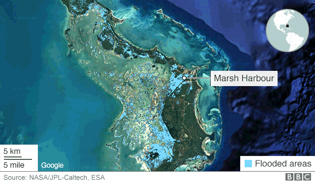
------------------------- Dora Hates You Edited: 09/05/2019 at 06:39 AM by dingpatch |
|
|
|
|
|
09/10/2019 11:41 AM
|
|
|
------------------------- Waiting for waves is ok......most people spend their lives waiting for nothing. Edited: 09/10/2019 at 11:41 AM by scostuart |
|
|
|
|
|
09/10/2019 01:08 PM
|
|
|
just read yesterday that the county will now be monitoring the beach waters for weeks to come , to track and warn of hazardous bacteria counts and contamination from all the over flowing sewage and wastewater from this disaster. some of it will potentially find its way to our coast. fyi.
|
|
|
|
|
|
09/10/2019 03:01 PM
|
|
|
Health Officials Issue "No Swim" Advisory in Brevard After Hurricane Dorian
By Krystel Knowles Brevard County PUBLISHED September 10, 2019 @3:30 PM SHARE BREVARD COUNTY, Fla. - Swimmers beware - that's what the Department of Health is advising beachgoers in Palm Beach and Brevard County post Hurricane Dorian. 'No swim' advisory issues in Palm Beach, Brevard County Officials say this is standard procedure for coastal counties Advisory will stay in place until water is tested, deemed safe According to the DOH, the 'no swim' advisory is a precaution after large events that cause turbulence in ocean waters, possible storm run-off, etc. This is a standard procedure for coastal counties. "When you get a major rain event, we have sewage discharge, we have waste water failing, storm water flushing pollutants that end up in storm drain then our water systems," said Dr. Leesa Souto, Marine Resources Council Executive Director. DOH officials do not recommend swimming in water because due to bacteria, which can cause rashes and diseases, especially if you have an open cut. Souto knows all too well what can happen when these advisories are not followed. "When I was young after the hurricanes, the weather would brighten up and (be) beautiful, and the surfers would go out in the waves, and I was one of them, I ended up getting a sinus infection and ear infection from the bacteria in the water," she explained. Brevard County resident Gary McCoury enjoys bringing Sam, his service dog, to Canova Dog Beach, but he just found out there is a 'no swimming' advisory. Since there are no lifeguard towers in Canova Dog Beach, he's planning on letting other dog owners know about the advisory. "What are you doing in the water? (There's) all kinds of stuff in there. I'll tell them word of mouth not to be in the water," McCoury said. The DOH advisory will remain in effect until the results come back from the lab to make sure there's no fecal coliform in the water, as well as enterococci bacteria. The official results will be posted on the Healthy Beaches website Wednesday morning. ------------------------- Dora Hates You |
|
|
|
|
|
09/05/2019 07:38 AM
|
|
|
abacos rely on septic tanks. Can you imagine all the pollution dumped into those reefs after this? Hope it recovers. I've been to Elbow Cay a bunch of times for surf trips. Beautiful place. but looking at the helicopter vid above it looks like it will be long time coming to rebuild there.
|
|
|
|
|
|
09/05/2019 07:43 AM
|
|
|
This is why you don't try to not evacuate for a Cat 4 or 5 storm. We got real lucky that Dorian recurved and missed Florida. Cat 5 going into the outer islands and it stalling like it did greatly reduced it's strength. All dumped (pun intended) on the upper bahamas. I've seen websites asking for donations. Please be careful of scam sites but do help out.
http://www.nbcnewyork.com/news...ahamas-559448061.html When Hurricane Dorian hit Sylvia Cottis' home at a beach club in the Bahamas, the fearsome Category 5 storm blew out the supposedly hurricane-proof windows, turning the glass into razor-sharp shrapnel that opened a wide gash on her knee. Then the 89-year-old woman and her caretaker settled in to wait for help, and conditions soon worsened. The house became flooded with sewage after the septic tank overflowed with floodwater. They could not flush the toilet without using water from a pool. Surrounded by wet belongings and filth, Cottis spent the days sitting in her wheelchair and the nights sleeping in a metal lawn lounger. Five agonizing days passed. Then on Wednesday, a neighbor and his friend at last pried opened the home's jammed door with a screwdriver to check on Cottis and 58-year-old Kathryn Cartwright. By then, her gash had become infected and swollen. |
|
|
|
|
|
09/10/2019 06:44 PM
|
|
|
Yep- that is exactly why I evacuate.. every time.
If something changed or intensified last minute, it would be too late to do anything about it. Plus, later having no A/C and no where to go is the worst. Check out 3:03 in Dave's video above. It shows one of those stilt houses, that was entirely knocked over onto its side by the wind. Insane. Suprisingly, I saw a few roofs that looked intact. But even if your house did "survive" living out there will be very hard for quite some time. This really was a worst-case scenario for Abaco Edited: 09/10/2019 at 06:50 PM by paddleout |
|
|
|
|
|
FORUMS
:
Surfing
:
Dorian named. Tracking interesting.
|
Topic Tools |
FuseTalk Basic Edition - © 1999-2024 FuseTalk Inc. All rights reserved.