
 |
2nd Light Forums |
 |
 |  |


|
Topic Title: ...DEPRESSION BECOMES TROPICAL STORM MARIA... Topic Summary: Created On: 09/16/2017 01:56 PM |
Linear : Threading : Single : Branch |
|
 Topic Tools Topic Tools
|

 09/21/2017 04:52 AM 09/21/2017 04:52 AM


|
|
|
all hype right tony? PR without power for 4-6 months and the "fake news" media made up this whole thing lol hope you don't have any family down there ------------------------- https://www.instagram.com/dj_kaye_/ |
|
|
|
|
|
09/21/2017 05:03 AM
|
|
|
more fake news http://www.chicagotribune.com/news/nationworld/ct-puerto-rico-hurricane-maria-20170921-story.html all these fake hurricanes sure seem to be making a mess of the carribean (dumb ass) ------------------------- https://www.instagram.com/dj_kaye_/ |
|
|
|
|
|
09/21/2017 05:05 AM
|
|
|
------------------------- https://www.instagram.com/dj_kaye_/ |
|
|
|
|
|
09/21/2017 09:51 AM
|
|
|
I had a friend who went to Guarabo to be with close friends and family. That's right by Caguas, where the eye went over. He is an ag student at UPR Mayaguez and has been staying at my farm to help maintain and keep the vines in check. He did fine through the storm but said it was some seriously intense shit. I have still not heard from my neighbors on whether my little tin roof wooden shack in the holler is still standing over in the Mayaguez mountainous region. Today is the anniversary of my purchase. Last year on this day, they had El Gran Apagon. The Milky Way viewing was spectacular and people kept their cool. PR is a very cohesive and mutually supportive society, especially in the countryside. The power outage last year lasted over a week and people were very calm throughout. My key set came with a Virgin Maria pendant. More than a few ironies. I still have no regret. Sure there are downsides to the society, but I have been met with open arms and blessings by each person I have met there. I look forward to moving there some day and doing everything I can to help improve the situation on the island.
Puerto Ricans are Americans, just as Virgin Islanders are Americans. I sincerely hope we show our love for them as part of our union and come to their aid. My next scheduled trip down is in November. I hope I have a home to stay in so that I can assist my neighbors anyway possible. ------------------------- If you're not part of the solution, you're part of the precipitate. |
|
|
|
|
|
09/22/2017 02:03 AM
|
|
|
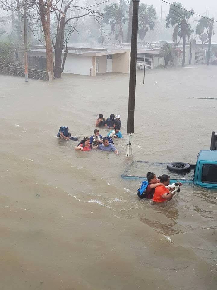
El Nuevo Día seems as good a source as any. One item from them: "12:11 p.m. -Residentes de Isabela reportan daños en el pueblo y barrio La Marina. Inundaciones en las vías principales, barrio Jobos y entrada de La Cara del Indio. Árboles y cables de energía eléctrica en el suelo. 12:11 p.m. -Residents of Isabela report damage in the town and La Marina neighborhood. Flooding in main streets, Jobos neighborhood and entranct of La Cara del Indio. Trees and electric lines on the ground. I think it may be the end for the great radio telescope in the haystack hills south of Arecibo. It's been losing funding for years and would seem unlikely to get much funding for repairs. Video from Utuado up in the mountains is discouraging. Edited: 09/22/2017 at 02:20 AM by ww |
|
|
|
|
|
09/22/2017 08:41 AM
|
|
|
I have a good friend whose family lives in Utuado. One of my favorite places in PR. Her place is high above Rio Limon, but man oh man is that river powerful!
------------------------- If you're not part of the solution, you're part of the precipitate. |
|
|
|
|
|
09/22/2017 05:21 PM
|
|
|
Guajataca Dam may fail, so 70,000 people have to evacuate. As if roads were in condition for that. Washington Post: "The dam, built by the Army Corps of Engineers in 1929, suffered a "fissure," Gov. Ricardo Rosselló said in a news conference Friday. An estimated 70,000 people in the municipalities of Quebradillas, Isabela and part of San Sebastian could be affected if the dam collapses, he said." Edited: 09/22/2017 at 05:29 PM by ww |
|
|
|
|
|
09/22/2017 09:59 PM
|
|
|
NWS National Hurricane Center Miami FL AL152017
1100 PM EDT Fri Sep 22 2017 A NOAA Hurricane Hunter plane and the Coyote unmanned aerial vehicle launched from the NOAA plane have sampled the eye and the surroundings of Maria early this evening. An Air Force plane also arrived and so far has penetrated the eye a couple of times. Based on the data from these platforms, the maximum winds are still 110 kt in the eyewall that surrounds a large eye of about 35 n mi in diameter. There are no reports of a double wind max at this time so no eyewall replacement cycle is anticipated soon. The current shear is forecast to decrease, but the hurricane is moving toward a region with less oceanic heat content. The combination of these two factors should result in a very gradual decay of the hurricane, and the NHC forecast keeps Maria as a category 3 at least for one or two more days. Satellite and plane fixes indicate that Maria is moving toward the north-northwest or 345 degrees at 8 kt, steered by a subtropical ridge to the east of the hurricane. The ridge is forecast to amplify westward during the next few days, but it is not expected to be strong enough to block the northward motion of the hurricane. It will however, force the hurricane to move slowly. Tonight's guidance continues to be in very good agreement for the next 3 days, and the NHC forecast is in the middle of the tight envelope. After that time, the GFS and EMWF are once again in competition, with the GFS defining the western edge of the guidance envelope and the ECMWF the eastern one. This makes the forecast a little more uncertain. The NHC forecast recurves Maria over the open Atlantic which is the solution of the HFIP corrected consensus and the multi-model consensus. KEY MESSAGES: 1. Swells from Maria are expected to increase along the coast of the southeastern United States and will likely cause dangerous surf and life-threatening rip currents for the next several days. 3. Maria will move between the east coast of the United States and Bermuda by the middle of next week, but it is too soon to determine what, if any, direct impacts there might be in these areas. 4. For more information on the flooding and rip current hazards in the United States, please monitor information from your local National Weather Service forecast office at www.weather.gov. FORECAST POSITIONS AND MAX WINDS INIT 23/0300Z 24.1N 71.7W 110 KT 125 MPH 12H 23/1200Z 25.3N 72.1W 110 KT 125 MPH 24H 24/0000Z 27.0N 72.4W 105 KT 120 MPH 36H 24/1200Z 28.5N 72.7W 100 KT 115 MPH 48H 25/0000Z 29.7N 72.8W 95 KT 110 MPH 72H 26/0000Z 31.7N 72.4W 85 KT 100 MPH 96H 27/0000Z 33.5N 72.3W 75 KT 85 MPH 120H 28/0000Z 35.5N 71.0W 65 KT 75 MPH |
|
|
|
|
|
09/22/2017 10:00 PM
|
|
|
Woot!
|
|
|
|
|
|
09/23/2017 04:00 AM
|
|
|
GFS run this AM suggests Outer Banks get a hit or near miss ------------------------- add a signature since I'm here in profile anyway |
|
|
|
|
|
09/23/2017 07:39 AM
|
|
|
NE bahama buoy HUUUUUGEEEE 24+ feet!
INCOMMING.... http://www.ndbc.noaa.gov/station_page.php?station=41047 |
|
|
|
|
|
09/23/2017 10:57 AM
|
|
|
Going to be interesting to see how much worse the beach erosion will be locally..... ------------------------- Waiting for waves is ok......most people spend their lives waiting for nothing. |
|
|
|
|
|
09/23/2017 05:39 PM
|
|
|
It got through the slot down south today.
|
|
|
|
|
|
09/23/2017 07:13 PM
|
|
|
Have sent a donation to the Salvation Army and would welcome info about what PR residents can use and how to get it to them. |
|
|
|
|
|
09/28/2017 03:22 AM
|
|
|
Thanks for the information.. It will surely going to help us for future purpose. |
|
|
|
|
FORUMS
:
Surfing
:
...DEPRESSION BECOMES TROPICAL STORM MARIA...
|
Topic Tools |
FuseTalk Basic Edition - © 1999-2024 FuseTalk Inc. All rights reserved.