
 |
2nd Light Forums |
 |
 |  |


|
Topic Title: ...MICHAEL BECOMES A HURRICANE AND CONTINUED STRENGTHENING EXPECTED... Topic Summary: Gulf coast Created On: 10/08/2018 09:03 AM |
Linear : Threading : Single : Branch |
|
 Topic Tools Topic Tools
|

 10/08/2018 09:03 AM 10/08/2018 09:03 AM


|
|
|
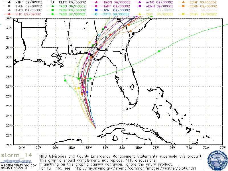
BULLETIN
Hurricane Michael Advisory Number 8 NWS National Hurricane Center Miami FL AL142018 1100 AM EDT Mon Oct 08 2018 ...MICHAEL BECOMES A HURRICANE AND CONTINUED STRENGTHENING EXPECTED... |
|
|
|
|
|
10/08/2018 09:18 AM
|
|
|
South Texas ( South Padre Island) will be the place.
http://spadre.com/surfcam.htm Wave Size: 4-6' building Wave Direction: ESE Mansfield Buoy 42020: 6' @ 8 seconds from ESE / Wind: SE @ 13-17kts link 200 Mile Buoy 42002: 6' @ 8 seconds from ESE / Wind: ESE @ 13-21kts link Dolphin Cove Buoy: Wind: SSE @ 14-18kts link Beach Driving Conditions: Poor to impassable Monday through Thursday Surf Conditions: 4-6' building choppy surf today with SSE wind at 15-20 Surf Forecast: Broad easterly fetch preceding Michael across much of the Gulf is producing a building 8 second interval ESE swell for Monday and Tuesday in the 5-6' range. Much larger 11-13 second interval swell from rapidly strengthening Hurricane Michael will begin arriving late Tuesday peaking Wednesday with well overhead to double overhead sets at the SPI jetty. Conditions on Wednesday morning at this point are looking ideal with light offshores becoming NE afternoon. Swell will decrease Thursday with light to moderate NE wind. * Surfers unfamiliar with large powerful dangerous hurricane surf should avoid the jetty Wednesday where dangerous rip currents will suck you far out to sea, and definitely do not walk out the jetty to jump off as large sets will sweep you across the rocks. Also, lifeguards are not on duty, you are on your own if you enter the surf, and Coast Guard will not enter the surf zone in their vessels. If you do happen to be in distress, wave your arms and pray one of the experienced local surfers comes to help. This swell will be the largest in years, but the entire central and upper Texas coast will also see large clean surf. Tropical Weather Outlook: Hurricane Michael rapidly strengthening to possibly a major hurricane Tuesday in the east central Gulf, headed to Florida panhandle as possibly a major cat 3 hurricane National Hurricane Center |
|
|
|
|
|
10/08/2018 11:39 AM
|
|
|
yea if you like head high maybe slightly over chunky reform chop. prob be pretty fun for a few hours tho if theres a glass off.
------------------------- sneedeker Edited: 10/08/2018 at 11:41 AM by harrietdubman |
|
|
|
|
|
10/09/2018 04:48 AM
|
|
|
Panama City is going to get Drilled!
------------------------- Dora Hates You |
|
|
|
|
|
10/09/2018 06:23 AM
|
|
|
Headed to check it out around lunch.
------------------------- Ah, religion, bigotry dressed up as morality. |
|
|
|
|
|
10/09/2018 08:42 AM
|
|
|
Let us know thanks!
|
|
|
|
|
|
10/09/2018 09:27 AM
|
|
|
Could hit as a CAT 4!
------------------------- Dora Hates You |
|
|
|
|
|
10/09/2018 06:00 PM
|
|
|
Its crazy that this coincides with king tides. This could be very bad.
------------------------- "One of the reasons why propaganda tries to get you to hate government is because it's the one existing institution in which people can participate to some extent and constrain tyrannical unaccountable power." Noam Chomsky. |
|
|
|
|
|
10/09/2018 07:23 PM
|
|
|
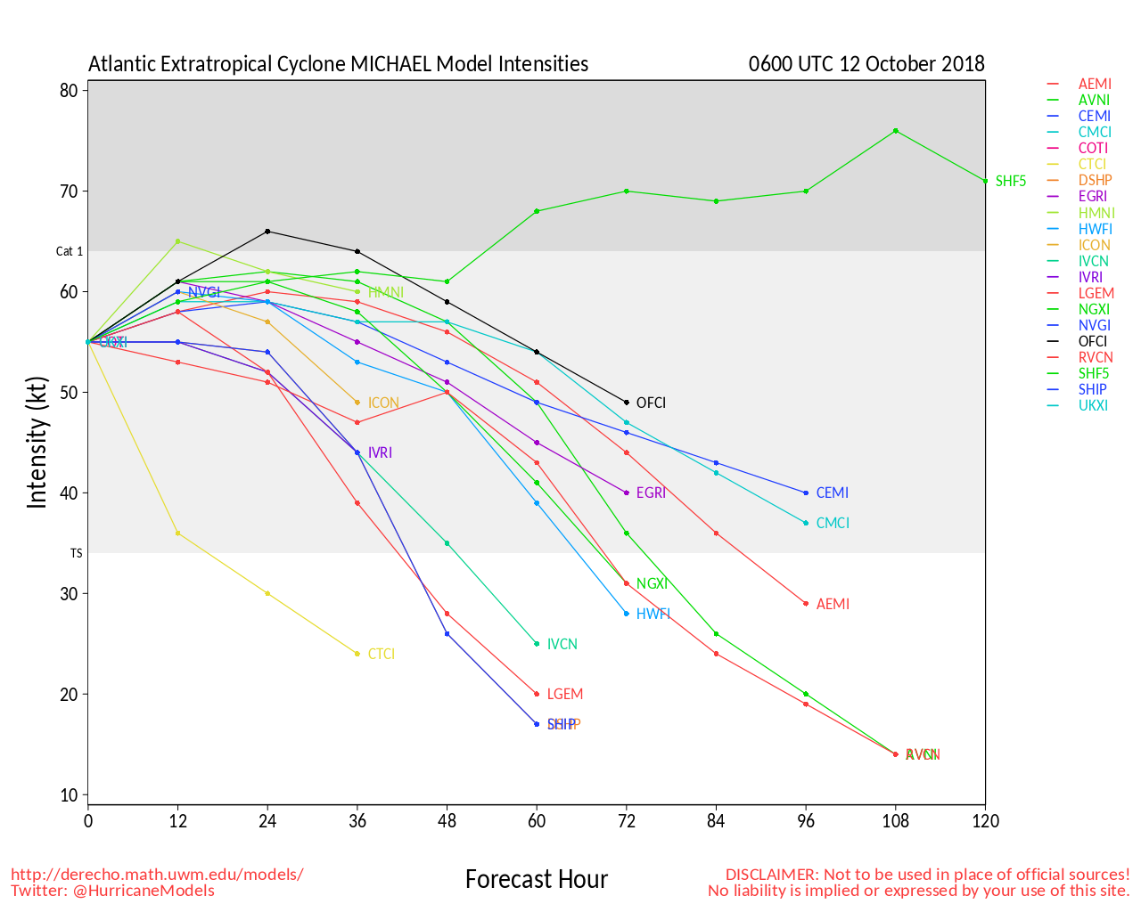
Another one jumps from 1 to major+ in less than 24 hours
|
|
|
|
|
|
10/09/2018 08:12 PM
|
|
|
|
|
|
|
|
10/10/2018 04:10 AM
|
|
|
Yikes:
Pensacola buoy - surfs up, waaaaaaaaaay up!
Forecast looks a little too big for me:
Seas 62 feet.....
That's probably computer generated heights as there may be depth and steepness limiting factors, but even at half that it's still pretty big, bad and ugly.
Praying for the panhandle
Edited: 10/10/2018 at 04:30 AM by IamSAW2 |
|
|
|
|
|
10/10/2018 04:55 AM
|
|
|
140mph reported by aircraft.
NWS National Hurricane Center Miami FL AL142018 400 AM CDT Wed Oct 10 2018 ...EXTREMELY DANGEROUS CATEGORY 4 MICHAEL STRENGTHENS FURTHER AS IT HEADS NORTHWARD TOWARD THE FLORIDA PANHANDLE... ...LIFE-THREATENING STORM SURGE...HURRICANE FORCE WINDS...AND HEAVY RAINFALL EXPECTED ALONG THE NORTHEASTERN GULF COAST... |
|
|
|
|
|
10/10/2018 04:56 AM
|
|
|
Oysters beds are going to get flushed...
|
|
|
|
|
|
10/10/2018 05:02 AM
|
|
|
|
|
|
10/10/2018 05:05 AM
|
|
|
I have a friend who lives in Panama City. He is hunkered down. I wish him well. Thanks for the radar link. Well defined eye! Ugh.
|
|
|
|
|
|
10/10/2018 05:36 AM
|
|
|
145 mph winds now too..... they aren't calling for it officially, but it has just been continuously strengthening with not much to weaken it yet. Maybe Cat 5 at landfall in a few hours?
I saw a few people make comparisons to Opal on the news this morning. While yes, it is comparable in the sense that it went from basically nothing to a major hurricane if 2 days, there is a difference in the sense that Opal drastically weakened right as it made landfall in Escambia county. Edited: 10/10/2018 at 05:39 AM by miker |
|
|
|
|
|
10/10/2018 05:45 AM
|
|
|
NHC says 145 sustained and further strengthening possible. The eye is about the size of Lake Okeechobee on latest satellite images, and can see storms growing in size around the eye. Strongest storm to ever hit that area
http://cdn.star.nesdis.noaa.go...EOCOLOR-1000x1000.gif 
Edited: 10/10/2018 at 05:49 AM by 3rdworldlover |
|
|
|
|
|
10/10/2018 05:47 AM
|
|
|
The eye of Opal went right over my house and I went out in the eye to secure a few large pieces of debris that were going to get flung back in the opposite direction once the wind changed on the other side of the eye wall. As I said, that storm was weakening as it made landfall, yet it covered the road on the barrier island with 6ft of sand from the surge/waves, there was sand completely covering the first story in some ocean front buildings, and water intrusion on the second story in most places. I was in one of the first groups that went across to the barrier island after the storm to assess the damage and I remember seeing two houses knocked off their foundations (stilts for one of them) and sitting in the middle of the bay. Also, I remember a large fishing vessel, a party boat, on the side of the road a mile inland from the marina where it was moored. Why was it so bad despite a weakening storm? The shape of the coast line and the fact that storm surge has nowhere to go.... it just stacks.
Fortunately this is a small storm in terms of wind field of the worst winds, however in the areas around where landfall occurs I am expecting total devastation. Speaking from experience with hurricanes in that area. |
|
|
|
|
|
10/10/2018 05:50 AM
|
|
|
|
|
|
10/10/2018 06:22 AM
|
|
|
Hunkering sucks.
You do it once. ------------------------- I was right. |
|
|
|
|
FORUMS
:
Surfing
:
...MICHAEL BECOMES A HURRICANE AND CONTINUED STREN...
|
Topic Tools |
FuseTalk Basic Edition - © 1999-2024 FuseTalk Inc. All rights reserved.