
 |
2nd Light Forums |
 |
 |  |


|
Topic Title: Hurricane Prediction - totally wrong Topic Summary: Created On: 07/30/2019 07:03 AM |
Linear : Threading : Single : Branch |
|
 Topic Tools Topic Tools
|

 08/05/2019 07:06 AM 08/05/2019 07:06 AM


|
|
|
Tropical cyclone formation is not expected during the next 5 days.
|
|
|
|
|
|
08/05/2019 08:00 AM
|
|
|
"The suppressed Kelvin wave that is shutting down convection over the Atlantic's main development region is predicted to bring an unfavorable environment for developing tropical cyclones. Expecting things could stay quiet until Aug 18, when another CC Kelvin wave moves in." Wunderground.com
|
|
|
|
|
|
08/05/2019 08:02 AM
|
|
|
Can you surf on Kelvin waves?
|
|
|
|
|
|
08/05/2019 08:41 AM
|
|
|
|
|
|
|
|
|
08/05/2019 08:43 AM
|
|
|
Keep Kelvin surpressed!
|
|
|
|
|
|
08/05/2019 09:38 AM
|
|
|
and here I always called it SAL....
Who the hell is calvin? and does he make waves?
|
|
|
|
|
|
08/05/2019 10:30 AM
|
|
|
Is a speeling errar. They mean Calvin.

------------------------- add a signature since I'm here in profile anyway |
|
|
|
|
|
08/05/2019 05:14 PM
|
|
|
Busted wrist.....
|
|
|
|
|
|
08/06/2019 06:04 AM
|
|
|
LOL.
virtual buoys shows a downward trend for the next Wake me up when September ends. -green day |
|
|
|
|
|
08/08/2019 08:48 AM
|
|
|
Hopefully this is a bit delayed:
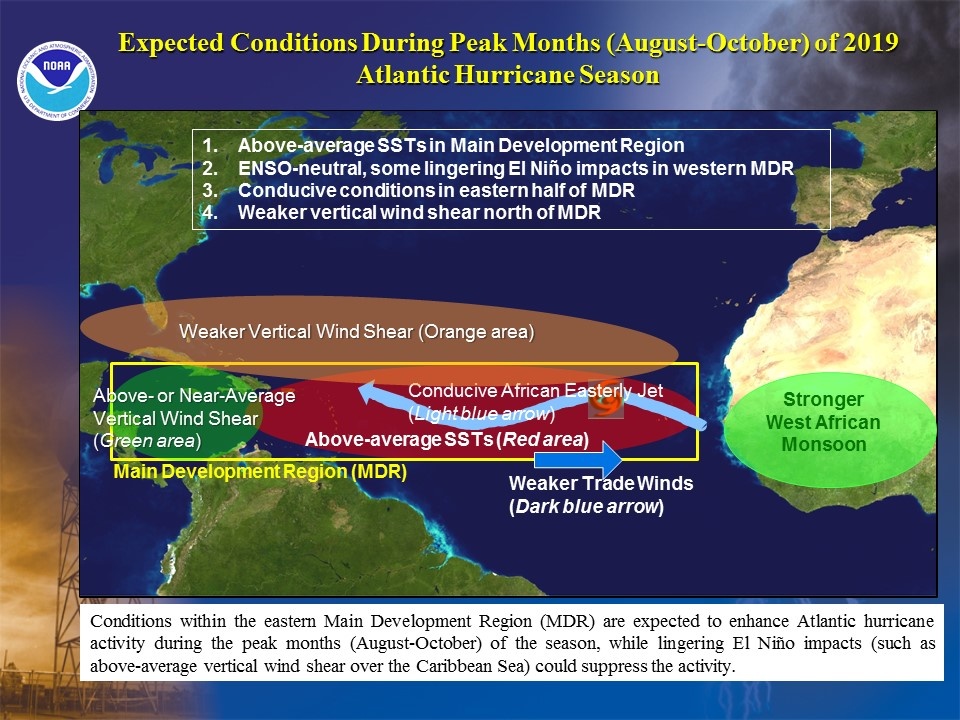
Edited: 08/08/2019 at 09:01 AM by Plan B |
|
|
|
|
|
08/08/2019 10:23 AM
|
|
|
|
|
|
08/08/2019 11:14 AM
|
|
|
That is called covering all the bases.
------------------------- Replace turf grass with native plants that don't need irrigation and synthetic fertilizers or chemicals that can go into our waterways and ocean |
|
|
|
|
|
08/09/2019 05:58 AM
|
|
|
Well... the adjustment is based on the fizzling out of El Nino. I guess we'll see how long those effects take place.... I'm hoping not for 5 more weeks
|
|
|
|
|
|
08/10/2019 06:27 AM
|
|
|
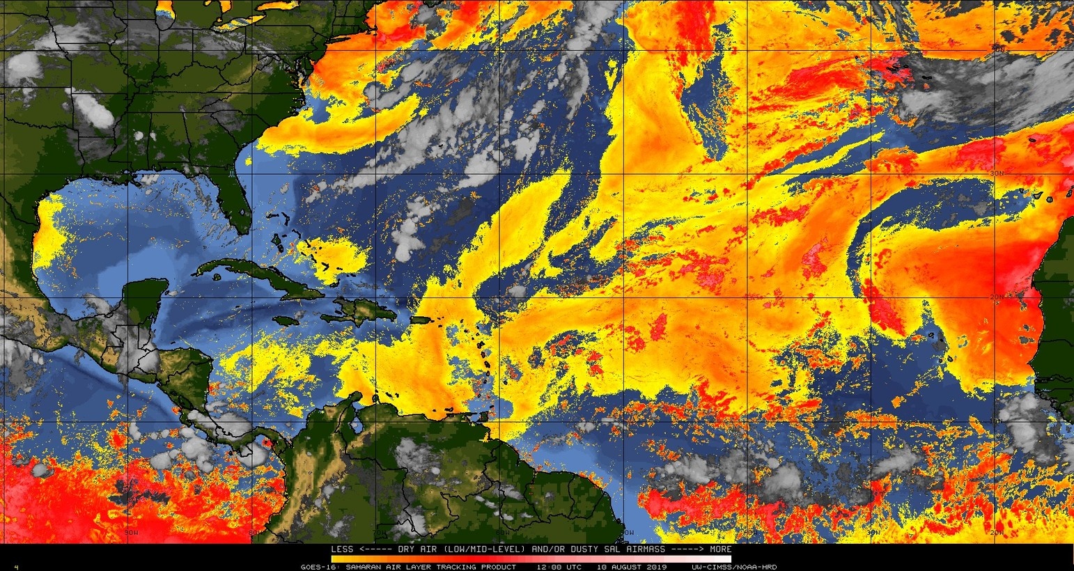
Yo SAL....
Edited: 08/10/2019 at 06:27 AM by Plan B |
|
|
|
|
|
08/13/2019 06:32 AM
|
|
 btw.... Hurricane Charley was 15 years ago today. I remember going to Panama Hatties for a hurricane party and they had 5 gal buckets everywhere for the leaking roof. Surf the next morn was the weakest head high surf of all time as it raced NE
Edited: 08/13/2019 at 06:35 AM by Plan B |
|
|
|
|
|
08/13/2019 06:38 AM
|
|
|
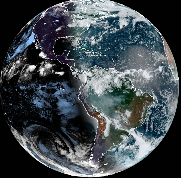
visible from space:
|
|
|
|
|
|
08/14/2019 12:04 PM
|
|
|
Anybody notice the upper level winds? Looked at a visible loop just now. Strong NE winds at the cirrus cloud altitude from here to Bermuda. Like a jet stream counter current.
------------------------- ... |
|
|
|
|
|
08/16/2019 05:59 AM
|
|
|
I think it's going to be a late start, and make up for lost time... like a hungry bear coming out of hibernation....... Hopefully wrong.... unless there's a bunch of storms just cruising around 600 miles offshore
|
|
|
|
|
|
08/16/2019 06:19 AM
|
|
|
When the big giant high pressure lifts a little north and quits suppressing the ITCZ so far south and the upper level winds relax a little, it could be like popping the cork on a shaken bottle of champagne.
------------------------- ... |
|
|
|
|
|
08/16/2019 09:57 AM
|
|
|
exactly. Hopefully it doesnt lift just north enough to create a blocking fast-track to the east coast
Edited: 08/16/2019 at 09:57 AM by Plan B |
|
|
|
|

FORUMS
:
Surfing
:
Hurricane Prediction - totally wrong
|
Topic Tools |
FuseTalk Basic Edition - © 1999-2024 FuseTalk Inc. All rights reserved.