
 |
2nd Light Forums |
 |
 |  |


|
Topic Title: TS Karen Topic Summary: Created On: 09/22/2019 05:42 AM |
Linear : Threading : Single : Branch |
|
 Topic Tools Topic Tools
|

 09/22/2019 05:42 AM 09/22/2019 05:42 AM


|
|

------------------------- Dora Hates You |
|
|
|
|
|
09/22/2019 09:02 AM
|
|
|
Way, way, too soon to be too concerned about it, , , , , , , , , , BUT, the models' westward turn on Friday/Saturday has a little bit of "pucker" factor to it.
------------------------- Dora Hates You Edited: 09/22/2019 at 01:38 PM by dingpatch |
|
|
|
|
|
09/22/2019 09:37 AM
|
|
|
no Bermuda high to speak of all summer and now the quantity and magnitude of the highs parking on the East coast are fast and furious.
|
|
|
|
|
|
09/22/2019 01:16 PM
|
|
|
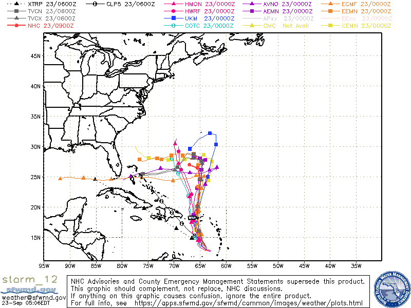
Windy shows the European model (evidently the orange line) snding Karen into Cuba as a hurricane. US model shows it sort of dissipating.
|
|
|
|
|
|
09/22/2019 04:23 PM
|
|
|
Fooking models are in pretty good agreement about Karen taking "a left"!!!! Still too soon though, , , , , ,

------------------------- Dora Hates You |
|
|
|
|
|
09/22/2019 05:29 PM
|
|
|
Way too soon, but ugly anyway.
|
|
|
|
|
|
09/22/2019 06:30 PM
|
|
|
Keep an eye on the TVCN and AVNO , two of the better models this year
|
|
|
|
|
|
09/23/2019 04:52 AM
|
|
|
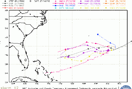
This morning's run (9/23)
------------------------- Dora Hates You |
|
|
|
|
|
09/23/2019 06:23 AM
|
|
|
"Once beyond the Caribbean the Bahamas and Florida may want to watch this and the models suggest the ridge will be strong enough after Jerry moves out to push Karen toward the west toward Florida and the Bahamas, the forecast track shows the bend west at the end. .Plenty of time to watch, but Karen has a much higher chance to be forced west than any of the other recent systems."
------------------------- Dora Hates You |
|
|
|
|
09/23/2019 06:43 AM

|
|
|
Karen moving west is better for swell making...
But... |
|
|
|
|
|
09/23/2019 07:46 AM
|
|
|
Karen is getting sheered, should be downgraded to an open wave on the 11AM update, Hurricane hunters flight path look like they are frantically searching for a center, trying to find something to keep it as a TS...I do not think this will do anything but bring rain and more SE/E winds
|
|
|
|
|
|
09/23/2019 08:15 AM
|
|
|
Tropical Storm Karen Discussion Number 6
NWS National Hurricane Center Miami FL AL122019
1100 AM AST Mon Sep 23 2019.....
"Although deep convection has recently developed near the low-level
swirl seen in early morning visible satellite imagery, the Air Force
Reserve reconnaissance aircraft that has been investigating Karen
has had difficultly finding a closed surface circulation. It is
possible that a center reformation will occur near the new
convection, so the system is still being classified as a tropical
cyclone for now. The aircraft has found believable SFMR winds of
30-35 kt over the eastern portion of the system, which still
supports an initial intensity of 35 kt. Given the current structure
of Karen and moderate to strong northeasterly shear that should
remain over the storm for the next 24 hours, no change in strength
is anticipated during that time. It is also possible that Karen
could degenerate into an open wave, if it has not done so already."
Edited: 09/23/2019 at 08:16 AM by SurferMic |
|
|
|
|
|
09/23/2019 08:43 AM
|
|
|
Until we get to Halloween I'm not counting any storm out. I thought Dorian was finished all models and NHC was about to fold and Boom.
|
|
|
|
|
|
09/23/2019 08:59 AM
|
|
|
Edited: 09/23/2019 at 09:01 AM by Plan B |
|
|
|
|
|
09/23/2019 06:13 PM
|
|
|
It's awful early but....
..... possible Lorenzo swell 
-------------------------  Puerto Rico 11 - 24 - 2013 Puerto Rico 11 - 24 - 2013
|
|
|
|
|
|
09/23/2019 06:22 PM
|
|
|
So many chances and all we get are teasers. Maybe Karen will be the one, but I am not holding my breath At least we haven't had a direct impact.
|
|
|
|
|
|
09/24/2019 06:25 AM
|
|
|
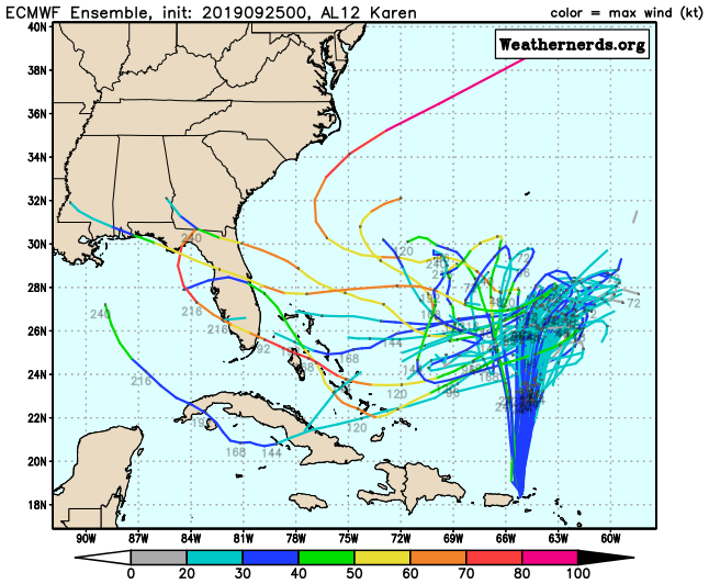
"After this it is expected to move north or just east of north for most of the week before slowing down over the weekend then moving back to the west all while remaining a tropical storm. Beyond this things still are interesting as the ridge that develops between Karen and Jerry is strong enough to push Karen westward which means Florida and the Bahamas will need to watch this system into the mid to later part of next week. As of now it looks like shear and dry air conditions will likely keep Karen on the weaker side, but intensity forecasting is very difficult"
------------------------- Dora Hates You |
|
|
|
|
|
09/24/2019 11:08 AM
|
|
|
Tuesday/2pm NHC update says still will intensify, but the afternoon model runs show it go *poof* and disappear. Hope we at least get a swell off it.
|
|
|
|
|
|
09/24/2019 12:10 PM
|
|
|
The "Spaz getti" models are trying to get a grip, , , , ,!

------------------------- Dora Hates You |
|
|
|
|
|
09/25/2019 06:16 AM
|
|
|
Is that Buh post real? LOL..... anyway........Place your bets folks! Step right up and place ya bets....
Edited: 09/25/2019 at 06:17 AM by Plan B |
|
|
|
|
FuseTalk Basic Edition - © 1999-2024 FuseTalk Inc. All rights reserved.