
 |
2nd Light Forums |
 |
 |  |


|
Topic Title: Soon to be SAM Topic Summary: Created On: 09/22/2021 02:10 PM |
Linear : Threading : Single : Branch |
|
 Topic Tools Topic Tools
|

 09/22/2021 02:10 PM 09/22/2021 02:10 PM


|
|
|
Stay away! 
|
|
|
|
|
|
09/22/2021 02:22 PM
|
|
|
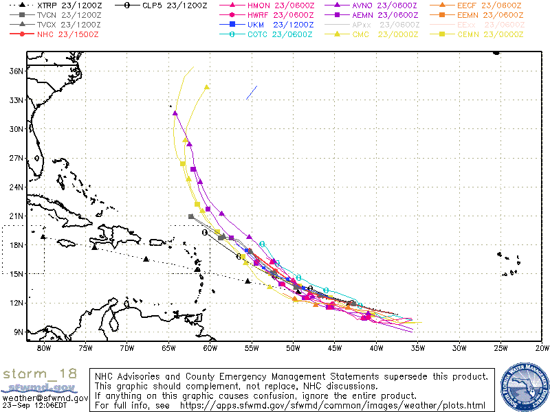
Windy's ECMWF & GFS models both have it decently offshore around next friday
http://www.windy.com/?2021100200,26.234,-69.763,5 |
|
|
|
|
|
09/22/2021 05:52 PM
|
|
|
I am Sam Sam I am.
------------------------- "One of the reasons why propaganda tries to get you to hate government is because it's the one existing institution in which people can participate to some extent and constrain tyrannical unaccountable power." Noam Chomsky. |
|
|
|
|
|
09/23/2021 04:17 AM
|
|
|
|
|
|
|
|
|
09/23/2021 07:27 AM
|
|
|
Too soon to tell but, looks like It will be well off the coast.
------------------------- Dora Hates You |
|
|
|
|
|
09/23/2021 09:47 AM
|
|
|
Tropical Storm Sam Discussion Number 4
NWS National Hurricane Center Miami FL AL182021 1100 AM AST Thu Sep 23 2021 Overnight and this morning, the satellite structure of the tropical cyclone has been improving, with prominent curved bands, and obvious low-level cloud motions that indicate the circulation is becoming established within the convection. In particular, an SSMIS microwave pass at 0653 UTC indicated a substantial improvement in the convective structure, with a well-defined curved band wrapping three-quarters of the way around the center in both the 91- and 37-GHz channels. ASCAT-B wind retrievals at 1234 UTC also indicated a tight, well-defined circulation had formed, with peak winds of 44-kt on the north side of the vortex. Subjective Dvorak satellite intensity estimates are now T3.5/55-kt from SAB and T2.5/35-kt from TAFB. In addition, the latest objective intensity estimates from UW-CIMSS ADT and SATCON were at 35-kt and 43-kt respectively. Given the recent scatterometer data, the intensity has been set to 45-kt for this advisory. Thus, Tropical Depression 18 has been upgraded to Tropical Storm Sam. It is noteworthy that this is the 2nd earliest formation of the 18th named storm in the Atlantic basin, moving ahead of the 2005 hurricane season, and only trailing last year. Sam continues to move to the west-northwest with an estimated motion at 280/14 kt. A prominent mid-level ridge remains entrenched to the north of the cyclone, and this feature should continue to steer Sam to the west-northwest over the next 2-3 days. Over this period, the ridge orientation actually shifts more westward ahead of the cyclone as a deep-layer trough digs in well northeast of Sam. This gradual change in the synoptic pattern should also result in a slowdown in Sam's forward motion over the next 72 hours. While the track guidance remains in good agreement over this period, larger spread begins to take shape beyond the day 3 forecast. Similar to yesterday, the ECMWF model and its ensemble mean flanks the southwest side of the guidance envelop, while the GFS is on the northeast side by day 5. These differences appear to be partially related to the mid-level ridge intensity on the western end, which could begin to be eroded by a mid-latitude trough off the eastern United States in 120-h. In addition, differences in both the size and intensity of Sam may also play a role in its ultimate track evolution. For this advisory, the latest NHC track forecast remains close to the consensus aids TCVN and TCVE, which represents a slight shift westward and a bit faster motion compared to the previous forecast. Because Sam is forecast to slow down, it remains too early to determine what impacts, direct or indirect, could be felt by the Lesser Antilles by this cyclone. The previously mentioned SSMIS microwave imagery also indicated that the low-level center has become better aligned with the mid-level vortex, perhaps a bit earlier than anticipated given the scatterometer data from last night. This improvement in structure, combined with favorable low vertical wind shear under 10 kt and warm 28-29 C sea-surface temperatures, argues for significant intensification. In fact, the GFS-SHIPS rapid intensification index now give Sam a 39 percent chance of a 65-kt increase over the next 72 hours, which is more than 7 times the climatological value. Thus, the NHC intensity forecast has been raised quite a bit from the prior one, especially in the short-term. The latest forecast now makes Sam a hurricane in 36 hours, and a major hurricane in 72 hours. This intensity forecast is just a shade under the latest HCCA consensus aid. Thereafter, a more gradual intensification rate is forecast. By this period it is possible that Sam could undergo hard to predict inner-core changes such as eyewall replacement cycles. In addition, the ECMWF-SHIPS suggests that the shear may also increase a little in days 4-5 which also argues for a bit slower rate of intensification for this period. FORECAST POSITIONS AND MAX WINDS INIT 23/1500Z 10.9N 38.1W 45 KT 50 MPH 12H 24/0000Z 11.3N 40.3W 50 KT 60 MPH 24H 24/1200Z 11.9N 42.9W 60 KT 70 MPH 36H 25/0000Z 12.3N 45.0W 70 KT 80 MPH 48H 25/1200Z 12.7N 46.7W 80 KT 90 MPH 60H 26/0000Z 13.2N 48.2W 90 KT 105 MPH 72H 26/1200Z 13.7N 49.4W 100 KT 115 MPH 96H 27/1200Z 15.3N 52.1W 105 KT 120 MPH 120H 28/1200Z 17.4N 55.2W 110 KT 125 MPH |
|
|
|
|
|
09/23/2021 11:16 AM
|
|
|
|
|
|
|
|
09/23/2021 05:32 PM
|
|
|
yes, waves for the alumni contest, but onshore winds will suck.
|
|
|
|
|
|
09/26/2021 05:52 AM
|
|
|
intense mini-cane..... like one of those feather weight boxers you'd rather not F-with
 Local forecast slowly improving as weather systems are slowing their roll.... we'll see
 |
|
|
|
|
|
09/26/2021 10:01 AM
|
|
|
'Tis da season. Can't wait for more hurricane surf!
|
|
|
|
|
|
09/26/2021 10:07 AM
|
|
|
NWS National Hurricane Center Miami FL AL182021
1100 AM AST Sun Sep 26 2021 ...SAM CONTINUES MOVING SLOWLY WEST-NORTHWESTWARD AS A CATEGORY 4 HURRICANE... Sam is moving toward the west-northwest, or 290/7 kt. A deep-layer subtropical ridge to the north and northeast of Sam should generally steer the hurricane west-northwestward to northwestward for the next several days. By midweek, an amplifying upper-level trough will move off the east coast of the U.S. and dig southward over the western Atlantic, which will erode the western extent of the steering ridge. The deep-layer southerly flow ahead of the trough should cause Sam to begin recurving, with a somewhat faster north-northwestward motion forecast by day 5. The latest NHC track forecast was adjusted a little to the left, or southwest of the previous official forecast, mainly at days 4 and 5, but not quite as far southwest as the model consensus aids. The hurricane will likely experience some fluctuations in intensity during the next few days. Guidance, however, indicates that the chance of an eyewall replacement cycle during the next 36 hours is below climatology. Sam will remain over warm sea-surface temperatures and in a low wind shear environment for the next 3 days, with less than 10 kt of shear diagnosed by the SHIPS guidance. It is possible that Sam's slow forward motion during the next 2 to 3 days could cause some upwelling of cooler water, but this will probably not result in significant weakening. The official NHC intensity forecast lies on the high end of the guidance for the first 36-48 h of the forecast period. Thereafter, the NHC forecast is closer to the middle of the guidance envelope. Some gradual weakening is forecast later in the period as southwesterly vertical wind shear begins to increase, but Sam is still forecast to remain a major hurricane through the 5-day period. The radii were expanded slightly by 5-10 n mi in the western semicircle from the previous advisory based on a 1155 UTC ASCAT-A pass. FORECAST POSITIONS AND MAX WINDS INIT 26/1500Z 13.9N 50.2W 125 KT 145 MPH 12H 27/0000Z 14.4N 51.2W 125 KT 145 MPH 24H 27/1200Z 15.2N 52.4W 120 KT 140 MPH 36H 28/0000Z 16.0N 53.5W 120 KT 140 MPH 48H 28/1200Z 16.8N 54.6W 115 KT 130 MPH 60H 29/0000Z 17.7N 55.7W 115 KT 130 MPH 72H 29/1200Z 18.6N 57.1W 115 KT 130 MPH 96H 30/1200Z 21.4N 60.3W 110 KT 125 MPH 120H 01/1200Z 25.6N 63.1W 110 KT 125 MPH |
|
|
|
|
|
09/27/2021 02:42 AM
|
|
|
Peter trying to reorganize near Bermuda. If it happens, can we call him RePete?
------------------------- add a signature since I'm here in profile anyway |
|
|
|
|
|
09/27/2021 11:21 AM
|
|
|
good one, tom
|
|
|
|
|
|
09/27/2021 12:50 PM
|
|
|
LOL at Repete.
Wind forecast coming up...bleh...hope it's wrong. |
|
|
|
|
|
09/27/2021 06:16 PM
|
|
|
It looks like timing going to be quick on this one: Friday building with winds OK but not great... then Saturday big but messy winds, and then maybe some leftovers on Sunday? Further north the better, probably really good outer banks, and while it's not looking like the greatest swell here I'm just glad he's not coming our way - was 150mph yesterday that's not something to mess with, phewww
------------------------- get up early and go surf - it'll make that hangover go away and/or make the workday more tolerable :) |
|
|
|
|
|
09/28/2021 06:07 AM
|
|
|
I'm gonna go with - N o the cape looking like fun surf thurs - monday
|
|
|
|
|
|
09/29/2021 09:13 AM
|
|
|
Hurricane Sam Discussion Number 28
NWS National Hurricane Center Miami FL AL182021 1100 AM AST Wed Sep 29 2021 Sam has a well-organized cloud pattern on satellite imagery, with a 90 n mi-wide Central Dense Overcast surrounded by numerous convective banding features. Upper-level outflow has now become better established to the southeast of the hurricane. A NOAA Hurricane Hunter mission from a couple of hours ago reported a 20 n mi-wide diameter circular eye. The current intensity is held at 115 kt for this advisory, which is a little higher than the maximum winds observed in the earlier aircraft mission. However, since the estimated minimum central pressure of 949 is a little lower than it was earlier this morning and Sam's intensity has been fluctuating, it is considered prudent not to lower the winds at this time. An Air Force Hurricane Hunter aircraft is scheduled to investigate the hurricane soon and will provide another intensity estimate. Sam continues its slow northwestward trek with the current motion remaining near 310/8 kt. Sam should move northwestward and then northward around the western portion of the subtropical ridge over the eastern Atlantic during the next few days, and turn toward the north-northeast and northeast later in the forecast period. The track guidance models are in very good agreement through 72 hours or so, with some increase in model spread thereafter. This increase in spread is largely due to how Sam will interact with a strong mid-latitude trough moving through Atlantic Canada. Some of the guidance suggests that this trough could partially bypass the hurricane around the end of the period and beyond, but this is not yet clear. The current NHC forecast track is not much different from the previous one and is in good agreement with the dynamical model consensus, TVCA. The hurricane will continue to move over warm waters and in an environment of low vertical shear and diffluent upper-level flow for the next 1-2 days. Thus, it would not be surprising to soon see some restrengthening. The official intensity forecast is essentially a blend of the latest Decay-SHIPS and LGEM predictions, and is very similar to the previous NHC forecast. Sam is likely to remain a major hurricane into this weekend. Key Messages: 1. Large swells generated by Sam are affecting the Leeward Islands and will spread to portions of the Virgin Islands, Puerto Rico, Hispaniola, the Bahamas, and Bermuda by Thursday or Friday. Significant swells will likely reach the east coast of the United States and Atlantic Canada by the weekend. These swells will likely cause life-threatening surf and rip current conditions, and beachgoers and other interests along these coasts are urged to follow the advice of lifeguards and local officials through the upcoming weekend. FORECAST POSITIONS AND MAX WINDS INIT 29/1500Z 19.4N 57.0W 115 KT 130 MPH 12H 30/0000Z 20.3N 58.1W 120 KT 140 MPH 24H 30/1200Z 21.8N 59.6W 120 KT 140 MPH 36H 01/0000Z 23.9N 61.0W 120 KT 140 MPH 48H 01/1200Z 26.6N 61.8W 115 KT 130 MPH 60H 02/0000Z 29.4N 61.8W 110 KT 125 MPH 72H 02/1200Z 32.0N 60.9W 105 KT 120 MPH 96H 03/1200Z 36.2N 57.3W 90 KT 105 MPH 120H 04/1200Z 39.5N 53.0W 75 KT 85 MPH |
|
|
|
|
|
09/30/2021 06:04 AM
|
|
|
<=IamTotally SkunkedThisMorningAndNowBackAtWork, ugggh, total DP failure this morning, driving all up and down looking for something worthy of getting wet and adding insult to injury the onshores (which had looked very promising last night to be hopefully light, not). Oh well it's Florida - wind waves tide - pick any one (yes we have wind)......
Edited: 09/30/2021 at 06:05 AM by IamSAW2 |
|
|
|
|
|
09/30/2021 06:29 AM
|
|
|
Winds much lighter up north. I think I'm gonna do a drive and see my folks up in N FL and surf the poles
|
|
|
|
|
|
09/30/2021 06:42 AM
|
|
|
The swell is a no show for now.
------------------------- "One of the reasons why propaganda tries to get you to hate government is because it's the one existing institution in which people can participate to some extent and constrain tyrannical unaccountable power." Noam Chomsky. |
|
|
|
|
FORUMS
:
Surfing
:
Soon to be SAM
|
Topic Tools |
FuseTalk Basic Edition - © 1999-2024 FuseTalk Inc. All rights reserved.