
 |
2nd Light Forums |
 |
 |  |


|
Topic Title: "System" sitting on top of us, , , , ,? Topic Summary: Created On: 10/08/2019 05:37 AM |
Linear : Threading : Single : Branch |
 |
- dingpatch | - 10/08/2019 05:37 AM |
|
- Cole | - 10/08/2019 07:03 PM |
|
- Plan B | - 10/09/2019 06:50 AM |
|
- SurferMic | - 10/09/2019 06:54 AM |
|
- Plan B | - 10/09/2019 06:59 AM |
|
- Plan B | - 10/09/2019 10:37 AM |
|
- StirfryMcflurry | - 10/09/2019 11:27 AM |
|
- Central Floridave | - 10/11/2019 02:01 PM |
|
- KP | - 10/11/2019 02:36 PM |
|
- Plan B | - 10/14/2019 01:19 PM |
|
- Central Floridave | - 10/15/2019 04:43 PM |
 Topic Tools Topic Tools
|

 10/08/2019 05:37 AM 10/08/2019 05:37 AM


|
|
|
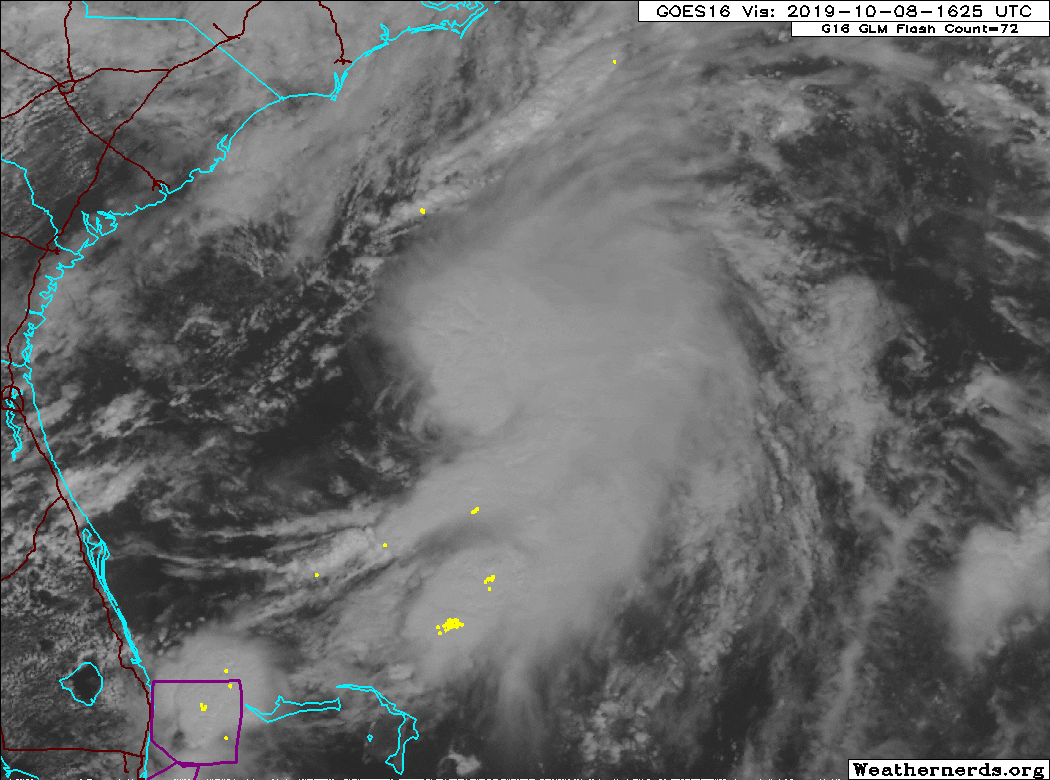
Radar shows that showers are heading West off of the ocean up in Volusia, while they are heading East away from us in Brevard, , , ,
3. A trough of low pressure extending across the southern Florida peninsula and into the southwestern Atlantic is producing disorganized showers and thunderstorms. Some slight development of this system is possible today when it moves off the southeast U.S. coast and north of the Bahamas. The disturbance is forecast to merge with a low off the east coast of the United States by Wednesday, and no further development is anticipated after that time. Regardless of development, this system is expected to produce locally heavy rainfall over portions of the the Florida peninsula during the next day or so. * Formation chance through 48 hours...low...10 percent. * Formation chance through 5 days...low...10 percent. ------------------------- Dora Hates You |
|
|
|
|
|
10/08/2019 07:03 PM
|
|
|
The thing was looping with a tail and the news never mentioned it. Well, I should say the local Fox AM affiliate didn't mention it.
------------------------- I was right. |
|
|
|
|
|
10/09/2019 06:50 AM
|
|
|
|
|
|
|
|
10/09/2019 06:54 AM
|
|
|
^^^ Nice capture of the "spin" ... this enhanced the swell mid morning and helped bring in the W/SW winds, was VERY FUN for a few hours..looks to combine with a bigger low and possible retrograde back for a day or two?...hope so..
Edited: 10/09/2019 at 06:55 AM by SurferMic |
|
|
|
|
|
10/09/2019 06:59 AM
|
|
|
That's what it looks like...... too bad it's been howling onshore up here . I'm supposed to go out of town tomm-mon so it'll prob be firing (actually to NY& Boston)
Edited: 10/09/2019 at 07:00 AM by Plan B |
|
|
|
|
|
10/09/2019 10:37 AM
|
|
|
Total OBX shadow in effect for the First Coast but......Southbound Suarez? NNE FETCH
|
|
|
|
|
|
10/09/2019 11:27 AM
|
|
|
|
|
|
|
|
|
10/11/2019 02:01 PM
|
|
|
fyi, buoys show NE long period swell
BULLETIN Subtropical Storm Melissa Advisory Number 2 NWS National Hurricane Center Miami FL AL142019 500 PM AST Fri Oct 11 2019 ...MELISSA CONTINUES TO CAUSE COASTAL FLOODING ALONG PORTIONS OF THE MID-ATLANTIC COAST AND SOUTHEASTERN NEW ENGLAND... ...THOSE IMPACTS SHOULD GRADUALLY DIMINISH TONIGHT... SUMMARY OF 500 PM AST...2100 UTC...INFORMATION ---------------------------------------------- LOCATION...38.2N 69.5W ABOUT 210 MI...335 KM S OF NANTUCKET MASSACHUSETTS MAXIMUM SUSTAINED WINDS...60 MPH...95 KM/H PRESENT MOVEMENT...SSE OR 150 DEGREES AT 3 MPH...6 KM/H MINIMUM CENTRAL PRESSURE...997 MB...29.44 INCHES WATCHES AND WARNINGS -------------------- There are no coastal tropical cyclone watches or warnings in effect. For information on wind and coastal flooding hazards, see products issued by your local National Weather Service office at weather.gov. DISCUSSION AND OUTLOOK ---------------------- At 500 PM AST (2100 UTC), the center of Subtropical Storm Melissa was located near latitude 38.2 North, longitude 69.5 West. Melissa is moving toward the south-southeast near 3 mph (6 km/h). A turn toward the east is forecast tonight followed by an increase in forward speed on Saturday. This motion will continue through Monday. On the forecast track, the center of Melissa will move away from the east coast of the United States. Maximum sustained winds are near 60 mph (95 km/h) with higher gusts. Gradual weakening is expected over the next couple of days, and Melissa is forecast to lose its subtropical characteristics by Saturday night. Winds of 40 mph extend outward up to 345 miles (555 km) from the center, primarily over waters. The estimated minimum central pressure is 997 mb (29.44 inches). HAZARDS AFFECTING LAND ---------------------- WIND: Wind gusts to 50 mph are likely to continue over portions of Cape Cod, Martha's Vineyard, and Nantucket through the early evening. COASTAL FLOODING: Coastal flooding will continue through the late evening along portions of the U.S. east coast from the mid-Atlantic states to southeastern New England. SURF: Swells generated by Melissa are affecting much of the U.S. east coast, portions of the Bahamas, Bermuda, and Atlantic Canada. These swells will result in life-threatening surf and rip current conditions. Please consult products from your local weather office. |
|
|
|
|
|
10/11/2019 02:36 PM
|
|
|
Sweet Melissa

------------------------- Time and tide wait for no one..... |
|
|
|
|
|
10/14/2019 01:19 PM
|
|
|
|
|
|
|
|
|
10/15/2019 04:43 PM
|
|
|
Well, in retrospect that was a long duration swell. Sore.
|
|
|
|
|
|
FORUMS
:
Surfing
:
"System" sitting on top of us, , , , ,?
|
Topic Tools |
FuseTalk Basic Edition - © 1999-2024 FuseTalk Inc. All rights reserved.