
 |
2nd Light Forums |
 |
 |  |


|
Topic Title: Next up Topic Summary: Created On: 08/30/2020 10:36 AM |
Linear : Threading : Single : Branch |
 |
- SurferMic | - 08/30/2020 10:36 AM |
|
- Cole | - 08/30/2020 10:41 PM |
|
- Cole | - 08/30/2020 10:45 PM |
|
- AndyH | - 08/31/2020 06:26 PM |
|
- Cole | - 08/31/2020 06:46 PM |
|
- Cole | - 08/31/2020 07:16 PM |
|
- sw | - 08/31/2020 05:20 AM |
|
- Quadro | - 08/31/2020 06:22 AM |
|
- Plan B | - 08/31/2020 08:14 AM |
|
- Plan B | - 08/31/2020 08:19 AM |
|
- StirfryMcflurry | - 08/31/2020 09:29 AM |
|
- SurferMic | - 08/31/2020 10:31 AM |
|
- jdbman | - 08/31/2020 01:56 PM |
|
- StirfryMcflurry | - 08/31/2020 03:32 PM |
|
- RocketSurf | - 08/31/2020 03:51 PM |
|
- StirfryMcflurry | - 08/31/2020 04:51 PM |
|
- fishkller | - 08/31/2020 05:49 PM |
|
- StirfryMcflurry | - 08/31/2020 02:14 PM |
|
- cheaterfiveo | - 08/31/2020 03:38 PM |
|
- StirfryMcflurry | - 08/31/2020 04:50 PM |
|
- surfmcc32 | - 08/31/2020 05:03 PM |
|
- johnnyboy | - 08/31/2020 06:54 AM |
|
- Greensleeves | - 08/31/2020 07:37 AM |
|
- chopola | - 08/31/2020 02:02 PM |
|
- RiddleMe | - 08/31/2020 06:40 PM |
|
- palmtreeg | - 08/31/2020 07:29 PM |
|
- Cole | - 09/01/2020 05:56 AM |
|
- Central Floridave | - 09/01/2020 11:31 AM |
|
- Cole | - 09/20/2020 05:11 PM |
|
- Central Floridave | - 09/01/2020 02:27 PM |
|
- Central Floridave | - 09/01/2020 02:28 PM |
|
- Plan B | - 09/02/2020 07:31 AM |
|
- RiddleMe | - 09/02/2020 08:09 AM |
|
- Plan B | - 09/02/2020 08:33 AM |
|
- RiddleMe | - 09/02/2020 09:14 AM |
|
- SurferMic | - 09/02/2020 10:20 AM |
|
- harrietdubman | - 09/02/2020 11:06 AM |
|
- Plan B | - 09/02/2020 12:03 PM |
|
- SurferMic | - 09/02/2020 02:04 PM |
|
- Plan B | - 09/03/2020 04:43 AM |
|
- ncsurf | - 09/03/2020 05:00 AM |
|
- dingpatch | - 09/03/2020 05:08 AM |
|
- Cole | - 09/03/2020 07:22 AM |
|
- SurferMic | - 09/03/2020 08:13 AM |
|
- TATTOO74 | - 09/03/2020 08:22 AM |
|
- fishkller | - 09/02/2020 02:02 PM |
 Topic Tools Topic Tools
|

 08/30/2020 10:36 AM 08/30/2020 10:36 AM


|
|||
|
North road trip not west...burning vacation time...watching...

Edited: 08/30/2020 at 10:37 AM by SurferMic
|
|||
|
|
|||
|
08/30/2020 10:41 PM
|
|||
|
Lows forming in Jacksonville. Sure, there's nothing wrong with the weather.
------------------------- I was right. |
|||
|
|
|||
|
08/30/2020 10:45 PM
|
|||
|
Chilly water and some nasty jellyfish in Cocoa Beach today.
------------------------- I was right. |
|||
|
|
|||
|
08/31/2020 06:26 PM
|
|||
|
Hey Cole, what jellyfish are out there? I've never had any reaction to jelly's, even pulled man-o-war off my leg with plenty of pain but minimal redness. Whatever I hit with the top of my foot on Friday left a serious mark. Nice red purple blob about 3" and it was a pretty intense sting. Strongest I've ever felt from a jelly.
|
|||
|
|
|||
|
08/31/2020 06:46 PM
|
|||
|
Hey Cole, what jellyfish are out there? I've never had any reaction to jelly's, even pulled man-o-war off my leg with plenty of pain but minimal redness. Whatever I hit with the top of my foot on Friday left a serious mark. Nice red purple blob about 3" and it was a pretty intense sting. Strongest I've ever felt from a jelly. It's gotten Griffin twice in Two days and they are nasty stings. What ever they are, they stay near the bottom and the are smart enough to not get washed up on shore. He said they body felt hard, as did a local girl that got hit. I really have no idea? ------------------------- I was right. |
|||
|
|
|||
|
08/31/2020 07:16 PM
|
|||
|
Three named storms before the season started. One storm formed from the Carolinas.
One has formed over Jacksonville. Two storms hit the gulf coast within five days of each other, one a Cat 4. We are at the letter M and tomorrow is September first, technically, we are just reaching the active part of hurricane season. Iowa had a storm with sustained 100 mph wind that caused $4 billion in damage. Has every one of these happened before? Yes. Have they all happened within the first half of hurricane season? Nope. ------------------------- I was right. |
|||
|
|
|||
|
08/31/2020 05:20 AM
|
|||
|
Lows forming in Jacksonville. Sure, there's nothing wrong with the weather. This particular pattern is actually not that rare at this time of the year...the low formed further west and travelled across the state pulling gulf moisture energy with it. The rain yesterday morning felt "tropical" in nature and checking the radar confirmed the counterclockwise rotation signature over north central Florida. Seems to me these happen once or twice a year around this time. |
|||
|
|
|||
|
08/31/2020 06:22 AM
|
|||
|
Clearly this is due to global climate change. No debate since lows forming off the Carolinas has never happened.
|
|||
|
|
|||
|
08/31/2020 08:14 AM
|
|||
|
|
|||
|
|
|||
|
08/31/2020 08:19 AM
|
|||
|
Models really pumped the brakes on the next 2 systems coming off Africa... we'll see
|
|||
|
|
|||
|
08/31/2020 09:29 AM
|
|||
|
Steady drizzle up here in Ocala!
|
|||
|
|
|||
|
08/31/2020 10:31 AM
|
|||
|
Not looking too good for a kick back NE swell, oh, well...shortboards going back in the rafters for at least 10 days...Time to fish
Edited: 08/31/2020 at 01:29 PM by SurferMic |
|||
|
|
|||
|
08/31/2020 01:56 PM
|
|||
|
we got a spinner TD 15
------------------------- So if you are a surfer I wish you the prosperity that allows you more time to pursue the salt water dream, and the true happiness that comes from warm water, clean waves and the companionship of your fellow surfers. If you are an internet troll just spewing bs then f off. |
|||
|
|
|||
|
08/31/2020 03:32 PM
|
|||
|
|
|||
|
|
|||
|
08/31/2020 03:51 PM
|
|||
|
Steady drizzle up here in Ocala! ^^^Man, does that explain alot.... |
|||
|
|
|||
|
08/31/2020 04:51 PM
|
|||
|
|
|||
|
|
|||
08/31/2020 05:49 PM

|
|||
|
Steady drizzle up here in Ocala! ^^^Man, does that explain alot.... YES it does LOL ------------------------- 
When America was "great" |
|||
|
|
|||
|
08/31/2020 02:14 PM
|
|||
|
|
|||
|
|
|||
|
08/31/2020 03:38 PM
|
|||
|
Lows forming in Jacksonville. Sure, there's nothing wrong with the weather. dont you remember the noname storm? |
|||
|
|
|||
|
08/31/2020 04:50 PM
|
|||
|
|
|||
|
|
|||
|
08/31/2020 05:03 PM
|
|||
|
|
|||
|
|
|||
|
08/31/2020 06:54 AM
|
|||
|
Nothing showing up for swell from magic seaweed yet.
------------------------- "One of the reasons why propaganda tries to get you to hate government is because it's the one existing institution in which people can participate to some extent and constrain tyrannical unaccountable power." Noam Chomsky. |
|||
|
|
|||
|
08/31/2020 07:37 AM
|
|||
|
Cole we got some upwelling?
|
|||
|
|
|||
|
08/31/2020 02:02 PM
|
|||
|
If we could have one stall in the north swell window. It does not happen often.. but when it does..... You know the spot.
|
|||
|
|
|||
|
08/31/2020 06:40 PM
|
|||
|
Mauve Stinger maybe?
|
|||
|
|
|||
|
08/31/2020 07:29 PM
|
|||
|
http://www.brevardtimes.com/20...n-florida-beaches/amp/
------------------------- Brevard Surf Report |
|||
|
|
|||
|
09/01/2020 05:56 AM
|
|||
|
http://www.brevardtimes.com/20...n-florida-beaches/amp/ That explains some things. Thanks Palm. ------------------------- I was right. |
|||
|
|
|||
|
09/01/2020 11:31 AM
|
|||
|
BULLETIN
Tropical Depression Fifteen Advisory Number 4 NWS National Hurricane Center Miami FL AL152020 1100 AM EDT Tue Sep 01 2020 ...TROPICAL DEPRESSION FORECAST TO MOVE FARTHER AWAY FROM LAND... SUMMARY OF 1100 AM EDT...1500 UTC...INFORMATION ----------------------------------------------- LOCATION...34.7N 73.1W ABOUT 140 MI...225 KM ESE OF CAPE HATTERAS NORTH CAROLINA MAXIMUM SUSTAINED WINDS...35 MPH...55 KM/H PRESENT MOVEMENT...ENE OR 60 DEGREES AT 14 MPH...22 KM/H MINIMUM CENTRAL PRESSURE...1008 MB...29.77 INCHES WATCHES AND WARNINGS -------------------- There are no coastal watches or warnings in effect. DISCUSSION AND OUTLOOK ---------------------- At 1100 AM EDT (1500 UTC), the center of Tropical Depression Fifteen was located near latitude 34.7 North, longitude 73.1 West. The depression is moving toward the east-northeast near 14 mph (22 km/h) This general motion is forecast today, followed by a turn toward the east by Thursday. On the forecast track, the center of the depression will continue to move away from the North Carolina coast today. Maximum sustained winds remain near 35 mph (55 km/h) with higher gusts. The depression could become a tropical storm later today or tonight. Gradual weakening is anticipated by late Wednesday. The system is forecast to become a remnant low on Thursday. The estimated minimum central pressure is 1008 mb (29.77 inches). HAZARDS AFFECTING LAND ---------------------- SURF: Swells generated by the depression will continue to affect portions of the Outer Banks of North Carolina through this evening, causing life-threatening surf and rip current conditions. Please consult products from your local weather office. |
|||
|
|
|||
|
09/20/2020 05:11 PM
|
|||
|
A spinning low forms over Lake Okeechobee and might form into Gamma once it reaches the gulf.
Yep, business as usual. lol ------------------------- I was right. |
|||
|
|
|||
|
09/01/2020 02:27 PM
|
|||
|
500 PM EDT Tue Sep 01 2020
...TROPICAL STORM OMAR FORMS BUT EXPECTED TO BE SHORT-LIVED... |
|||
|
|
|||
|
09/01/2020 02:28 PM
|
|||
|
Tropical Storm Omar Discussion Number 5
NWS National Hurricane Center Miami FL AL152020 500 PM EDT Tue Sep 01 2020 Satellite images show that the system remains sheared with a bursting pattern on satellite, occasionally exposing the center, and a large area of curved bands in the southeastern quadrant of the circulation. Almost all of the subjective and objective Dvorak estimates, along with SATCON values, are between 35 to 40 kt, and the lower number is chosen as the initial wind speed since scatterometer data suggests 30 to 35 kt. This makes Omar the 15th named storm of the 2020 Atlantic hurricane season, and is the earliest 15th storm on record, besting the previous mark by about a week from Ophelia of 2005. Any chance for strengthening should end by tomorrow afternoon due to greatly increasing shear, and weakening is likely to commence by then. The persistence of the shear should cause the cyclone to decay into a remnant low in about 48 hours, if not sooner. No significant changes were made to the previous forecast, which is near the model consensus. The initial motion remains east-northeast or 065/13 kt. The cyclone is being steered by the northern side of the subtropical ridge, which is forecast to cause a similar motion through tomorrow and an eastward turn late week due to the orientation of the ridge. The only notable change to the forecast is a slow down at long range in most of the guidance, probably due to a shallow system no longer feeling the stronger deep-layer winds, so the NHC track prediction follows suit. The remnant low should dissipate in 4-5 days. FORECAST POSITIONS AND MAX WINDS INIT 01/2100Z 35.3N 71.5W 35 KT 40 MPH 12H 02/0600Z 36.1N 69.4W 35 KT 40 MPH 24H 02/1800Z 36.7N 66.7W 35 KT 40 MPH 36H 03/0600Z 37.2N 63.9W 30 KT 35 MPH 48H 03/1800Z 37.2N 61.1W 25 KT 30 MPH...POST-TROP/REMNT LOW 60H 04/0600Z 37.0N 59.2W 25 KT 30 MPH...POST-TROP/REMNT LOW 72H 04/1800Z 37.0N 57.4W 25 KT 30 MPH...POST-TROP/REMNT LOW 96H 05/1800Z 39.5N 53.0W 25 KT 30 MPH...POST-TROP/REMNT LOW 120H 06/1800Z...DISSIPATED |
|||
|
|
|||
|
09/02/2020 07:31 AM
|
|||
|
Fairly slow start for a forecasted "record breaking " year...... does this mean the ocean is off o the races in the next couple of weeks? potentially......
|
|||
|
|
|||
|
09/02/2020 08:09 AM
|
|||
|
Slow start? We already have an 'N' storm
|
|||
|
|
|||
|
09/02/2020 08:33 AM
|
|||
|
Ha, fair enough... I guess you got a point.
|
|||
|
|
|||
|
09/02/2020 09:14 AM
|
|||
|
Definitely slow for swell
|
|||
|
|
|||
|
09/02/2020 10:20 AM
|
|||
|
NWS padding numbers, they have been doing it for years, most likely Lobbying by the giant insurance co. They want more storms total so they can say , we are raising rates due to the record number of Tropical storms...It's a scam...even a local Wx man said they should not have named Omar, It did not meet all of the requirements for a Tropical Storm!!!...Same with adding Sub-Tropical storms like Kyle, this year. Its about $$$, "Why are you raising my rates, AGAIN"--Ins. Answer. - "We had a record breaking year, just look at how many named storms there was"...And please stop naming Winter lows , that is just another ploy by big insurance to make a normal winter seem like it was extreme Winter chaos.
|
|||
|
|
|||
|
09/02/2020 11:06 AM
|
|||
|
------------------------- sneedeker |
|||
|
|
|||
|
09/02/2020 12:03 PM
|
|||
|
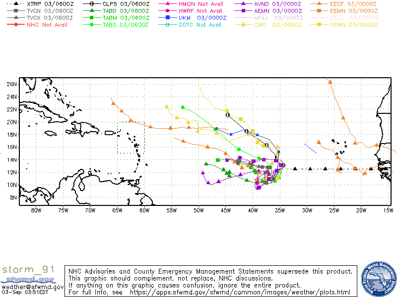
While I do agree on your premise in regards to the hype, to be fair "Omar" looks like it legitimately checks the boxes:
Edited: 09/02/2020 at 12:05 PM by Plan B |
|||
|
|
|||
|
09/02/2020 02:04 PM
|
|||
|
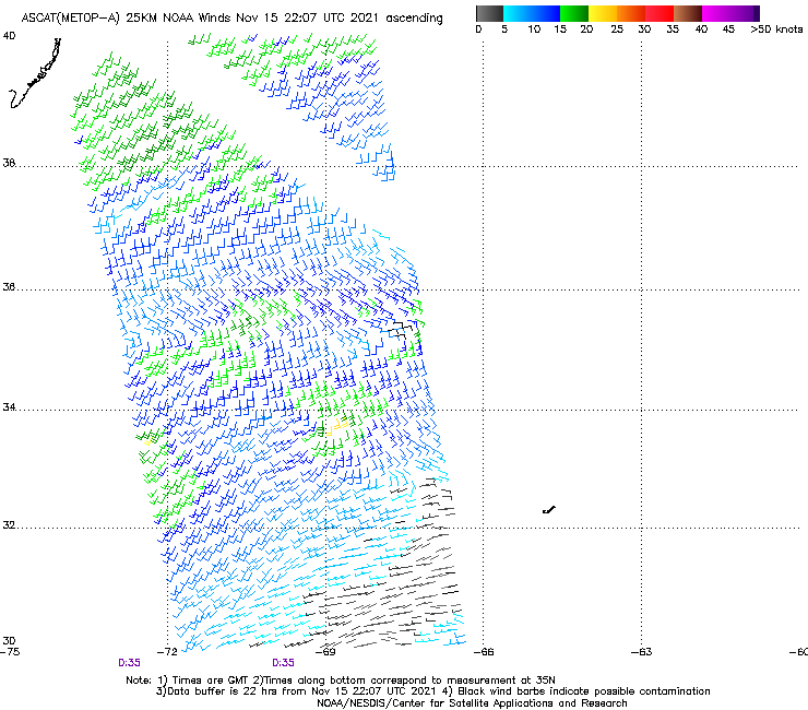
^^^ I respect your above image and comments...I guess it's splitting hairs ... AT the peak of strength, THE CENTER OF TROPICAL STORM OMAR WAS LOCATED NEAR LATITUDE
36.2 NORTH...LONGITUDE 67.4 WEST WITH MAXIMUM SUSTAINED WINDS NEAR
35 KTS...40 MPH....***Notice the NEAR 35kTS*** (35 KTS is the lowest wind speed for a TS) and those winds are only in 2 Quadrants...There was no Hurricane Hunters , this was all Model data. I don't fully buy into the naming of Omar using model data and no observations/measurements. Questionable to say the least. They need to update the classification to sustained winds of 40 mph or greater around the entire center of circulation. Yeah like that will ever happen, Hype sells and profits Ins Co's...No subtropical storms should be included IMO, it's a regular summertime low that has a cold core upper level env, Anyways , hope the next one off Africa sends waves and no destruction

Edited: 09/02/2020 at 02:31 PM by SurferMic |
|||
|
|
|||
|
09/03/2020 04:43 AM
|
|||
|
Fair enough.... but also prob not worth the $$$ to send a Hurricane hunter plane into a system like that.

Edited: 09/03/2020 at 04:43 AM by Plan B |
|||
|
|
|||
|
09/03/2020 05:00 AM
|
|||
|
|
|||
|
|
|||
|
09/03/2020 05:08 AM
|
|||
------------------------- Dora Hates You |
|||
|
|
|||
|
09/03/2020 07:22 AM
|
|||
|
My regular home owners doesn't cover hurricanes, so why do more storms make my rates go up?
I already pay extra for storm and flood, but those rates are pretty constant. As far as tropical storms, they are measured by a one minute sustained wind speed. ------------------------- I was right. |
|||
|
|
|||
|
09/03/2020 08:13 AM
|
|||
|
Good Catch ncsurf and Plan B! yeah science wins...figured someone would call me out for calling QuickScat a model (thanks for the image Plan B)
.... I would like to see the reqs for X speed for a min of Y hours be increased before they announce a name, but I doubt that will happen..rant over
Edited: 09/03/2020 at 08:27 AM by SurferMic |
|||
|
|
|||
|
09/03/2020 08:22 AM
|
|||
|
My regular home owners doesn't cover hurricanes, so why do more storms make my rates go up? I already pay extra for storm and flood, but those rates are pretty constant. As far as tropical storms, they are measured by a one minute sustained wind speed. Because you are lumped in with the rest of Florida's homeowners policies. If you don't have hurricane coverage (x-wind) how are you paying extra for "storm" coverage? Maybe PM me. |
|||
|
|
|||
|
09/02/2020 02:02 PM
|
|||
|
Always a conspiracy.. LOL -------------------------
When America was "great" |
|||
|
|
|||
FuseTalk Basic Edition - © 1999-2024 FuseTalk Inc. All rights reserved.