
 |
2nd Light Forums |
 |
 |  |


|
Topic Title: Dorian named. Tracking interesting. Topic Summary: May get sheared by the island mountains. Created On: 08/25/2019 11:41 AM |
Linear : Threading : Single : Branch |
|
 Topic Tools Topic Tools
|

 08/25/2019 11:41 AM 08/25/2019 11:41 AM


|
|
|
EDIT: took out old NHC forecast
Edited: 08/28/2019 at 04:47 AM by Central Floridave |
|
|
|
|
|
08/25/2019 04:28 PM
|
|

------------------------- Dora Hates You |
|
|
|
|
|
08/27/2019 03:35 AM
|
|
|
Tropical Storm Dorian Discussion Number 12
NWS National Hurricane Center Miami FL AL052019 500 AM AST Tue Aug 27 2019 Dorian passed over Barbados a few hours ago and it is now very near the Windward Islands. Data from the Air Force Hurricane Hunters earlier this morning suggest that the storm has held steady in intensity with a blend of the flight level and SFMR winds supporting a wind speed of 45 kt. The Caribbean composite radar data show that Dorian remains a very compact system and that it still lacks a well-defined inner core. Dry air in the mid-levels of the atmosphere around Dorian has been causing the storm to remain in a fairly steady state during the past day or so despite relatively low wind shear conditions and warm SSTs. The models show this dry air persisting in the vicinity of the system while it tracks across the Caribbean during the next day or two, so it seems likely that Dorian will continue to only gradually intensify during that time. When Dorian nears Hispaniola in 36 to 48 hours, there will likely be some increase in wind shear and those less favorable winds aloft and the interaction with the landmasses of Puerto Rico and Hispaniola should cause considerable weakening. Once the system moves north of the Greater Antilles, the environmental conditions become more favorable for intensification, and most of the intensity guidance responds by showing an increase in winds. However, there remains considerable uncertainty for this part of the forecast because the future intensity of Dorian will be quite dependent on how much land interaction there is with the mountainous island of Hispaniola. The NHC intensity forecast lies near the upper end of the guidance in the short term, while the system is over the Caribbean Sea, but near the middle of the guidance envelope after that. The storm is moving west-northwestward at 11 kt steered by a subtropical ridge to the north. This general motion should continue for another 12 to 24 hours taking Dorian across the eastern Caribbean Sea. After that time, a slight turn to the northwest is likely when the cyclone nears the eastern portion of a cut off mid- to upper-level low and moves toward a weakness in the ridge. This should take Dorian across the Dominican Republic and the Mona Passage and over the Bahamas in the 3 to 4 day time period. A ridge is likely to rebuild to the north of Dorian when it is forecast to be over the Bahamas and that could cause it to turn slightly to the left by the end of the forecast period. The new NHC track forecast is largely unchanged while Dorian is in the Caribbean, but it has been shifted slightly to the north thereafter. Users are reminded not to focus on the details of the extended track forecast as the average 5-day track error is around 200 miles. Key Messages: 1. Dorian is expected to bring tropical storm conditions to portions of the Lesser Antilles during the next several hours, where tropical storm watches and warnings are in effect. Rainfall of 3 to 6 inches is expected from Martinique to St. Vincent with isolated totals as high as 10 inches possible. 2. Tropical storm conditions are expected and hurricane conditions are possible in Puerto Rico on Wednesday, where a tropical storm warning and hurricane watch have been issued. Rainfall of 2 to 4 inches with maximum totals of 6 inches are possible across Puerto Rico and St. Croix. 3. Hurricane and Tropical Storm Watches have been issued for portions of the Dominican Republic. 4. While uncertainty remains high, wind and rain impacts are possible in the Bahamas and Florida later this week and this weekend. Residents in these areas should monitor the progress of Dorian and ensure that they have their hurricane plan in place. FORECAST POSITIONS AND MAX WINDS INIT 27/0900Z 13.5N 60.7W 45 KT 50 MPH 12H 27/1800Z 14.4N 62.3W 50 KT 60 MPH 24H 28/0600Z 15.7N 64.5W 55 KT 65 MPH 36H 28/1800Z 17.0N 66.5W 60 KT 70 MPH 48H 29/0600Z 18.5N 68.2W 60 KT 70 MPH 72H 30/0600Z 21.7N 71.4W 50 KT 60 MPH 96H 31/0600Z 24.7N 75.1W 60 KT 70 MPH 120H 01/0600Z 27.1N 79.6W 60 KT 70 MPH |
|
|
|
|
|
08/27/2019 05:31 AM
|
|
|
CFL Hurricane Dorian Lounge
And, better put your Depends on before you read this, , , , , Morning model roundup either 6z or 0z depending on the model: 6Z GFS:: Cuts over Hispaniola Thursday, clear of the Caribbean Thursday evening. Starts getting reorganized over the Central Bahamas on Saturday morning. Melbourne Landfall Sunday morning, Strong Tropical Storm. Does not reenter Gulf. 0Z Euro Clips eastern edge of Hispaniola midday Thursday, clear by the evening. Melbourne Landfall Sunday afternoon, Strong Tropical Storm. Does not reenter Gulf. 6z Legacy GFS - Landfall Puerto Rico late Wednesday afternoon, Clears the Caribbean overnight into Thursday. Strengthens to Hurricane just NE of the Turks and Caicos Thursday night. Cat 2 hurricane over Great Abaco island in the Bahamas Saturday afternoon. Landfall Melbourne, FL midday Sunday as a strong Cat 2 hurricane. Does not reenter Gulf. 0z CMC - slips through Mona passage Thursday morning, Cat 1 hurricane near Great Abaco midday Saturday. Landfall near Ft. Pierce Sunday morning as a cat 1/2 hurricane. Enters Gulf just north of Tampa late Sunday night, weak cat 1/strong TS another landfall near Carabelle, FL late Monday night. 0z NAVGEM - Clips Western side of Puerto Rico as a TS, landfall Cat 2 hurricane near Ft. Lauderdale late Sunday night. Exits into the Gulf near Sarasota by Monday night. Run ends there in the Gulf as a Cat 1. 0z Icon takes it over the eastern side of PR as a tropical Storm. Then dives it back into Cuba, end of run is a cat 1 between the Yucatan and Cuba. The 6z run of the same model keeps it in the Central Bahamas, but the run ends there. 0z HWRF takes it right over Hispaniola, it eventually recovers near the NW Bahamas, landfall strong TS/Cat 1 hurricane Melbourne, FL late Saturday night into Sunday morning. Run ends over Orlando. 0z HMON Takes it way west toward the Tiburon Peninsula of Haiti, then winds up with a strong TS/Cat 1 hurricane southwest of Andros island. 0z UKMET Takes Dorian as a Tropical Storm over the eastern side of Puerto Rico Wednesday evening. Forms into a Cat 2 hurricane near Cat Island in the Bahamas, Landfall Cat 2 hurricane near Ft. Lauderdale late Sunday night. Run ends just east of Ft. Myers inland. experimental HALFs morning run, strengthens the system east of the Bahamas, approaches E. Central Florida Monday where it explodes into a cat 4 almost 5 hurricane where the run ends east of Melbourne. ------------------------- Dora Hates You |
|
|
|
|
|
08/27/2019 07:04 AM
|
|
|
Check storm surf virtual buoy for Sept 1. Spikes to 13 feet for one day then gone. That is a direct strike.
http://stormsurf.com/cgi-bin/4cast.cgi?ID=wna.41009 |
|
|
|
|
|
08/27/2019 07:14 AM
|
|
|
That is based on the most recent GFS run.
------------------------- ... |
|
|
|
|
|
08/27/2019 07:23 AM
|
|
|
Last EURO run was in agreement with that as well..... most others are close, but with a more intense storm.
|
|
|
|
|
|
08/27/2019 06:29 PM
|
|
|
The track that skirts it through the islands and north over open water and then loop around the Bahama Bank definitely has the greatest chance to gain lots of strength due to deep, warm water. And I just had my shingles replaced, so my guess is they are not really stuck together and may just come off in chunks if it really does strengthen like they mention. sigh.
|
|
|
|
|
|
08/28/2019 03:53 AM
|
|
|
Tropical Storm Dorian Discussion Number 16
NWS National Hurricane Center Miami FL AL052019 500 AM AST Wed Aug 28 2019 Satellite images and Doppler radar data from Puerto Rico indicate that Dorian is becoming better organized with banding features now more established on the north side of the circulation. The flight-level and SFMR winds from the Air Force Hurricane Hunters were a little higher in the most recent passes through the storm, and a blend of that data supports an initial intensity of about 50 kt. The Hurricane Hunters also reported that Dorian has developed a partial eyewall and that the minimum pressure has dropped to 1003 mb. A combination of the reconnaissance data and recent ASCAT passes were used to modify the initial wind radii, and it confirms that Dorian remains a compact and asymmetric tropical storm. Dorian is moving northwestward at 11 kt toward a weakness in the ridge caused by a cut off mid- to upper-level low to the north of Hispaniola. This motion should continue for the next few days, taking Dorian across the Virgin Islands or the eastern portion of Puerto Rico later today and to the east of the Bahamas on Thursday and Friday. By late in the week, the steering pattern is expected to change as the models show a ridge building over the western Atlantic. The flow between the ridge and the aforementioned mid- to upper-level low should cause Dorian to turn west-northwestward and approach the southeast U.S. coast this weekend. The new NHC track forecast is adjusted a little to the right at most forecast times trending toward the latest consensus aids. However, there has been considerable run-to-run variability among the models so confidence in the long term track remains low. In addition, users are reminded not to focus on the exact forecast points as the average 5-day track error is around 200 miles. Some additional slow strengthening seems likely today before Dorian reaches Puerto Rico and the Virgin Islands. The land interaction could end the strengthening trend or even cause some temporary weakening, however, environmental conditions favor intensification after the storm pulls northward into the southwestern Atlantic. Nearly all of the intensity models show Dorian becoming a hurricane in about 2 days, with additional strengthening beyond that time. The NHC intensity forecast is increased from the previous one, especially at the longer forecast times, to be in better agreement with the latest models. This forecast, however, is still on the lower end of the guidance envelope, so additional upward adjustments could be needed if the guidance trends persists. It is also worth noting that the global models show Dorian increasing in size by the time it nears the southeast U.S. Key Messages: 1. Tropical storm conditions are expected in the U.S. and British Virgin Islands and Puerto Rico today, and are possible in portions of the Dominican Republic tonight and Thursday. Hurricane conditions are possible in Puerto Rico and the U.S. Virgin Islands today. 2. Heavy rainfall over portions of Puerto Rico and the U.S. and British Virgin Islands could produce flash flooding during the next couple of days. Heavy rains are expected to occur over portions of the Bahamas and Florida later this week and into early next week. 3. The threat of tropical storm or hurricane conditions, along with storm surge, in the northwestern Bahamas and along portions of the Florida east coast have increased. Residents in these areas should monitor the progress of Dorian and ensure that they have their hurricane plan in place. 4. Uncertainty in the intensity forecast late this week remains higher than usual due to a large spread in the model guidance. FORECAST POSITIONS AND MAX WINDS INIT 28/0900Z 16.8N 63.9W 50 KT 60 MPH 12H 28/1800Z 17.9N 65.3W 60 KT 70 MPH 24H 29/0600Z 19.5N 66.8W 60 KT 70 MPH 36H 29/1800Z 21.4N 68.2W 60 KT 70 MPH 48H 30/0600Z 23.3N 69.6W 65 KT 75 MPH 72H 31/0600Z 26.1N 73.0W 80 KT 90 MPH 96H 01/0600Z 27.7N 77.1W 85 KT 100 MPH 120H 02/0600Z 29.0N 80.0W 85 KT 100 MPH |
|
|
|
|
|
08/28/2019 03:56 AM
|
|
|
Tuesday afternoon model runs were trending to recurve near the Florida coast. NHC update has Dorian at 120hours off the coast of Daytona.
|
|
|
|
|
|
08/28/2019 04:24 AM
|
|
|
Gotta like what those long range models are showing this Wednesday AM. Showing to recurve and hit North Carolina.
|
|
|
|
|
|
08/28/2019 04:33 AM
|
|

------------------------- Dora Hates You |
|
|
|
|
|
08/28/2019 04:46 AM
|
|
|
Woot! Hope that recurve happens. Check the virtual buoy models, especially magic seaweeed. potential to be really good surf coming! Dorian, go visit Bermuda and leave us alone!
|
|
|
|
|
|
08/28/2019 04:58 AM
|
|
|
FUUUUUUUCK.....

|
|
|
|
|
|
08/28/2019 05:00 AM
|
|
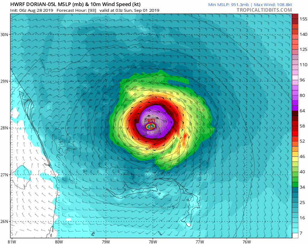 HWRF, not the best for track forcast but good with intensity
|
|
|
|
|
|
08/28/2019 05:06 AM
|
|
|
But now, after all of this back-and-forth, watch this thing get East of the Bahamas, then have the high pressure ridge really build in, and then have Dorian take a hard left into Miami as a CAT 4 with only 24 hours warning. Who does Dade County sue?
------------------------- Dora Hates You |
|
|
|
|
|
08/28/2019 06:05 AM
|
|
|
This isnt good:
|
|
|
|
|
|
08/28/2019 07:11 AM
|
|
|
growing:
|
|
|
|
|
|
08/28/2019 08:16 AM
|
|
|
Jesus.. 11am update has it pointed right at us as a MAJOR HURRICANE |
|
|
|
|
|
08/28/2019 08:20 AM
|
|
|
If you live by the water, and cant manage some serious flood control..... GORILLA TAPE is your friend. I'm going to get some now. ZIP tape is good too (prob better)... but it will make a mess of things when its time to remove
Edited: 08/28/2019 at 08:20 AM by Plan B |
|
|
|
|
FORUMS
:
Surfing
:
Dorian named. Tracking interesting.
|
Topic Tools |
FuseTalk Basic Edition - © 1999-2025 FuseTalk Inc. All rights reserved.