
 |
2nd Light Forums |
 |
 |  |


|
Topic Title: Interesting weather in the Gulf Topic Summary: Created On: 10/17/2019 10:21 AM |
Linear : Threading : Single : Branch |
 Topic Tools Topic Tools
|

 10/17/2019 10:21 AM 10/17/2019 10:21 AM


|
|
|
with what looks like a possible tropical storm and a weak cold front draped over Florida currently the weather could get interesting for us for the weekend. Hoping the low center moves off the coast enough for us to get a kick back swell. Gulf surfers prob licking their chops as well.
|
|
|
|
|
|
10/17/2019 11:09 AM
|
|
|
unfortunately I think it's just going to make for a shitty weekend...... maybe west panhandle guys get some good surf
|
|
|
|
|
|
10/17/2019 11:50 AM
|
|

------------------------- Dora Hates You |
|
|
|
|
|
10/18/2019 05:12 AM
|
|
|
Yeah for Weather!
National Weather Service Melbourne FL 445 AM EDT Fri Oct 18 2019 .DISCUSSION... ...Strong to Severe Storms Tonight into Early Saturday... ...Damaging Wind Gusts with Heavy Rains and a Few Tornadoes Possible... Today-Tonight...Weather conditions will degrade during late afternoon into tonight as an area of low pressure approaching from the central Gulf of Mexico nears the area. After a start with pleasantly cooler morning temperatures, daytime heating coupled with an increasingly moist environment will lead to the development of scattered afternoon showers and a few storms. Affected areas will see briefly heavy rains, wind gusts of 30 to 40 mph, and occasional lightning in stronger storms from mid-late afternoon. Most favored areas are from the Space Coast and Osceola County south to Lake Okeechobee, where a warm front lifts northward from S FL. expect highs in the U70s North to M80s South. The developing Gulf of Mexico low pressure center will approach the region tonight. Its important to stress regardless of any tropical development of the feature as it crosses the northeastern gulf, rapidly increasing winds locally through the atmosphere will promote a few strong to possibly severe storms. Rapidly moving storms will be capable of damaging wind gusts near 50 to 60 mph, along with a few tornadoes within a highly sheared wind environment, primarily from late tonight and into early Saturday morning. The chance of wetting rains and strong to possibly severe storms will increased markedly overnight after around 10 PM. Persons retiring for the night should ensure they have a method to receive severe weather alerts for their area through wireless device, and or NOAA weather radio. This Weekend...The GOMEX surface cyclone will move onshore the FL panhandle Sat morning, lift NE rapidly up through the SE CONUS into NC by sunrise Sun, then offshore the mid ATLC coast in the afternoon. Strong mid-upper forcing continues through mid day before pulling NE of the area late in the day. 0-1KM helicity values which start off around 100-150M2/S2 late tonight through early Sat morning will peak at 150-250M2/S2 from Brevard/Osceola Cos north during the afternoon. This supports a threat for rotating storms/tornadoes throughout much of the day, particularly across the north half CWA. POPs were kept at categorical (80-90) north and central to likely (70) south, through overall precip coverage will be decreasing during the afternoon as the low/occluded front and its parent forcing pull well away from the state. Some lingering showers possible, mainly in the evening as some mid level vort spokes rotate across the region. Isolated to scattered diurnally forced showers may redevelop Sun, mainly early, before activity wanes as drier air filters into the region. Temps L-M80s/ L-M70s on Sat, and M-U80s/U60s-L70s for Sun. Monday-Thursday...An amplifying mid-upper trough will move east from the central CONUS Mon-Tue through the eastern CONUS through mid week, temporarily flattening the SE CONUS ridge, before it rebuilds into late week. Weak surface high pressure which settles in behind the departing weekend low weakens and shifts east ahead of a cold front, which sags through ECFL Tue night. North of the front, high pressure ridge will build from the SE CONUS eastward into the western ATLC. Brief northerly post frontal wind surge will push a short lived pool of drier/cooler air across the region through Wed before winds veer quickly to NE late Wednesday and ENE-E Thursday. Lingering shower/storm chances Mon-Tue, then drying out starting Wed, with a small marine shower threat for the far south through Thu night. Above normal temps through Tue ahead of the cool front, followed by cooler (near normal) maxes Wed-Thu, but mins remaining near to above normal, especially along the coast, as winds quickly veer onshore. && .AVIATION...VFR conds are forecast through early afternoon with some clouds near FL 030 this morning. SCT showers with a few storms will develop primarily from near VRB-FPR-SUA by midday and then to northern sites of ISM-MCO-LEE this aftn into evening. Showers and brief storms may bring brief MVFR-IFR cigs NR FL020-030 along with 2- 3SM in shra with sfc wnd gusts NR 30-35kt into tonight. && .MARINE... Today-Tonight...Onshore winds early around 10 kt will veer to Sly/Se while increasing in speed by tonight. Increased winds will require an advisory mainly for winds over the waters N of Sebastian Inlet after 10 PM tonight, with caution likely over the Treasure Coast. Winds and seas will continue to diminish overnight, reaching 6 to 7 ft over the advisory area by early Saturday morning, with showers and squalls adding to the inclement conditions. Saturday-Tuesday...SCA conditions look certain for the northern and central waters through Sat-Sat night, but a little less so to the south of SIPF1. There appears to be a brief 12-hour window Sat from sunrise-sunset where gusts to gale force occur, but not entirely sure if the magnitude or frequency will be sufficient to warrant a Gale Warning. Will defer to day shift to make that call. Winds/seas quickly subside Sun as stout SW-W flow rapidly slackens behind the departing surface low. Winds and seas briefly increase again Tue ahead of the next FROPA, followed by quick wind shift and surge out of the N-NE late Tue night, which may warrant Cautionary headlines. && .PRELIMINARY POINT TEMPS/POPS... DAB 78 72 83 73 / 40 90 90 40 MCO 80 70 84 72 / 50 80 80 30 MLB 81 75 85 75 / 50 80 80 30 VRB 83 74 84 75 / 60 80 70 30 LEE 78 68 84 72 / 50 90 80 30 SFB 78 69 84 72 / 50 80 80 30 ORL 79 69 84 73 / 50 80 80 30 FPR 84 75 85 75 / 60 70 70 30 && .MLB WATCHES/WARNINGS/ADVISORIES... FL...None. AM...Small Craft Advisory from 10 PM this evening to 4 AM EDT Sunday for Flagler Beach to Volusia-Brevard County Line 0-20 nm- Flagler Beach to Volusia-Brevard County Line 20-60 nm- Volusia-Brevard County Line to Sebastian Inlet 0-20 nm- Volusia-Brevard County Line to Sebastian Inlet 20-60 nm. && $$ SHORT TERM...Pendergrast LONG TERM....Cristaldi AVIATION...Pendergrast |
|
|
|
|
|
10/18/2019 06:56 AM
|
|
|
ROAD TRIP w/ lower camping Temps at a certain state park!
|
|
|
|
|
|
10/18/2019 09:01 AM
|
|
|
Potential Tropical Cyclone Sixteen Discussion Number 5
NWS National Hurricane Center Miami FL AL162019 1000 AM CDT Fri Oct 18 2019 The satellite presentation of the system features an area of very deep convection with cloud tops colder than -80C within the eastern part of a rather broad and elongated surface circulation seen in visible satellite imagery and data from an Air Force Reserve Hurricane Hunter aircraft. A NOAA Hurricane Hunter aircraft found flight-level winds as high as 72 kt and SFMR winds of 45-50 kt southeast of the ill-defined center, and based on these data the initial intensity is set to 50 kt. The NOAA aircraft also measured a pressure of around 1001 mb. While the cyclone has deepened, the circulation is still quite elongated and not well defined, so the system is maintained as a Potential Tropical Cyclone for now. The global models continue to indicate that the circulation will consolidate and the system will strengthen some during the next 12 hours or so, as the low-level circulation will be overtaken by an upper-level trough currently situated over southwest Louisiana. The system is still expected to become a tropical or subtropical storm later today, with the exact phase dependent on the timing of the circulation improving and the interaction with the upper trough. Once the system moves inland, it should become extratropical by 36 hours and slowly weaken once it moves offshore of the Carolinas by 72-96 hours before dissipating by day 5. The new NHC intensity forecast is adjusted upward from the previous one through 24 hours based on the initial intensity and allows for the possibility of at least some additional strengthening later today. The initial motion is a somewhat uncertain 055/19 given the lack of a well-defined center. The track model guidance remains in good agreement on the system moving quickly northeastward toward the northeastern Gulf Coast during the next 24 hours as it interacts with the upper trough. After moving inland, a northeastward motion is forecast to continue until after 48 hours, when an east- northeastward motion is expected, which will take the circulation offshore over the Atlantic by 72 hours. The new NHC track forecast is similar to, but a bit to the south of the previous one and is close to the various track consensus aids. Regardless of the exact evolution of the system, portions of the northeastern coast of the Gulf of Mexico will experience strong winds, locally heavy rains, and storm surge later today and Saturday. Similar impacts are expected across portions of the Atlantic coast of the southeastern United States Saturday and Sunday. Key Messages: 1. There is a danger of life-threatening storm surge inundation of up to 5 feet above ground level beginning later today along the Florida Gulf Coast from Indian Pass to Clearwater Beach, where a Storm Surge Warning is in effect. Residents in these areas should follow advice given by local officials. 2. Tropical storm force winds are likely later today and tonight along portions of the central and eastern Gulf Coast, where tropical storm warnings are in effect. Regardless of the exact track and intensity of the system, these winds will cover a large area, especially east of the center. 3. Isolated flash flooding is possible along the central and eastern Gulf Coast and the southeast United States coast through Saturday night. 4. Wind and coastal flooding hazards along the U.S. East Coast will be covered by non-tropical watches and warnings issued by local NWS offices, since the system is expected to lose any tropical characteristics after it moves inland along the Gulf Coast. FORECAST POSITIONS AND MAX WINDS INIT 18/1500Z 25.9N 90.0W 50 KT 60 MPH...POTENTIAL TROP CYCLONE 12H 19/0000Z 27.8N 88.0W 55 KT 65 MPH...TROPICAL STORM 24H 19/1200Z 29.9N 85.5W 50 KT 60 MPH 36H 20/0000Z 32.2N 82.5W 35 KT 40 MPH...POST-TROP/EXTRATROP 48H 20/1200Z 34.4N 78.5W 35 KT 40 MPH...POST-TROP/EXTRATROP 72H 21/1200Z 37.0N 71.0W 35 KT 40 MPH...POST-TROP/EXTRATROP 96H 22/1200Z 37.0N 69.0W 25 KT 30 MPH...POST-TROP/EXTRATROP 120H 23/1200Z...DISSIPATED |
|
|
|
|
|
10/18/2019 09:28 AM
|
|
|
Hmmmmmm, , , , , the 10 o'clock reports winds of 60 MPH but, it has not yet been named?
------------------------- Dora Hates You |
|
|
|
|
|
10/18/2019 10:47 AM
|
|
|
Nestor
------------------------- So if you are a surfer I wish you the prosperity that allows you more time to pursue the salt water dream, and the true happiness that comes from warm water, clean waves and the companionship of your fellow surfers. If you are an internet troll just spewing bs then f off. |
|
|
|
|
|
10/19/2019 06:43 AM
|
|
|
NWS National Hurricane Center Miami FL AL162019
700 AM CDT Sat Oct 19 2019 ...STRONG GUSTY WINDS AND STORM SURGE AFFECTING THE COAST OF THE FLORIDA PANHANDLE... ...NESTOR STEADILY LOSING ITS TROPICAL CHARACTERISTICS... |
|
|
|
|
|
10/19/2019 06:44 AM
|
|
|
Will it go off the coast enough for us? Watcha think?
|
|
|
|
|
10/19/2019 06:59 AM

|
|
|
I am hoping for a Kyle scenario where it heads out into the Atlantic and swirls around and gives us ten days of perfect surf.
------------------------- "One of the reasons why propaganda tries to get you to hate government is because it's the one existing institution in which people can participate to some extent and constrain tyrannical unaccountable power." Noam Chomsky. |
|
|
|
|
|
10/19/2019 07:07 AM
|
|
|
Oh hell yea.....Although that may have been a once in a life time event. ------------------------- So if you are a surfer I wish you the prosperity that allows you more time to pursue the salt water dream, and the true happiness that comes from warm water, clean waves and the companionship of your fellow surfers. If you are an internet troll just spewing bs then f off. |
|
|
|
|
|
10/19/2019 07:10 AM
|
|
|
All Hail Hurr Kyle...maker of many swells...
We will probably never see that again. 5 swells I think from Kyle? |
|
|
|
|
|
10/19/2019 07:42 AM
|
|
|
|
|
|
|
|
|
10/20/2019 06:41 AM
|
|
|
2002 If you look at the tracking, even after Kyle lost tropical charateristics, it moved off Newfoundland as a super low pressure system and sent back another swell.
http://en.wikipedia.org/wiki/Hurricane_Kyle_(2002) |
|
|
|
|
|
10/20/2019 06:43 AM
|
|
|
"Lasting for a total of 22 days, Hurricane Kyle was operationally considered the third-longest-lived tropical cyclone in the Atlantic basin"
But like I said, Kyle went to the North Atlantic and went super-nova. Thus, add another week to that 22 days. We got at 5 swells from it. Look at the tracking how it did a loop-d-loop right in our swell window. |
|
|
|
|
|
10/20/2019 07:32 AM
|
|
|
|
|
|
|
|
10/21/2019 10:10 AM
|
|
|
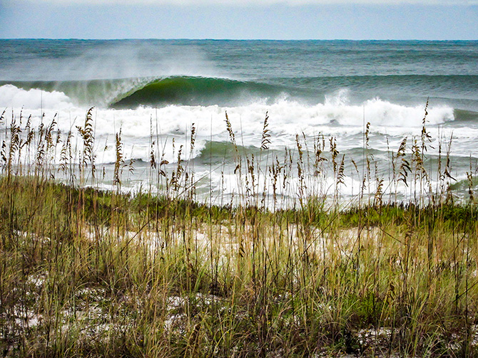
Pensacola was, apparently, pretty damn good.
Pensacola barrel
|
|
|
|
|
|
10/21/2019 10:23 AM
|
|
|
Wow.
------------------------- "One of the reasons why propaganda tries to get you to hate government is because it's the one existing institution in which people can participate to some extent and constrain tyrannical unaccountable power." Noam Chomsky. |
|
|
|
|
|
FORUMS
:
Surfing
:
Interesting weather in the Gulf
|
Topic Tools |
FuseTalk Basic Edition - © 1999-2024 FuseTalk Inc. All rights reserved.