
 |
2nd Light Forums |
 |
 |  |


|
Topic Title: Batter Up. Topic Summary: Created On: 08/11/2020 05:37 AM |
Linear : Threading : Single : Branch |
|
 Topic Tools Topic Tools
|

 08/11/2020 05:37 AM 08/11/2020 05:37 AM


|
|
|
Tropical Weather Outlook NWS National Hurricane Center Miami FL 800 AM EDT Tue Aug 11 2020 For the North Atlantic...Caribbean Sea and the Gulf of Mexico: 1. First-light visible satellite imagery shows that a better-defined center of circulation is forming in association with a low pressure system located about 900 miles west-southwest of the Cabo Verde Islands. In addition, the associated shower and thunderstorm activity has become more organized since yesterday. Environmental conditions are expected to become more conducive for additional development, and advisories could be initiated on a tropical depression as early as later today if these development trends continue. The disturbance is forecast to move west-northwestward at around 15 mph across the tropical Atlantic during the next few days, and conditions are expected to become less conducive for development by the end of the week. * Formation chance through 48 hours...high...90 percent. * Formation chance through 5 days...high...90 percent. |
|
|
|
|
|
08/11/2020 05:39 AM
|
|
|
Also long range WX models showing a possible broad low pressure off Hatteras Monday of next week.
|
|
|
|
|
|
08/11/2020 06:52 AM
|
|
|
Looks to become a TD, send us a small (but rideable pulse) before encountering some dry / harsh conditions in the Caribbean..... the GFS long range in regards to that open ocean low, just seems too good to be true. While possible, How often does that actually happen?
|
|
|
|
|
|
08/11/2020 09:41 AM
|
|
|
A Nor'easter in August 2020. Why not? Lol.
|
|
|
|
|
|
08/11/2020 12:17 PM
|
|
|
We need it. It's flat as hell out there, you'd think there was a surf contest scheduled
|
|
|
|
|
|
08/11/2020 01:33 PM
|
|
|
.....you'd think there was a surf contest scheduled Hahaha ------------------------- Time and tide wait for no one..... |
|
|
|
|
|
08/11/2020 01:49 PM
|
|
|
TD 11...hype machine ENGAGE....
#Josephine ------------------------- So if you are a surfer I wish you the prosperity that allows you more time to pursue the salt water dream, and the true happiness that comes from warm water, clean waves and the companionship of your fellow surfers. If you are an internet troll just spewing bs then f off. Edited: 08/11/2020 at 01:53 PM by jdbman |
|
|
|
|
|
08/11/2020 03:06 PM
|
|
|
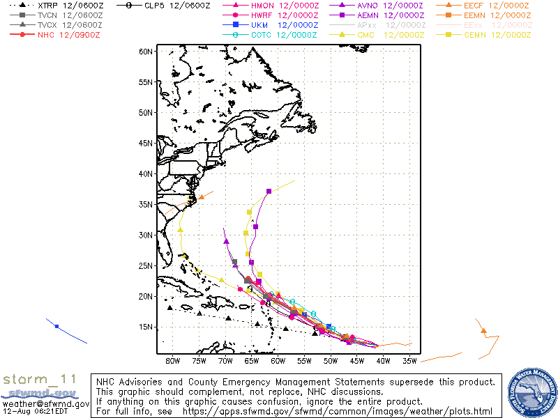
Tropical Depression Eleven Discussion Number 1
NWS National Hurricane Center Miami FL AL112020 500 PM AST Tue Aug 11 2020 Visible satellite imagery and ASCAT-C data from earlier in the day have shown that the area of low pressure NHC has been monitoring over the tropical Atlantic has developed a less-elongated circulation with a well-defined center. For the most part, deep convection has persisted with the system since about this time yesterday, save a brief period of warming cloud tops this morning. The low now meets the criteria of a tropical cyclone, and advisories have been initiated on Tropical Depression Eleven with 30-kt winds, in line with the latest Dvorak Current Intensity numbers from TAFB and SAB. The depression is moving westward, or 280/14 kt, to the south of a large mid-tropospheric high centered over the central Atlantic. This pattern is expected to evolve rather quickly, with a break developing in the ridge over the central Atlantic by 48 hours. This change should allow the depression to begin making more poleward progress, moving west-northwestward from 36 hours until the end of the forecast period. The track models are in good agreement on this scenario, as well as the system's forward speed, and bring the center of the cyclone near or just to the north of the northern Leeward Islands in 4-5 days. This first NHC forecast lies just to the north of the multi-model consensus cluster through day 3, out of respect for the northern-lying ECMWF model, and then is close to HCCA on days 4 and 5. Conventional satellite imagery and Saharan Air Layer analyses suggest that the center of the depression is being shielded from much drier air to its north and west. However, as has been the case for a few days, at least 15 kt of easterly shear has been pushing deep convection to the western side of the circulation. This shear is expected to decrease over the next day or two, which should allow for gradual strengthening to begin by 36 hours, and a peak in the cyclone's intensity should occur in about 3 days. For this period, the NHC intensity forecast is a little above HCCA and the IVCN intensity consensus. After that time, westerly or southwesterly shear is forecast to develop and increase to 20-30 kt by days 4 and 5, which is likely to induce significant weakening. In fact, it's notable that the conditions become hostile enough that the global models are showing the system opening up into a trough near the northern Leeward Islands by day 5, which is a plausible alternate scenario. FORECAST POSITIONS AND MAX WINDS INIT 11/2100Z 11.7N 40.0W 30 KT 35 MPH 12H 12/0600Z 12.0N 42.1W 30 KT 35 MPH 24H 12/1800Z 12.4N 44.5W 30 KT 35 MPH 36H 13/0600Z 13.0N 46.9W 35 KT 40 MPH 48H 13/1800Z 13.9N 49.4W 40 KT 45 MPH 60H 14/0600Z 15.1N 51.8W 45 KT 50 MPH 72H 14/1800Z 16.4N 54.3W 45 KT 50 MPH 96H 15/1800Z 18.5N 59.5W 40 KT 45 MPH 120H 16/1800Z 21.0N 64.0W 35 KT 40 MPH $$ |
|
|
|
|
|
08/12/2020 03:14 AM
|
|

|
|
|
|
|
|
08/12/2020 03:45 AM
|
|
|
Tropical Depression Eleven Discussion Number 3
NWS National Hurricane Center Miami FL AL112020 500 AM AST Wed Aug 12 2020 After an earlier burst of deep convection near the center and in the western semicircle of the circulation, overall thunderstorm activity has decreased somewhat. This is likely due to the entrainment of mid-/upper-level dry air as noted in GOES-16 high-resolution mid- and upper-level water vapor imagery, in conjunction with some modest southeasterly vertical wind shear. The latest subjective and objective Dvorak satellite classifications from TAFB/SAB and UW-CIMSS ADT of 30 kt and 33 kt, respectively, support maintaining an initial intensity of 30 kt. The depression continues moving a little north of due west, or 280/13 kt. This general motion is expected to continue through tonight due to easterly flow on the south side of a strong subtropical ridge situated to the north of the cyclone. By 24 h, all of the global models are in decent agreement that a slight weakness will develop within the ridge, allowing the cyclone to turn more toward the west-northwest and then continue that motion through the end of the forecast period. The latest NHC model guidance is tightly packed about the previous forecast track, so no significant track changes were made. The aforementioned unfavorable conditions of dry air entrainment and southeasterly shear are expected to give way to more conducive environmental conditions by 24 h when the cyclone will begin to move underneath the center of a synoptic-scale upper-level anticyclone. This will result in the shear decreasing to near zero, along with a pronounced improvement in the upper-level outflow pattern. The much lower shear conditions should also reduce the amount of dry air entrainment, while allowing for some moistening of the surrounding environment to occur. These more favorable conditions are expected to persist through at least the 60-h period, and thus slow but steady strengthening is forecast during that time. By 72 h and beyond, the global models and regional models show the system moving out from underneath the positive influence of the upper-level anticyclone, encountering moderate southerly to southwesterly vertical wind shear, which is expected to induce gradual weakening. It should be noted that during the 48-60 h period when the shear will be the lowest and sea-surface temperatures will be near 28.5C, there is a narrow window of opportunity where the intensity could peak higher than what is currently indicated. The new NHC intensity forecast is very similar to the previous advisory, and is slightly higher than the consensus intensity consensus models IVCN and HCCA due to anticipation of the very favorable low-shear conditions. FORECAST POSITIONS AND MAX WINDS INIT 12/0900Z 12.2N 42.9W 30 KT 35 MPH 12H 12/1800Z 12.6N 44.8W 35 KT 40 MPH 24H 13/0600Z 13.2N 47.3W 40 KT 45 MPH 36H 13/1800Z 14.0N 49.6W 45 KT 50 MPH 48H 14/0600Z 15.1N 52.1W 50 KT 60 MPH 60H 14/1800Z 16.3N 54.6W 50 KT 60 MPH 72H 15/0600Z 17.6N 57.0W 45 KT 50 MPH 96H 16/0600Z 20.1N 61.8W 40 KT 45 MPH 120H 17/0600Z 22.9N 65.6W 35 KT 40 MPH |
|
|
|
|
|
08/12/2020 05:00 AM
|
|
------------------------- Dora Hates You |
|
|
|
|
|
08/12/2020 08:39 AM
|
|
|
Well I am going to be optimistic about this.
------------------------- "One of the reasons why propaganda tries to get you to hate government is because it's the one existing institution in which people can participate to some extent and constrain tyrannical unaccountable power." Noam Chomsky. |
|
|
|
|
|
08/12/2020 05:52 PM
|
|
|
here we go again. yes, I too am just going to stay optimistic |
|
|
|
|
|
08/13/2020 06:13 AM
|
|
|
It stays small enough to not override our sandbars before it falls apart. It should be fun if it doesn't effect the local winds.
------------------------- I was right. |
|
|
|
|
|
08/13/2020 06:39 AM
|
|
|
Chest high... "fun" waves. Not as good as last one (at least up here)
|
|
|
|
|
|
08/13/2020 09:23 AM
|
|
|
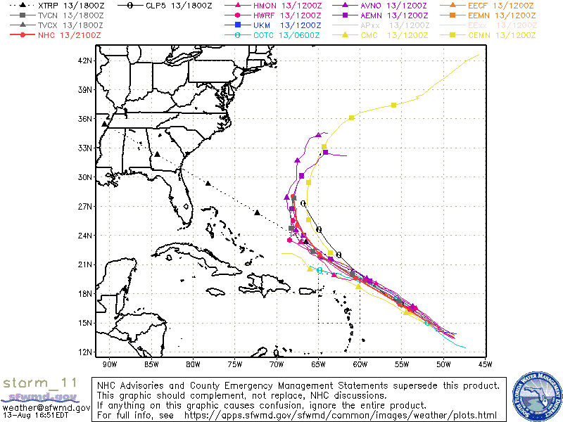
Tropical Storm Josephine Discussion Number 8
NWS National Hurricane Center Miami FL AL112020 1100 AM AST Thu Aug 13 2020 A just-received ASCAT overpass showed an area of 35-40 kt winds about 70 n mi north of the center of Tropical Depression Eleven, and based on this the cyclone is being upgraded to Tropical Storm Josephine with an initial intensity of 40 kt. Satellite imagery shows that the convective pattern associated with Josephine has become a little better organized since the last advisory, with a ragged central convective feature and a weak band in the northern semicircle. The initial motion is now west-northwestward or 295/13 kt. Josephine should continue this motion for the next several days as it moves toward a weakness in the western portion of the Atlantic subtropical ridge. The global models forecast the western end of the ridge to weaken even more after 72-96 h, which should cause the cyclone, or what is left of it by that time, to turn northwestward. The track guidance is tightly clustered, and the new forecast track lies a little to the right of the previous track and a little to the left of the consensus models. Some additional strengthening appears likely during the next 24- 36 h as Josephine moves through an environment of light vertical wind shear. After that, the cyclone is expected to encounter moderate to strong southwesterly shear as it approaches an upper-level trough over the southwestern Atlantic, which should cause at least some weakening. The new intensity forecast is adjusted upward for the first 72 h based on the current intensity. After 72 h, it shows weakening similar to the previous forecast, but not as drastic as the global models that show the storm degenerating to a tropical wave before 120 h. Josephine is the earliest tenth tropical storm of record in the Atlantic, with the next earliest tenth storm being Tropical Storm Jose on August 22, 2005. FORECAST POSITIONS AND MAX WINDS INIT 13/1500Z 13.7N 49.2W 40 KT 45 MPH 12H 14/0000Z 14.5N 51.1W 45 KT 50 MPH 24H 14/1200Z 15.8N 53.6W 50 KT 60 MPH 36H 15/0000Z 17.1N 56.3W 50 KT 60 MPH 48H 15/1200Z 18.5N 58.9W 50 KT 60 MPH 60H 16/0000Z 19.9N 61.3W 45 KT 50 MPH 72H 16/1200Z 21.3N 63.6W 40 KT 45 MPH 96H 17/1200Z 24.0N 67.0W 30 KT 35 MPH 120H 18/1200Z 27.0N 68.0W 25 KT 30 MPH |
|
|
|
|
|
08/13/2020 02:21 PM
|
|
|
Hatteras Low:
Tropical Weather Outlook NWS National Hurricane Center Miami FL 200 PM EDT Thu Aug 13 2020 For the North Atlantic...Caribbean Sea and the Gulf of Mexico: The National Hurricane Center is issuing advisories on recently upgraded Tropical Storm Josephine, located over the tropical Atlantic Ocean several hundred miles east of the Lesser Antilles. 1. A low pressure area over eastern North Carolina is expected to move east-northeastward across the north Atlantic well to the south of New England and the Canadian Maritime provinces for the next several days. This system could acquire some subtropical or tropical characteristics during the next two to three days while it moves over warm sea surface temperatures. * Formation chance through 48 hours...low...20 percent. * Formation chance through 5 days...low...30 percent. |
|
|
|
|
|
08/13/2020 02:35 PM
|
|

|
|
|
|
|
|
08/13/2020 03:22 PM
|
|

------------------------- Dora Hates You Edited: 08/13/2020 at 03:24 PM by dingpatch |
|
|
|
|
|
08/14/2020 08:19 AM
|
|
|
Weiland says the pulse hits Tuesday, waist high clean with offshores until noon in central Florida.
------------------------- "One of the reasons why propaganda tries to get you to hate government is because it's the one existing institution in which people can participate to some extent and constrain tyrannical unaccountable power." Noam Chomsky. |
|
|
|
|
FORUMS
:
Surfing
:
Batter Up.
|
Topic Tools |
FuseTalk Basic Edition - © 1999-2024 FuseTalk Inc. All rights reserved.