10/15/2020 07:07 AM
|
 Plan B
Posts: 3302
Joined Forum: 03/08/2004
|
The Fat Lady isnt singing yet. 
|
|
|
|
10/17/2020 04:58 AM
|
Plan B
Posts: 3302
Joined Forum: 03/08/2004
|
as I was saying...  That one in the open atlantic already has a solid wind rotation on the surface maps.
|
|
|
|
10/18/2020 05:04 AM
|
Plan B
Posts: 3302
Joined Forum: 03/08/2004
|
Lots of fetch pointing this way, and both GFS & EURO unusually in sync in regards to the open ocean low.  GFS ditched the carribean supercane, so hopefully we get some light wind windows (common theme this year).... could be battle of the weekend warriors next weekend. Everyone go get really drunk after work next friday
|
|
|
|
10/19/2020 01:33 PM
|
Plan B
Posts: 3302
Joined Forum: 03/08/2004
|
|
|
|
|
10/20/2020 09:57 AM
|
SurferMic
Posts: 1251
Joined Forum: 06/30/2012
|
2 days in a row of real fun/challenging HIGH TIDE mid to shore pound. You can get a chip shot in on the big ones and they are unloading in the deep shore break....King tides are good for this windswell/swell event. knee to heah-high+ and everything in between,, Pulled back on some drainers that would have snapped a board...Drift S to N today (was N-S yesterday)...so more of the Storm sets are reaching the beach...GO!!! Water is warm!
|
|
|
|
10/20/2020 10:46 AM
|
Plan B
Posts: 3302
Joined Forum: 03/08/2004
|
Yeah, I went out for a HT "lunchbreak".... wasnt dumping as hard here (too high) but some chunky ones. wind was kinda light for an hour, so I got away from the desk and got some exercise. good to loosen up before the incoming........ Biggest swell of the season may come from a tropical storm.... solid fetch. BONERS:    .
Edited: 10/20/2020 at 10:58 AM by Plan B
|
|
|
|
10/20/2020 01:51 PM
|
Plan B
Posts: 3302
Joined Forum: 03/08/2004
|
|
|
|
|
10/21/2020 05:58 AM
|
Plan B
Posts: 3302
Joined Forum: 03/08/2004
|
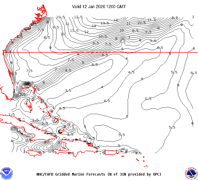
 . Detailed Wave Summary
for 41049 as of
1140 GMT on 10/21/2020:
These wave data are displayed in rounded times.
Unit of Measure:
Time Zone:
Click on the graph icon in the table below to see a time series plot of the last five days of that observation.
5-day plot - Significant Wave Height Significant Wave Height (WVHT): 17.7 ft
5-day plot - Swell Height Swell Height (SwH): 15.4 ft
5-day plot - Swell Period Swell Period (SwP): 13.8 sec 5-day plot - Swell Direction Swell Direction (SwD): ENE
Edited: 10/21/2020 at 05:59 AM by Plan B
|
|
|
|
10/21/2020 08:30 AM
|
Plan B
Posts: 3302
Joined Forum: 03/08/2004
|
41049 Swell Height Swell Height (SwH): 19.0 ft
5-day plot - Swell Period Swell Period (SwP): 13.8 sec
5-day plot - Swell Direction Swell Direction (SwD): ENE 
|
|
|
|
10/21/2020 08:43 AM
|
Plan B
Posts: 3302
Joined Forum: 03/08/2004
|

Epsilon is maintaining a healthy satellite appearance this morning
after its rapid intensification last night. A 10-to-15 n mi-wide
eye is evident in visible satellite imagery this morning, and 0815Z
GMI 89 GHz microwave imagery shows a closed eyewall with deep
convection surrounding the well-defined center. Objective satellite
estimates from UW-CIMSS and subjective Dvorak classifications from
SAB and TAFB support raising the initial intensity to 80 kt with
this advisory. An Air Force Reserve Hurricane Hunter aircraft
should be in the area this afternoon for a better estimate.
Epsilon took a brief westward jog this morning, and its initial
motion is now estimated at 285/10 kt. A mid-level ridge to the
north-northeast of the cyclone should continue steering Epsilon
toward the west-northwest today with a slightly slower forward
speed. Then, another ridge is forecast to build to the east of
the hurricane, which should turn the cyclone toward the northwest
on Thursday and northward on Friday.
Weak vertical wind shear and waters with marginal oceanic heat
content could allow for some additional modest strengthening
toda  , and the NHC intensity forecast now brings Epsilon to a 85-kt
hurricane in 12 h.
Edited: 10/21/2020 at 08:44 AM by Plan B
|
|
|
|
10/21/2020 08:44 AM
|
Cole
Posts: 68401
Joined Forum: 07/22/2003
|
Decent sets rolling in on the cams. The swell looks hard south, even at the port.
-------------------------
I was right.
|
|
|
|
10/21/2020 11:19 AM
|
SurferMic
Posts: 1251
Joined Forum: 06/30/2012
|
Hi Tide Indi Lunch report....bigger, much more energy than yesterday, Head High+ fun..but low wave count, just out-of-sync with the sets today, took a few beatings...and someone ripped off my $15 cheap black sandels at the neighborhood beach??? I hope the scumbag gets karama...Air BnBer's only ones around, now I have to hide my sandels out front? F Air BNB!
|
|
|
|
10/21/2020 11:55 AM
|
seaspray
Posts: 648
Joined Forum: 05/10/2012
|
wind hasn't been kind to us on these last couple of storm systems
|
|
|
|
10/22/2020 08:58 AM
|
surferclimber
Posts: 1356
Joined Forum: 01/23/2011
|
Originally posted by: seaspray
wind hasn't been kind to us on these last couple of storm systems
That is very true... Swell from epsilon seems to be peaking over next few days, anyone have any thoughts of when might get a little breather in these on shores??? My usual thought is dawn patrol but seems like crazy windy even when I walk dog first thing in morning
-------------------------
get up early and go surf - it'll make that hangover go away and/or make the workday more tolerable :)
|
|
|
|
10/21/2020 12:11 PM
|
Plan B
Posts: 3302
Joined Forum: 03/08/2004
|
Originally posted by: SurferMic
Hi Tide Indi Lunch report....bigger, much more energy than yesterday, Head High+ fun..but low wave count, just out-of-sync with the sets today, took a few beatings...and someone ripped off my $15 cheap black sandels at the neighborhood beach??? I hope the scumbag gets karama...Air BnBer's only ones around, now I have to hide my sandels out front? F Air BNB!
HA. Sounds like my quick lunchbreak session.... pleasantly surprised, but hard to get many waves in under an hour. sorry about your slaps.... 110 and moving WNW at 9... YEWWWW
|
|
|
|
10/21/2020 12:42 PM
|
ww
Posts: 16097
Joined Forum: 08/17/2007
|
Washington Post (they have good weather coverage):
On Tuesday morning, Epsilon was a 45 mph tropical storm; by early Wednesday, it had morphed into a Category 1 hurricane with 90 mph winds. It surprised meteorologists when it intensified into a high-end Category 2 hurricane with 110 mph winds early Wednesday afternoon, with a chance that it will reach major hurricane status as a Category 3.
That significantly exceeds the criterion for "rapid intensification" of 35 mph or more in 24 hours. Epsilon jumped at least 50 mph in that same time frame .
|
|
|
|
10/22/2020 04:24 AM
|
Plan B
Posts: 3302
Joined Forum: 03/08/2004
|
Hoping we SCORE this weekend, cuz I'm Kinda wishing I made the mega-trek to OBX rt now.
|
|
|
|
10/22/2020 04:26 AM
|
Plan B
Posts: 3302
Joined Forum: 03/08/2004
|
Getting closer. NW BAHAMA BUOY: 41047 as of (6:40 am EDT)
1040 GMT on 10/22/2020:
5-day plot - Significant Wave Height Significant Wave Height (WVHT): 10.8 ft
5-day plot - Swell Height Swell Height (SwH): 10.2 ft
5-day plot - Swell Period Swell Period (SwP): 14.8 sec
5-day plot - Swell Direction Swell Direction (SwD): E
|
|
|
|
10/22/2020 07:13 AM
|
Cole
Posts: 68401
Joined Forum: 07/22/2003
|
The 20 miler is 8.2 at 11. Swell certainly isn't a problem.
Loving the east wind.
-------------------------
I was right.
|
|
|
|


 Topic Tools