
 |
2nd Light Forums |
 |
 |  |


|
Topic Title: Tropical Depression off of Hatteras. Topic Summary: Created On: 06/14/2021 08:05 AM |
Linear : Threading : Single : Branch |
 Topic Tools Topic Tools
|

 06/14/2021 08:05 AM 06/14/2021 08:05 AM


|
|
|
Tropical Depression Two Advisory Number 1
NWS National Hurricane Center Miami FL AL022021 1100 AM EDT Mon Jun 14 2021 ...TROPICAL DEPRESSION FORMS OFFSHORE OF NORTH CAROLINA... ...HEADING AWAY FROM THE UNITED STATES... SUMMARY OF 1100 AM EDT...1500 UTC...INFORMATION ----------------------------------------------- LOCATION...35.0N 73.7W ABOUT 105 MI...165 KM E OF CAPE HATTERAS NORTH CAROLINA MAXIMUM SUSTAINED WINDS...35 MPH...55 KM/H PRESENT MOVEMENT...NE OR 50 DEGREES AT 21 MPH...33 KM/H MINIMUM CENTRAL PRESSURE...1006 MB...29.71 INCHES WATCHES AND WARNINGS -------------------- There are no coastal watches or warnings in effect. DISCUSSION AND OUTLOOK ---------------------- At 1100 AM EDT (1500 UTC), the center of Tropical Depression Two was located near latitude 35.0 North, longitude 73.7 West. The depression is moving toward the northeast near 21 mph (33 km/h), and this general motion is expected through Wednesday with increasing forward speed. Maximum sustained winds are near 35 mph (55 km/h) with higher gusts. The depression is expected to become a tropical storm by tonight and could continue to strengthen on Tuesday. The system should begin to weaken by Tuesday night and is expected to dissipate on Wednesday. The estimated minimum central pressure is 1006 mb (29.71 inches). |
|
|
|
|
|
06/14/2021 08:07 AM
|
|
|
TBD if a swell maker for us, probably not...but, ya never know...
Tropical Depression Two Discussion Number 1 NWS National Hurricane Center Miami FL AL022021 1100 AM EDT Mon Jun 14 2021 Satellite and radar images show that the low pressure area that NHC has been following since yesterday off the coast of North Carolina has become better organized, with a small central dense overcast over the center and more prominent banding features. The low also has advanced ahead of a nearby diffuse stationary front, with that boundary lying northwest of the center. Considering the small core of the low, ample deep convection, satellite pattern, and that the low is feeding off of the thunderstorm activity (and not the front) -- it is now classified as a tropical depression. The initial intensity is set to 30 kt, which is our best estimate assuming strengthening from the 20-25 kt overnight ASCAT and surface observations. The depression is moving northeastward at about 18 kt. A large mid-latitude trough digging across eastern North America should cause the cyclone to continue moving generally northeastward, but faster, over the next couple of days. In about 48 hours, the system is forecast to dissipate near Newfoundland as it is absorbed by a larger extratropical low. Model guidance is in very good agreement on this scenario, and the NHC forecast lies near the track consensus. The depression has about 24 hours over marginally warm waters in low-to-moderate shear to strengthen before it moves north of the Gulf Stream and decays. Almost all of the intensity guidance shows the system becoming a tropical storm tonight, and considering the healthy initial structure, the official forecast follows that guidance. The low should lose tropical characteristics in about 36 hours due to very cold waters and dissipate near Newfoundland in about 2 days. FORECAST POSITIONS AND MAX WINDS INIT 14/1500Z 35.0N 73.7W 30 KT 35 MPH 12H 15/0000Z 36.6N 70.9W 40 KT 45 MPH 24H 15/1200Z 39.8N 65.3W 45 KT 50 MPH 36H 16/0000Z 43.6N 59.7W 40 KT 45 MPH...POST-TROP/EXTRATROP 48H 16/1200Z...DISSIPATED |
|
|
|
|
|
06/14/2021 08:37 AM
|
|
|
Come on.....come on baby.....
Sit out there for week or 2 give us the goods and then head out to the North Atlantic  make funny GIFs like this at MakeaGif
------------------------- Time and tide wait for no one..... Edited: 06/14/2021 at 08:48 AM by KP |
|
|
|
|
|
06/14/2021 10:21 AM
|
|

|
|
|
|
|
|
06/14/2021 07:54 PM
|
|
|
Tropical Storm Bill Advisory Number 3
NWS National Hurricane Center Miami FL AL022021 1100 PM AST Mon Jun 14 2021 ...DEPRESSION STRENGTHENS INTO TROPICAL STORM BILL... ...LIKELY TO BE SHORT-LIVED... SUMMARY OF 1100 PM AST...0300 UTC...INFORMATION ----------------------------------------------- LOCATION...36.7N 69.8W ABOUT 335 MI...540 KM ENE OF CAPE HATTERAS NORTH CAROLINA MAXIMUM SUSTAINED WINDS...45 MPH...75 KM/H PRESENT MOVEMENT...NE OR 55 DEGREES AT 23 MPH...37 KM/H MINIMUM CENTRAL PRESSURE...1003 MB...29.62 INCHES WATCHES AND WARNINGS -------------------- There are no coastal watches or warnings in effect. DISCUSSION AND OUTLOOK ---------------------- At 1100 PM AST (0300 UTC), the center of Tropical Storm Bill was located near latitude 36.7 North, longitude 69.8 West. Bill is moving toward the northeast near 23 mph (37 km/h), and this general motion is expected through Wednesday with increasing forward speed. Satellite-derived wind data indicate that the maximum sustained winds have increased to near 45 mph (75 km/h) with higher gusts. Some additional strengthening is possible on Tuesday, however the system is expected to become a post-tropical low and dissipate on Wednesday. Tropical-storm-force winds extend outward up to 70 miles (110 km) from the center. The estimated minimum central pressure is 1003 mb (29.62 inches). |
|
|
|
|
|
06/15/2021 05:21 AM
|
|
|
Last Bill swell Tom Neilson and I cracked Monster Hole in the morning, going out with the current with the stars still out in the pre-dawn sky. Scored to say the least. Then on the way home stopped at no-club and Sunrise bro-ed me with some photos. Melody capped on my surfing like any good surfer would... Thanks Sunrise, good to see you at the Waterman's Challenge you were surfing good, Melody of course too! So fun!
SO Bill with all it's waves didn't hurt anyone last time... A good omen. 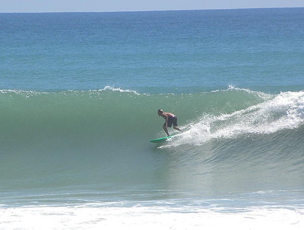

Edited: 06/15/2021 at 05:43 AM by Greensleeves |
|
|
|
|
|
06/15/2021 05:30 AM
|
|
|
Last Bill swell Tom Neilson and I cracked Monster Hole in the morning, going out with the current with the stars still out in the pre-dawn sky. Scored to say the least. Then on the way home stopped at no-club and Sunrise bro-ed me with some photos. Melody capped on my surfing like any good surfer would... Thanks Sunrise, good to see you at the Waterman's Challenge you were surfing good, Melody of course too! So fun! SO Bill with all it's waves didn't hurt anyone last time... A good omen. epic^^!! Monster Hole paddle creeps me out, pre dawn- yikes, bet the adrenaline was pumping as hard as the surf! ------------------------- I troll 2L.com to be a better person in real life |
|
|
|
|
|
06/15/2021 05:57 AM
|
|
|
That's a day. A great day.
------------------------- "One of the reasons why propaganda tries to get you to hate government is because it's the one existing institution in which people can participate to some extent and constrain tyrannical unaccountable power." Noam Chomsky. |
|
|
|
|
|
06/15/2021 08:29 AM
|
|
|
Yes Pandaroo! Figured you love it there! I lost my board on a bomb and yelled at Tom "I'm swimming forever, see you in 30 minutes maybe". Swam in about 50 yards and some kid had grabbed it! He was getting battered and once I got it from him and said "biggest thanks follow me out to the channel on the right" I didn't see him again. Surfers!!
|
|
|
|
|
|
06/15/2021 09:12 AM
|
|
|
Unfortunately, no wind fetch pointed back at us. Oh well...Bill flared up with no warning in the long range models.
https://earth.nullschool.net/#...584/loc=-74.839,27.535 |
|
|
|
|
|
06/15/2021 09:15 AM
|
|
|
Bill got up to 60mph. That is some flare up. from nothing to 60 in 24 hours.
Tropical Storm Bill Advisory Number 5 NWS National Hurricane Center Miami FL AL022021 1100 AM AST Tue Jun 15 2021 ...BILL RACING NORTHEASTWARD... ...EXPECTED TO BECOME EXTRATROPICAL LATER TODAY... SUMMARY OF 1100 AM AST...1500 UTC...INFORMATION ----------------------------------------------- LOCATION...40.5N 62.0W ABOUT 295 MI...475 KM SSE OF HALIFAX NOVA SCOTIA ABOUT 420 MI...675 KM E OF NANTUCKET MASSACHUSETTS MAXIMUM SUSTAINED WINDS...60 MPH...95 KM/H PRESENT MOVEMENT...NE OR 55 DEGREES AT 38 MPH...61 KM/H MINIMUM CENTRAL PRESSURE...998 MB...29.47 INCHES WATCHES AND WARNINGS -------------------- There are no coastal watches or warnings in effect. DISCUSSION AND OUTLOOK ---------------------- At 1100 AM AST (1500 UTC), the center of Tropical Storm Bill was located near latitude 40.5 North, longitude 62.0 West. Bill is moving very quickly to the northeast near 38 mph (61 km/h) and a continued fast northeastward motion is expected through Wednesday. Maximum sustained winds are near 60 mph (95 km/h) with higher gusts. Little change in strength is expected today, but Bill is forecast to become a post-tropical low by this evening and dissipate on Wednesday. Tropical-storm-force winds extend outward up to 90 miles (150 km) from the center. The estimated minimum central pressure is 998 mb (29.47 inches). |
|
|
|
|
|
06/15/2021 02:36 PM
|
|
|
It looks like spots north of us got a little pulse, not the complete and utter flatness we are seeing here
|
|
|
|
|
|
FORUMS
:
Surfing
:
Tropical Depression off of Hatteras.
|
Topic Tools |
FuseTalk Basic Edition - © 1999-2024 FuseTalk Inc. All rights reserved.