
 |
2nd Light Forums |
 |
 |  |


|
Topic Title: Fred. Our next hope. Topic Summary: Picture me rolling! Created On: 08/30/2015 06:04 AM |
Linear : Threading : Single : Branch |
 Topic Tools Topic Tools
|

 08/30/2015 06:04 AM 08/30/2015 06:04 AM


|
|
|
Something to believe in. |
|
|
|
|
|
08/30/2015 07:35 AM
|
|
|
TROPICAL STORM FRED DISCUSSION NUMBER 2
NWS NATIONAL HURRICANE CENTER MIAMI FL AL062015 500 AM AST SUN AUG 30 2015 The convective cloud pattern of the tropical cyclone has continued to improve this early morning with the development of a small CDO feature and a tightly curved band in the western and southern quadrants. A 0542 UTC SSMI/S microwave satellite image further indicated that the convective band wraps almost completely around a primitive mid-level eye feature. The initial intensity is raised to 35 kt based on a Dvorak classification of T2.5/35 kt from TAFB, and this intensity could be conservative based on the impressive SSMI/S satellite signature. This makes Fred only the fourth Atlantic tropical storm to form east of 19W longitude in NHC's database. The initial motion remains 305/10 kt. There is no change to the previous forecast track reasoning. Fred is expected to move northwestward toward a weakness just northwest of the Cape Verde Islands within a deep-layer subtropical ridge. The mid-tropospheric trough that is responsible for the weakness is forecast by the global and regional models to shift eastward over the next 24-36 hours, which should allow the ridge to build back in, forcing Fred on a west-northwestward to westward track after 48-72 hours. The latest NHC model guidance is tightly packed about the previous forecast track, so the new track forecast is essentially just an update of the previous advisory, and lies close to the GFEX and TVCA consensus model solutions. Fred is expected to remain in favorable environmental and oceanic conditions for the next 36 hours, characterized by vertical wind shear less than 10 kt, mid-level humidity values greater than 70 percent, and sea-surface temperatures of 27.5-28 deg C. The main inhibiting factor is decreasing instability ahead of the cyclone after 24 hours. However, there should still be enough available instability to support deep convection that will allow at least steady strengthening through 36 hours to occur, and Fred could still reach hurricane status before or while it moves through the Cape Verde Islands in 36 hours or so. After 48 hours, southwesterly vertical wind shear is expected to begin affecting the cyclone while Fred is moving over sub-27C SSTs. These less favorable conditions should combine to induce a gradual weakening trend. The NHC intensity forecast is similar to the previous advisory and the IVCN intensity consensus model. FORECAST POSITIONS AND MAX WINDS INIT 30/0900Z 12.4N 18.9W 35 KT 40 MPH 12H 30/1800Z 13.4N 20.3W 45 KT 50 MPH 24H 31/0600Z 14.6N 22.1W 55 KT 65 MPH 36H 31/1800Z 16.0N 23.9W 60 KT 70 MPH 48H 01/0600Z 17.0N 25.8W 60 KT 70 MPH 72H 02/0600Z 18.5N 29.9W 60 KT 70 MPH 96H 03/0600Z 19.2N 34.0W 55 KT 65 MPH 120H 04/0600Z 19.8N 38.8W 50 KT 60 MPH |
|
|
|
|
|
08/30/2015 01:06 PM
|
|
|
Fishspinner
Fred is quickly approaching hurricane status and Hurricane Warnings are now up for the Cape Verde islands. If Fred goes over the Cape Verde it would only the 3rd recorded time a hurricane has crossed the island. 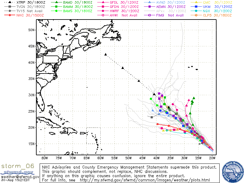
------------------------- Dora Hates You |
|
|
|
|
|
08/30/2015 04:24 PM
|
|
------------------------- Dora Hates You |
|
|
|
|
|
08/30/2015 05:42 PM
|
|
|
He may still send some long period swell our way if he gets close enough before going out to sea.
|
|
|
|
|
|
FORUMS
:
Surfing
:
Fred. Our next hope.
|
Topic Tools |
FuseTalk Basic Edition - © 1999-2024 FuseTalk Inc. All rights reserved.