
 |
2nd Light Forums |
 |
 |  |


|
Topic Title: Is it to early to start up the Hype train ? Topic Summary: The Low that came off Africa looks like it could make a run up the coast Created On: 07/25/2020 04:54 PM |
Linear : Threading : Single : Branch |
 |
- Kimo63 | - 07/25/2020 04:54 PM |
|
- Central Floridave | - 07/26/2020 04:29 AM |
|
- dingpatch | - 07/26/2020 04:54 AM |
|
- Central Floridave | - 07/26/2020 06:06 AM |
|
- jdbman | - 07/26/2020 06:24 AM |
|
- Plan B | - 07/26/2020 06:45 AM |
|
- Cole | - 07/26/2020 07:41 AM |
|
- sattylife | - 07/26/2020 07:10 PM |
|
- fishkller | - 07/26/2020 08:41 PM |
|
- all3 | - 07/26/2020 09:24 PM |
|
- jdbman | - 07/27/2020 07:23 AM |
|
- Plan B | - 07/27/2020 12:26 PM |
|
- harrietdubman | - 07/27/2020 12:44 PM |
|
- K07 | - 07/27/2020 08:17 PM |
|
- Plan B | - 07/28/2020 04:08 AM |
|
- dingpatch | - 07/28/2020 06:08 AM |
|
- dingpatch | - 07/28/2020 06:12 AM |
|
- tom | - 07/28/2020 06:15 AM |
|
- tom | - 07/28/2020 06:25 AM |
|
- garcia | - 07/28/2020 06:40 AM |
|
- mp2115 | - 07/28/2020 06:44 AM |
|
- seaspray | - 07/28/2020 06:49 AM |
|
- long_flaco1 | - 07/28/2020 07:47 AM |
|
- garcia | - 07/28/2020 08:06 AM |
|
- mp2115 | - 07/28/2020 08:25 AM |
|
- garcia | - 07/28/2020 08:38 AM |
|
- dingpatch | - 07/28/2020 08:42 AM |
|
- LaJune | - 07/28/2020 08:59 AM |
|
- Plan B | - 07/28/2020 09:09 AM |
|
- mp2115 | - 07/28/2020 09:10 AM |
|
- Kimo63 | - 07/26/2020 08:45 AM |
|
- dingpatch | - 07/26/2020 11:47 AM |
|
- Greensleeves | - 07/26/2020 12:05 PM |
|
- GreenLantern | - 07/26/2020 01:03 PM |
|
- RiddleMe | - 07/26/2020 01:19 PM |
|
- Cole | - 07/26/2020 02:55 PM |
|
- Central Floridave | - 07/27/2020 08:36 AM |
|
- long_flaco1 | - 07/27/2020 09:06 AM |
|
- Central Floridave | - 07/28/2020 04:01 AM |
|
- Kimo63 | - 07/28/2020 12:06 PM |
|
- GreenLantern | - 07/28/2020 01:11 PM |
|
- scostuart | - 07/28/2020 01:43 PM |
|
- Kimo63 | - 07/28/2020 05:10 PM |
|
- tom | - 07/28/2020 05:13 PM |
|
- Cole | - 07/28/2020 06:49 PM |
|
- Dahui321 | - 07/29/2020 03:06 AM |
|
- scostuart | - 07/29/2020 04:32 AM |
|
- StirfryMcflurry | - 07/29/2020 01:46 PM |
|
- mp2115 | - 07/29/2020 05:41 AM |
|
- SrfGtr | - 07/29/2020 05:52 AM |
|
- Central Floridave | - 07/29/2020 03:24 AM |
|
- Plan B | - 07/29/2020 04:17 AM |
|
- GreenLantern | - 07/29/2020 04:23 AM |
|
- johnnyboy | - 07/29/2020 05:55 AM |
|
- Skunkape | - 07/29/2020 07:07 AM |
|
- Cole | - 07/29/2020 07:18 AM |
|
- dingpatch | - 07/29/2020 08:24 AM |
|
- GreenLantern | - 07/29/2020 08:41 AM |
|
- Greensleeves | - 07/29/2020 10:56 AM |
|
- dingpatch | - 07/29/2020 11:33 AM |
|
- tom | - 07/29/2020 11:58 AM |
|
- dingpatch | - 07/29/2020 12:31 PM |
|
- scombrid | - 07/29/2020 12:56 PM |
|
- scombrid | - 07/29/2020 12:58 PM |
|
- StirfryMcflurry | - 07/29/2020 01:09 PM |
|
- dingpatch | - 07/29/2020 01:11 PM |
|
- Kimo63 | - 07/29/2020 01:31 PM |
|
- Cole | - 07/29/2020 04:04 PM |
|
- TATTOO74 | - 07/30/2020 05:43 AM |
|
- RiddleMe | - 07/30/2020 05:49 AM |
|
- dingpatch | - 07/30/2020 06:01 AM |
|
- RiddleMe | - 07/30/2020 06:18 AM |
|
- Plan B | - 07/30/2020 07:23 AM |
|
- e11even | - 07/30/2020 08:30 AM |
|
- GREG | - 07/30/2020 08:43 AM |
|
- Plan B | - 07/30/2020 08:52 AM |
|
- Plan B | - 07/30/2020 09:33 AM |
|
- Plan B | - 07/30/2020 02:24 PM |
|
- LongboardsnDonuts | - 07/30/2020 02:02 PM |
|
- Kimo63 | - 07/29/2020 06:31 PM |
|
- Cole | - 07/29/2020 07:16 PM |
|
- waterlizard25 | - 07/30/2020 05:32 AM |
|
- Plan B | - 07/30/2020 06:01 AM |
|
- seaspray | - 07/30/2020 06:13 AM |
|
- Cole | - 07/30/2020 08:48 AM |
|
- K07 | - 07/29/2020 07:24 PM |
|
- paddleout | - 07/29/2020 09:21 PM |
|
- mp2115 | - 07/30/2020 02:16 AM |
|
- Plan B | - 07/30/2020 04:47 AM |
|
- paddleout | - 07/30/2020 05:10 AM |
|
- long_flaco1 | - 07/30/2020 06:01 AM |
|
- Central Floridave | - 07/30/2020 11:01 AM |
|
- Central Floridave | - 07/30/2020 11:03 AM |
|
- Cole | - 07/30/2020 11:29 AM |
|
- dingpatch | - 07/30/2020 01:04 PM |
|
- Central Floridave | - 07/30/2020 01:59 PM |
|
- paddleout | - 07/30/2020 02:24 PM |
|
- paddleout | - 07/30/2020 02:25 PM |
|
- Plan B | - 07/30/2020 02:28 PM |
|
- paddleout | - 07/30/2020 02:29 PM |
|
- seaspray | - 07/30/2020 02:56 PM |
|
- K07 | - 07/30/2020 03:51 PM |
|
- StirfryMcflurry | - 07/31/2020 03:23 PM |
|
- Kimo63 | - 07/30/2020 05:56 PM |
|
- paddleout | - 07/30/2020 06:25 PM |
|
- Central Floridave | - 07/31/2020 03:57 AM |
|
- Central Floridave | - 07/31/2020 04:08 AM |
|
- Plan B | - 07/31/2020 04:32 AM |
|
- StirfryMcflurry | - 07/31/2020 05:33 AM |
|
- RiddleMe | - 07/31/2020 08:53 AM |
|
- StirfryMcflurry | - 07/31/2020 10:57 AM |
|
- seaspray | - 07/31/2020 11:11 AM |
|
- dkaye | - 07/31/2020 11:12 AM |
|
- RiddleMe | - 07/31/2020 11:25 AM |
|
- seaspray | - 07/31/2020 11:27 AM |
|
- RiddleMe | - 07/31/2020 11:32 AM |
|
- Plan B | - 07/31/2020 12:01 PM |
|
- paddleout | - 07/31/2020 03:49 PM |
|
- ww | - 07/31/2020 07:01 PM |
|
- equipeola | - 07/31/2020 12:08 PM |
|
- Central Floridave | - 07/31/2020 12:39 PM |
|
- Central Floridave | - 07/31/2020 12:40 PM |
|
- sw | - 07/31/2020 01:01 PM |
|
- slideaway | - 07/31/2020 01:05 PM |
|
- dkaye | - 07/31/2020 03:34 PM |
|
- johnnyboy | - 07/31/2020 02:36 PM |
|
- Cole | - 07/31/2020 02:51 PM |
|
- RocketSurf | - 07/31/2020 02:53 PM |
|
- goldfinger | - 07/31/2020 03:18 PM |
|
- RiddleMe | - 07/31/2020 03:45 PM |
|
- Cole | - 08/01/2020 07:17 AM |
|
- scombrid | - 08/01/2020 08:16 AM |
|
- scombrid | - 08/01/2020 08:57 AM |
|
- IamSAW | - 08/01/2020 08:59 AM |
|
- Central Floridave | - 07/31/2020 07:59 PM |
|
- ww | - 08/01/2020 01:09 AM |
|
- mp2115 | - 08/01/2020 02:08 AM |
|
- mp2115 | - 08/01/2020 02:21 AM |
|
- scombrid | - 08/01/2020 02:27 AM |
|
- Surfconch1 | - 08/01/2020 04:35 AM |
|
- dingpatch | - 08/01/2020 04:50 AM |
|
- ww | - 08/01/2020 05:08 AM |
|
- sharkfood | - 08/01/2020 04:58 AM |
|
- RiddleMe | - 08/01/2020 09:29 AM |
|
- dingpatch | - 08/01/2020 10:15 AM |
|
- jdbman | - 08/01/2020 05:51 AM |
|
- scombrid | - 08/01/2020 06:44 AM |
|
- scombrid | - 08/01/2020 06:49 AM |
|
- paddleout | - 08/01/2020 09:01 AM |
|
- scombrid | - 08/01/2020 09:20 AM |
|
- Central Floridave | - 08/01/2020 06:51 AM |
|
- Central Floridave | - 08/01/2020 09:24 AM |
|
- Central Floridave | - 08/01/2020 10:22 AM |
|
- dingpatch | - 08/01/2020 10:39 AM |
|
- Kimo63 | - 08/01/2020 12:17 PM |
|
- pumphouse | - 08/01/2020 01:29 PM |
|
- paddleout | - 08/01/2020 01:31 PM |
|
- scombrid | - 08/01/2020 01:43 PM |
|
- StirfryMcflurry | - 08/01/2020 02:12 PM |
|
- scostuart | - 08/01/2020 02:18 PM |
|
- Central Floridave | - 08/01/2020 04:15 PM |
|
- Plan B | - 08/01/2020 05:06 PM |
|
- johnnyboy | - 08/01/2020 08:42 PM |
|
- paddleout | - 08/01/2020 10:07 PM |
|
- ww | - 08/02/2020 01:47 AM |
|
- equipeola | - 08/02/2020 05:46 AM |
|
- dingpatch | - 08/02/2020 06:09 AM |
|
- scombrid | - 08/02/2020 07:21 AM |
|
- Cole | - 08/02/2020 10:36 AM |
|
- johnnyboy | - 08/02/2020 02:13 PM |
|
- Cole | - 08/02/2020 03:37 PM |
|
- Cole | - 08/02/2020 04:13 PM |
|
- paddleout | - 08/02/2020 04:32 PM |
|
- tom | - 08/02/2020 05:31 PM |
|
- scombrid | - 08/02/2020 10:14 PM |
|
- scombrid | - 08/02/2020 10:25 PM |
|
- GreenLantern | - 08/03/2020 02:51 AM |
|
- GreenLantern | - 08/03/2020 02:52 AM |
|
- dkaye | - 08/03/2020 04:20 AM |
|
- Plan B | - 08/03/2020 04:51 AM |
|
- Cole | - 08/03/2020 06:27 AM |
|
- RiddleMe | - 08/03/2020 08:55 AM |
|
- long_flaco1 | - 08/03/2020 09:22 AM |
|
- scombrid | - 08/03/2020 10:19 AM |
|
- IamSAW2 | - 08/03/2020 11:00 AM |
|
- seaspray | - 08/03/2020 11:04 AM |
|
- Cole | - 08/03/2020 11:44 AM |
|
- Cole | - 08/03/2020 11:44 AM |
|
- scombrid | - 08/03/2020 01:02 PM |
|
- scostuart | - 08/03/2020 01:27 PM |
|
- SurferMic | - 08/03/2020 01:49 PM |
|
- Cole | - 08/03/2020 04:17 PM |
|
- Ragga P | - 08/03/2020 04:55 PM |
|
- goldfinger | - 08/03/2020 05:07 PM |
|
- Central Floridave | - 08/03/2020 05:56 PM |
|
- Central Floridave | - 08/03/2020 06:49 PM |
|
- mp2115 | - 08/04/2020 02:56 AM |
|
- dkaye | - 08/04/2020 03:38 AM |
|
- johnnyboy | - 08/04/2020 06:48 AM |
|
- Plan B | - 08/04/2020 08:04 AM |
|
- Tiptime | - 08/05/2020 07:20 AM |
 Topic Tools Topic Tools
|

 07/25/2020 04:54 PM 07/25/2020 04:54 PM


|
|
|
Tropical tidbits , Surfline and the GFS all have the wayout prediction putting this in our swell window the first week of August . Currently it's still about 32 West longitude
Edited: 07/25/2020 at 04:56 PM by Kimo63 |
|
|
|
|
|
07/26/2020 04:29 AM
|
|
|
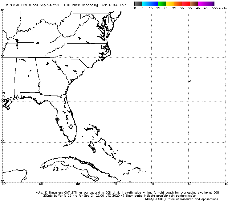
Tropical Weather Outlook
NWS National Hurricane Center Miami FL 800 AM EDT Sun Jul 26 2020 For the North Atlantic...Caribbean Sea and the Gulf of Mexico: The National Hurricane Center is issuing advisories on Tropical Storm Hanna, located inland near the border of Texas and Mexico. 1. A broad area of low pressure associated with a tropical wave is located about 1000 miles west-southwest of the Cabo Verde Islands. This system is producing a wide area of disorganized showers and thunderstorms as it moves westward around 20 mph across the tropical Atlantic. Environmental conditions are forecast to be conducive for development and a tropical depressions is likely to form within the next few days as the system nears the Lesser Antilles. Interests in the Lesser Antilles should monitor the progress of this system. * Formation chance through 48 hours...medium...60 percent. * Formation chance through 5 days...high...90 percent. |
|
|
|
|
|
07/26/2020 04:54 AM
|
|
------------------------- Dora Hates You |
|
|
|
|
|
07/26/2020 06:06 AM
|
|
|
fyi, virtual buoys showing long period tick next weekend. Hope it happens and that thing recurves out to sea.
|
|
|
|
|
|
07/26/2020 06:24 AM
|
|
|
"The intensity of #92L will possibly help determine its long term track. A stronger system will likely feel a forecasted trough in the 6-10 day range, while a weaker system could track into the Caribbean or through the Greater Antilles. The door is open for all possibilities..."
------------------------- So if you are a surfer I wish you the prosperity that allows you more time to pursue the salt water dream, and the true happiness that comes from warm water, clean waves and the companionship of your fellow surfers. If you are an internet troll just spewing bs then f off. |
|
|
|
|
|
07/26/2020 06:45 AM
|
|
|
|
|
|
|
|
|
07/26/2020 07:41 AM
|
|
|
My prediction: Two days of monster closed out walls in onshores, followed by three hours of chest high bowls with west winds before dark and flat the next day.
------------------------- I was right. |
|
|
|
|
|
07/26/2020 07:10 PM
|
|
|
|
|
|
|
|
|
07/26/2020 08:41 PM
|
|
|
My prediction: Two days of monster closed out walls in onshores, followed by three hours of chest high bowls with west winds before dark and flat the next day. Cole, you are being too optimistic. I have made a correction for you LOL Two days of monster closed out walls in onshores, followed by three hours of chest high bowls with west winds AFTER dark and flat the next day ------------------------- 
Zzzzzzz.. Zzzzzzz.. Braaaaaapp! Zzzzzzzzzzzzzz.... |
|
|
|
|
|
07/26/2020 09:24 PM
|
|
|
looks to me like its going to turn into a monster, hope it heads north sooner rather than later
------------------------- "I remember South Africa in the late 70's, sleeping on the beach at J-bay, smoking ganja with the blacks. On weekends we'd go to the pub in East London to drink beer and fight with the Afrikaners. They liked to fight, I liked to fight. It was a good time" |
|
|
|
|
|
07/27/2020 07:23 AM
|
|
|
"92L is dealing with some struggles today. It's ingesting quite a bit of Saharan dry air and is moving very quickly. The circulation is also very large which is helping to pull that dry air in. Large waves need a moist environment. Don't see this pulling together soon. We'll see."
------------------------- So if you are a surfer I wish you the prosperity that allows you more time to pursue the salt water dream, and the true happiness that comes from warm water, clean waves and the companionship of your fellow surfers. If you are an internet troll just spewing bs then f off. |
|
|
|
|
|
07/27/2020 12:26 PM
|
|

|
|
|
|
|
|
07/27/2020 12:44 PM
|
|

------------------------- sneedeker Edited: 07/27/2020 at 12:46 PM by harrietdubman |
|
|
|
|
|
07/27/2020 08:17 PM
|
|
|
It doesn't have to do much really.. it's a-symmetrical yes but on the northern half. The larger wind field is good for swell generation, so as long as it doesn't dive into the Caribbean it should usher in a nice SE swell for the weekend (Euro has trended a bit north today too aligning more with the GFS). With this scenario, falling apart as it approaches keeps our conditions good and doesn't threaten a costly landfall (swell will already be created). It's kind of a rare but good scenario. Normally when they approach like this we don't get swell before the bad winds, and we're praying for a recurve to avoid landfall and to get the good conditions. The next 48 hours are key.
|
|
|
|
|
|
07/28/2020 04:08 AM
|
|
|
|
|
|
|
|
|
07/28/2020 06:08 AM
|
|
|
Tracking more West.
The spaghetti models now show it coming into FLA. 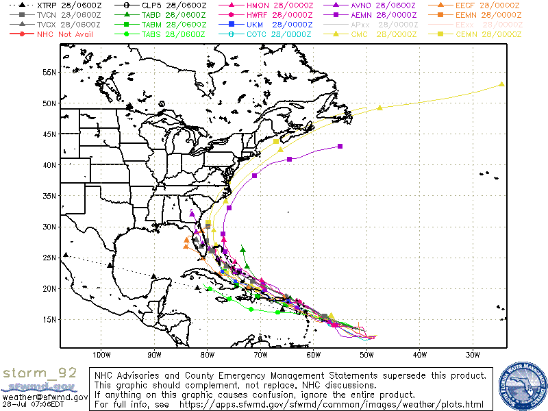
------------------------- Dora Hates You |
|
|
|
|
|
07/28/2020 06:12 AM
|
|
|
Yep, as previously discussed here, I've lived in Brevard since 1954 and I AM OVER IT! If it's going to be here as anything close to even a CAT 1, I'm Out Of Here!
But, then again, on last night's weather on WFTV (Ch 9) Tom Terry was showing longer term projections that show this as a big blob of rain passing to the south of Cuba but, with plenty of Wet for us. "Most" models do not show it becoming a hurricane. We shall see by Thursday night. ------------------------- Dora Hates You Edited: 07/28/2020 at 06:16 AM by dingpatch |
|
|
|
|
|
07/28/2020 06:15 AM
|
|
|
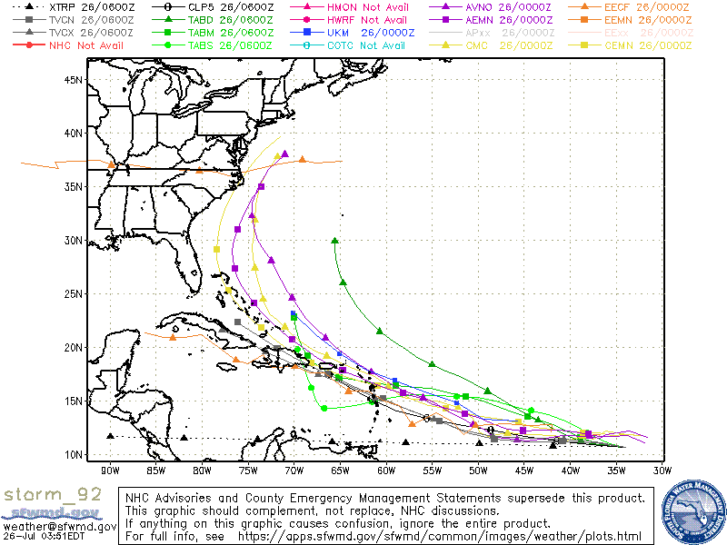
Funny, from ding's graphic above, "NHC Advisories and County Emergency Management statements supersede..." bla bla bla. Notice the only model missing? NHC.
------------------------- add a signature since I'm here in profile anyway |
|
|
|
|
|
07/28/2020 06:25 AM
|
|
|
FWIW: Looked at the Navy's site, FNMOC, just now. GFS show a fizzle on Sat. WW3 shows a fairly strong storm <100 miles off 2ndlight on Sun. Be prepared scouts.
------------------------- add a signature since I'm here in profile anyway |
|
|
|
|
|
07/28/2020 06:40 AM
|
|
|
I don't know what sites to believe anymore. I used to use weatherunderground, and especially follow the Euro model but, after McMasters sold it, they are garbage. They don't even have a forecast for 92L, just a satellite image. I also use FNMOC but, they have changed it and the wave height forecast under the Meteorology Products link is completely different than the models shown under Tropical Applications, which, for the past few days, hasn't even had a forecasted path. I have gone directly to the Euro models but they have two different forecasted track overlays and they are both different too and they are too small to read which model is being used for which track. I sure miss McMaster's old weatherunderground blog and forecast maps.
|
|
|
|
|
|
07/28/2020 06:44 AM
|
|
|
Its July and nothing to be concerned about until NHC gives a briefing on strength, location and destination. Check out Tropicaltidbits for entertainment first yet useful info on models
|
|
|
|
|
|
07/28/2020 06:49 AM
|
|
|
Stay positive ya'll
Tropical storm far out into the sea, head high clean waves, during the weekend. Cold beer in your fridge waiting for you |
|
|
|
|
|
07/28/2020 07:47 AM
|
|
|
Stay positive ya'll Tropical storm far out into the sea, head high clean waves, during the weekend. Cold beer in your fridge waiting for you *DOUBLE SHAKA'S* ------------------------- SK8 AND DESTROY |
|
|
|
|
|
07/28/2020 08:06 AM
|
|
|
mp2115 - Not worried, just interested
|
|
|
|
|
|
07/28/2020 08:25 AM
|
|
|
NHC just posted
|
|
|
|
|
|
07/28/2020 08:38 AM
|
|
|
Just saw it. Thanks.
|
|
|
|
|
|
07/28/2020 08:42 AM
|
|
|
Fuck! Do you think I have enough time to get COVID and die before it gets here?
------------------------- Dora Hates You |
|
|
|
|
|
07/28/2020 08:59 AM
|
|
|
It's not going to hit Florida. If it stays as a weak TS or depression it will go south of the keys. If it gets to Hurricane status it will recurve and stay off shore. NHC is hedging their bets and forecasting something in the middle of that which I think is highly unlikely and so does the NHC.
------------------------- Heavy is sign of reliability |
|
|
|
|
|
07/28/2020 09:09 AM
|
|
 need that fetch to stay on the NE side, and I'm surfing all weekend.
 Edited: 07/28/2020 at 09:10 AM by Plan B |
|
|
|
|
|
07/28/2020 09:10 AM
|
|
|
|
|
|
|
|
|
07/26/2020 08:45 AM
|
|
|
The progressive runs have it farther out now . The winds look to be offshore Saturday and Sunday . Would be nice to enjoy clean waves with a little meat on them for a change .
|
|
|
|
|
|
07/26/2020 11:47 AM
|
|
|
Cole, spoken like a true Floridian!!
------------------------- Dora Hates You |
|
|
|
|
|
07/26/2020 12:05 PM
|
|
|
Today was sick.
|
|
|
|
|
|
07/26/2020 01:03 PM
|
|
|
yup right time tide and sandbar for this morning
fun waves and favorable winds all week in prep for our hurricane waves |
|
|
|
|
|
07/26/2020 01:19 PM
|
|
|
Today was sick. Glad someone got some. It wasn't close to workable at my spot. |
|
|
|
|
|
07/26/2020 02:55 PM
|
|
|
Today was sick. We wasted our time looking around down south when should have stayed up here. ------------------------- I was right. |
|
|
|
|
|
07/27/2020 08:36 AM
|
|
|
Long range tracking looks pretty good for recurve and staying WAY out to sea. Obviously looking at virtual buoys it shows a significant uptick for the weekend. Hope it happens!
|
|
|
|
|
|
07/27/2020 09:06 AM
|
|
|
KONA, KONA, KONA!!!!
------------------------- SK8 AND DESTROY |
|
|
|
|
|
07/28/2020 04:01 AM
|
|
|
Models changed up some overnight. Looks like tracking further East and moving closer to the Bahamas. Yesterday they showed it recurving North once above Puerto Rico. Something to watch!
Tropical Weather Outlook NWS National Hurricane Center Miami FL 200 AM EDT Tue Jul 28 2020 For the North Atlantic...Caribbean Sea and the Gulf of Mexico: 1. Shower activity associated with a low pressure area located about 750 miles east of the Windward Islands is gradually increasing in organization. However, recent satellite-derived wind data indicate that the circulation remains broad and elongated, and the low does not yet have a well-defined center of circulation. Environmental conditions are expected to become somewhat more conducive for development, and a tropical depression or tropical storm is likely to form during the next couple of days while the system moves west-northwestward at 15 to 20 mph and approaches the Leeward Islands. Regardless of development, locally heavy rains and gusty winds are likely across portions of the Leeward Islands on Wednesday and will spread westward to the Virgin Islands and Puerto Rico Wednesday night and Thursday. Interests on these islands should continue to monitor the progress of this system, and tropical storm watches or warnings could be required for portions of the area later today. * Formation chance through 48 hours...high...80 percent. * Formation chance through 5 days...high...90 percent. |
|
|
|
|
|
07/28/2020 12:06 PM
|
|
|
Checked the Buoys this afternoon , Mid Atlantic is showing 10 ft swell and 12 ft wind waves heading this way . Hope the wind stays light offshore this weekend .
|
|
|
|
|
|
07/28/2020 01:11 PM
|
|
|
no hype train
going to the gulf just saying though we should get some swell just not great winds |
|
|
|
|
|
07/28/2020 01:43 PM
|
|
|
------------------------- Waiting for waves is ok......most people spend their lives waiting for nothing. |
|
|
|
|
|
07/28/2020 05:10 PM
|
|
|
Buoy 41040 . All the good buoys have gone dark this evening , only red diamonds showing as offline .Not sure what the failure is .
|
|
|
|
|
|
07/28/2020 05:13 PM
|
|
|
^new board curse, early symptoms
------------------------- add a signature since I'm here in profile anyway |
|
|
|
|
|
07/28/2020 06:49 PM
|
|
|
Buoy 41040 . All the good buoys have gone dark this evening , only red diamonds showing as offline .Not sure what the failure is . I noticed that too, must be a server deal. ------------------------- I was right. |
|
|
|
|
|
07/29/2020 03:06 AM
|
|
|
Name the missing variable
1) bad winds
2) no swell
3) wrong tide
4) too long of period
5)dog ate my leash
Ahhhh surfing (or not) in Florida!!!!!
|
|
|
|
|
|
07/29/2020 04:32 AM
|
|
|
------------------------- Waiting for waves is ok......most people spend their lives waiting for nothing. |
|
|
|
|
|
07/29/2020 01:46 PM
|
|
|
|
|
|
|
|
|
07/29/2020 05:41 AM
|
|
|
|
|
|
|
|
|
07/29/2020 05:52 AM
|
|
|
U jag offs jinxed it w this hype asshattery!!!!
|
|
|
|
|
|
07/29/2020 03:24 AM
|
|
|
Potential Tropical Cyclone Nine Discussion Number 4
NWS National Hurricane Center Miami FL AL092020 500 AM AST Wed Jul 29 2020 Satellite and surface data indicate that the system remains a trough of low pressure, elongated from SSW to NNE, with almost all of the strong winds far north of the center position. The most significant curvature in the low-level wind field and on radar are near Dominica now, which has good continuity from the previous advisory, so this feature will continue to be used as the center. A combination of unflagged SFMR winds from an Air Force plane and earlier scatterometer winds support 40 kt as the initial wind speed. The initial motion estimate is about the same as before or 295/20 kt. The ridge to the north of the disturbance is forecast to remain strong for the next 36 h, which keeps the system moving speedily in a general west-northwestward direction just south of the Leeward Islands today, and near or over the Greater Antilles on Thursday. The ridge is forecast to weaken after that time, which should cause the cyclone to slow down, and potentially gain more latitude over the southwestern Atlantic. The model guidance is generally showing a narrow ridge persisting for a bit longer, however, causing a small south and west shift in the new NHC forecast at long range. However, it should be emphasized that this forecast track is highly uncertain until a true center forms. Satellite images indicate that a large burst of convection is occuring near the poorly defined center, which will likely lead to the system becoming a tropical storm later today. Further intensification is possible before landfall in the Dominican Republic on Thursday, assuming the structure continues to improve, and the wind speed forecast is adjusted slightly higher in the near term. The cyclone will probably take some time to recover after moving over the very high mountains of Hispaniola, and some of the guidance after that time shows an increase in southwesterly shear over the Straits of Florida that could limit the potential of the cyclone. Simply put, there are a lot of hurdles in the system's way, so it is best to stay on the conservative side at the moment and continue to stress the large uncertainty after it leaves the Caribbean. Little change was made to the forecast intensity, although the guidance has come down at longer range for many of the models. Interests in Hispaniola, the Bahamas, Cuba, and Florida should continue to monitor forecasts as changes to both the track and intensity are likely. Key Messages: 1. Potential Tropical Cyclone Nine will produce heavy rains and potentially life-threatening flash flooding and mudslides across the northern Leeward Islands, the Virgin Islands, Puerto Rico, and the Dominican Republic. 2. Tropical storm conditions are likely across portions of the Leeward Islands, the Virgin Islands and Puerto Rico today and spreading westward to portions of the Dominican Republic and Haiti on Thursday. Tropical Storm Warnings are in effect for these areas. Do not focus on the details of the track forecast, as rainfall and wind hazards will extend far from the center of the system. 3. The details of the long-range track and intensity forecasts are more uncertain than usual since the system does not have a well-defined center and it could move over portions of the Greater Antilles later this week. However, this system could bring some rainfall and wind impacts to portions of Cuba, the Bahamas, and Florida by the end of the week. Interests there should monitor its progress and updates to the forecast over the next few days. FORECAST POSITIONS AND MAX WINDS INIT 29/0900Z 15.3N 61.3W 40 KT 45 MPH...POTENTIAL TROP CYCLONE 12H 29/1800Z 16.3N 64.1W 45 KT 50 MPH...TROPICAL STORM 24H 30/0600Z 17.8N 67.6W 50 KT 60 MPH 36H 30/1800Z 19.3N 71.0W 40 KT 45 MPH...INLAND 48H 31/0600Z 20.6N 74.0W 40 KT 45 MPH...OVER WATER 60H 31/1800Z 22.1N 76.7W 45 KT 50 MPH 72H 01/0600Z 23.3N 78.7W 50 KT 60 MPH 96H 02/0600Z 25.5N 81.5W 55 KT 65 MPH 120H 03/0600Z 28.5N 83.0W 45 KT 50 MPH |
|
|
|
|
|
07/29/2020 04:17 AM
|
|
|
moving too fast
|
|
|
|
|
|
07/29/2020 04:23 AM
|
|
|
moving too fast going to the gulf |
|
|
|
|
|
07/29/2020 05:55 AM
|
|
|
New thread: is it too late to hype this?
------------------------- "One of the reasons why propaganda tries to get you to hate government is because it's the one existing institution in which people can participate to some extent and constrain tyrannical unaccountable power." Noam Chomsky. |
|
|
|
|
|
07/29/2020 07:07 AM
|
|
|
Amazing how adept these storms are at skirting our massive swell window and running over our tiny finger of land
|
|
|
|
|
|
07/29/2020 07:18 AM
|
|
|
Amazing how adept these storms are at skirting our massive swell window and running over our tiny finger of land ...after grinding their way up the Caribbean. "Why should I stay over the boring ocean when I can come and visit all of these people!" ------------------------- I was right. |
|
|
|
|
|
07/29/2020 08:24 AM
|
|
|
The NHC 11:00 puts it into the Gulf!! The winds are at 45 MPH so it will probably be named very shortly.
------------------------- Dora Hates You |
|
|
|
|
|
07/29/2020 08:41 AM
|
|
|
The NHC 11:00 puts it into the Gulf!! exactly what i been saying |
|
|
|
|
|
07/29/2020 10:56 AM
|
|
|
"Name the missing variable 1) bad winds 2) no swell 3) wrong tide 4) too long of period 5)dog ate my leash Ahhhh surfing (or not) in Florida!!!!! "
6) sandbars bite 7) Nighttime 8) storm goes in gulf |
|
|
|
|
|
07/29/2020 11:33 AM
|
|
|
At the "2:00" more of the models have shifted to the west. Only a few are still "on" FLA.
------------------------- Dora Hates You |
|
|
|
|
|
07/29/2020 11:58 AM
|
|
|
9) wrong board, shortboard and it's a foot and a half 10) forgot water and sunscreen 11) baggies split the butt seam so you're surfing in your shorts, commando, and with a steel zipper 12) laser sharks...
------------------------- add a signature since I'm here in profile anyway |
|
|
|
|
|
07/29/2020 12:31 PM
|
|
|
Ummmmm, , , , at 3:00 a lot of the models are now back to the East just off the coast.
------------------------- Dora Hates You |
|
|
|
|
|
07/29/2020 12:56 PM
|
|
|
A lot hinges on where the eventual closed low forms. Just like with Dorian. Right now the circulation is very broad and diffuse.
------------------------- ... |
|
|
|
|
|
07/29/2020 12:58 PM
|
|
|
General troughiness in our vicinity will draw it more north if the circulation consolidates in the north half of the current low.
------------------------- ... |
|
|
|
|
|
07/29/2020 01:09 PM
|
|
|
do we load up da bus to da light, or no?
|
|
|
|
|
|
07/29/2020 01:11 PM
|
|
|
The mountains of PR, Hispaniola and Cuba will keep it from forming up too much.
------------------------- Dora Hates You |
|
|
|
|
|
07/29/2020 01:31 PM
|
|
|
The St Maarten Buoy has been 8 feet at 10 sec Se/E swell , 10 feet of wind driven wave on top of that . All heading our way . We should have something to ride , wind speed and direction is the bigger question for your local break
|
|
|
|
|
|
07/29/2020 04:04 PM
|
|
|
wind speed and direction is the bigger question for your local break
You could have condensed this by just saying, "Florida." ------------------------- I was right. |
|
|
|
|
|
07/30/2020 05:43 AM
|
|
|
wind speed and direction is the bigger question for your local break You could have condensed this by just saying, "Florida." "You shoulda been here an hour ago" |
|
|
|
|
|
07/30/2020 05:49 AM
|
|
|
"You shoulda been here an hour ago" LOL Exactly. Thats what is happening with this. Coast hugger that froths us up followed by a 1 hour window where it is stiff offshore and cleans up with enough size to fight the wind before getting blown out. Then flat the next morning. |
|
|
|
|
|
07/30/2020 06:01 AM
|
|
|
Yes, "Should have been here an hour ago" is our very own Florida phrase.
But, we must also remember that "It is always better where you are not"! ------------------------- Dora Hates You |
|
|
|
|
|
07/30/2020 06:18 AM
|
|
|
But, we must also remember that "It is always better where you are not"! That and Tip always makes it look better than it actually was. He has an eye for catching the best waves with the camera. |
|
|
|
|
|
07/30/2020 07:23 AM
|
|
|
Check buoy 46.... yeewwwwww
|
|
|
|
|
|
07/30/2020 08:30 AM
|
|
|
------------------------- - |
|
|
|
|
|
07/30/2020 08:43 AM
|
|
|
Anybody heading up to the Outer Banks? I will be there Sunday and possibly Monday. Pray 4 Waves!
------------------------- http://www.crsurf.com ~ CR Surf Travel Company http://www.vacationsbygreg.com Instagram - @crsurf |
|
|
|
|
|
07/30/2020 08:52 AM
|
|
|
|
|
|
|
|
|
07/30/2020 09:33 AM
|
|
|
Just need it to jog a little north and the swell machine switches to full speed ahead....:
Edited: 07/30/2020 at 09:34 AM by Plan B |
|
|
|
|
|
07/30/2020 02:24 PM
|
|

|
|
|
|
|
|
07/30/2020 02:02 PM
|
|
|
------------------------- "Man is the only creature who refuses to be what he is" a.camus |
|
|
|
|
|
07/29/2020 06:31 PM
|
|
|
Cole , I get it. The days of light offshores in the morning and heavy offshores in the afternoon , stopped when I left Haleiwa . I took a lot for granted in those days. Now I just hope it follows the GFS track , gives us better winds and something to ride without tearing the place up .
|
|
|
|
|
|
07/29/2020 07:16 PM
|
|
|
Cole , I get it. The days of light offshores in the morning and heavy offshores in the afternoon , stopped when I left Haleiwa . I took a lot for granted in those days. Now I just hope it follows the GFS track , gives us better winds and something to ride without tearing the place up . Heard that. Mother Nature needs to give us a break for once. Make that a double break; good surf and no coastal thrashing. ------------------------- I was right. |
|
|
|
|
|
07/30/2020 05:32 AM
|
|
|
|
|
|
|
|
|
07/30/2020 06:01 AM
|
|
|
|
|
|
|
|
|
07/30/2020 06:13 AM
|
|
|
That storm name was the jinx. Its usually the exotic-sounding names that brings a good swell with no damage
|
|
|
|
|
|
07/30/2020 08:48 AM
|
|
|
Clean pumping groundswell instead of Hurricanes knocking on the front door? Exactly. ------------------------- I was right. |
|
|
|
|
|
07/29/2020 07:24 PM
|
|
|
Wow this is such a weird storm really confusing the models haha it's changed so much today! I've never heard this much discussion about a "potential tropical cyclone" or whatever they're STILL calling it, is this a new classification? Not even worthy of depression status? HAha I mean it's a warm core low with sustained winds >40mph? Anyway the broad wind field is good and swell is already headed our way. Just gotta hope it falls apart or gives us a track where you can be in the swell and on the "right side of the storm".. we shall see but the swell charts are almost in line with major hurricane level! That Bahama shadow is looking to come pretty far north on this one though.
|
|
|
|
|
|
07/29/2020 09:21 PM
|
|
|
Check out windy.com for Sat & Sun storm is off the east coast with 20-30mph onshores sat, then 10-15mph offshores all day sunday. hmmm |
|
|
|
|
|
07/30/2020 02:16 AM
|
|
|
|
|
|
|
|
|
07/30/2020 04:47 AM
|
|
|
Last nights GFS was too good to be true.... now.... Either way, swell headed NW. Lets hope it takes a track where the wind doesnt hose us too bad: buoys
Buoy 46 = YEEWWWWW
|
|
|
|
|
|
07/30/2020 05:10 AM
|
|
|
the windy.com forecast has changed since lasr night.
now it looks like crap. |
|
|
|
|
|
07/30/2020 06:01 AM
|
|
|
Sending "Positive Vibrations" out to the universe for a fun swell with offshores (In Brevard County) at SOME POINT this weekend! (Glass half full outlook for LIFE YO!)
------------------------- SK8 AND DESTROY |
|
|
|
|
|
07/30/2020 11:01 AM
|
|
|
DISCUSSION AND OUTLOOK
---------------------- At 200 PM AST (1800 UTC), the center of Tropical Storm Isaias was located near latitude 18.9 North, longitude 69.8 West. Isaias is moving toward the northwest near 20 mph (31 km/h), and a west- northwestward to northwestward motion with some decrease in forward speed is expected over the next couple of days. On the forecast track, the center of Isaias will continue to move over Hispaniola through this evening, and be near the Southeastern Bahamas by late tonight or early Friday. Isaias is forecast to be near the Central Bahamas Friday night and move near or over the Northwest Bahamas or South Florida on Saturday. Maximum sustained winds are near 60 mph (95 km/h) with higher gusts. Some slight weakening is possible as Isaias continues to move over Hispaniola today. Re-strengthening is forecast on Friday and Friday night. Tropical-storm-force winds extend outward up to 310 miles (500 km) primarily to the north of the center. A weather station at Punta Cana near the eastern tip of the Dominican Republic reported sustained winds of 39 mph (63 km/h) with a gust to 52 mph (83 km/h) within the past couple of hours. The estimated minimum central pressure is 1003 mb (29.62 inches). |
|
|
|
|
|
07/30/2020 11:03 AM
|
|
|
Cape Verde possible storm from 2pm NHC update as well
Tropical Weather Outlook NWS National Hurricane Center Miami FL 200 PM EDT Thu Jul 30 2020 For the North Atlantic...Caribbean Sea and the Gulf of Mexico: The National Hurricane Center is issuing advisories on Tropical Storm Isaias, located over the northeastern Caribbean Sea. 1. Showers and thunderstorms associated with a small area of low pressure, located a few hundred miles south-southeast of the Cabo Verde Islands have increased and become better organized during the day. Environmental conditions appear conducive for further development, and this system could become a tropical depression during the next day or so while it drifts generally north-northwestward. After that time, environmental conditions are forecast to become less favorable for development. * Formation chance through 48 hours...medium...50 percent. * Formation chance through 5 days...medium...50 percent. |
|
|
|
|
|
07/30/2020 11:29 AM
|
|
|
The new update has it making a visit to Brevard.
Fl, not NC. ------------------------- I was right. |
|
|
|
|
|
07/30/2020 01:04 PM
|
|
|
The preponderance of the models have it out East and into the Bahamas.
The 20 hundred hours runs should look much better for us (hope). ------------------------- Dora Hates You Edited: 07/30/2020 at 01:05 PM by dingpatch |
|
|
|
|
|
07/30/2020 01:59 PM
|
|
|
Tropical Storm Isaias Discussion Number 10
NWS National Hurricane Center Miami FL AL092020 500 PM EDT Thu Jul 30 2020 Surface observations in the Dominican Republic indicate that the poorly defined center of Isaias moved over the southeastern portion of Hispaniola around 1600 UTC. There is currently a significant concentration of convection near the mid-level center that is located along the northern coast of the island, and recent surface observations suggest that a new center may be forming near the area of mid-level rotation seen in satellite imagery. The advisory position has been placed between the previous estimated center location and the mid-level center until it becomes more clear that reformation has occurred. Earlier ASCAT data that arrived shortly after the previous advisory and reconnaissance aircraft data from this morning supported an intensity of 45-50 kt, and since there has no significant degradation the overall organization since that time, the initial intensity remains 50 kt. The central pressure of 999 mb is based on a surface observation of 1001 mb and 25 kt of wind at Puerto Plata in the Dominican Republic. The initial motion estimate is a somewhat uncertain 310/17 kt. The track forecast reasoning has not changed since the previous advisory. The tropical storm should continue on a general northwest heading during the next 24 to 36 hours along the southern side of a subtropical ridge. After that time, a trough moving into the east-central United States should cause Isaias to turn north-northwestward and northward as the western portion of the ridge erodes. By early next week, Isaias is expected to turn northeastward and accelerate ahead of the aforementioned trough. The 1200 UTC dynamical model guidance has shifted eastward and now that Isaias is expected to become a stronger and deeper cyclone, that also favors a more eastward track. The updated official forecast is a blend of the various consensus aids. Since the new center is still in its formative stage some additional shifts in the track may occur. In addition, strong winds and heavy rainfall will extend far from the center. Visible imagery has shown significant banding near the mid-level circulation. Assuming that the center reforms near that feature and moves away from Hispaniola tonight, strengthening is expected during the next 24-36 hours and Isaias is now forecast to become a hurricane. After that time, there are mixed signals regarding the amount of southwesterly vertical wind shear and the models generally do not show much additional strengthening. Therefore, the NHC intensity forecast shows a leveling off in intensity after 48 h. It still needs to be stressed that that there is a higher than usual amount of uncertainty in the intensity forecast. Key Messages: 1. Isaias will produce heavy rains and potentially life-threatening flash flooding and mudslides across Puerto Rico, the Dominican Republic, northern Haiti, Turks and Caicos and the Bahamas. 2. Hurricane conditions and dangerous storm surge are expected in portions of the central and northwest Bahamas late Friday and Saturday. Preparations to protect life and property should be rushed to completion. Tropical storm conditions will continue to spread across portions of the Dominican Republic, Haiti, the Turks and Caicos and the southeast Bahamas tonight through Friday, and Tropical Storm Warnings are in effect for these areas. 3. Tropical storm conditions are possible along portions of the Florida east coast beginning Saturday, and a Tropical Storm Watch has been issued. While storm surge watches are not currently needed for this area, they may be required tonight or early tomorrow if the forecast track shifts closer to the coast. Heavy rains associated with Isaias may begin to affect eastern Florida this weekend, potentially resulting in isolated flash and urban flooding. 4. There is a risk of impacts from winds, heavy rainfall, and storm surge this weekend along the Florida east coast and spreading northward along the remainder of the U.S. east coast through early next week. The details of the track and intensity forecast remain uncertain and it is too soon to determine the magnitude and location of these potential impacts, but interests along the entire U.S. east coast should monitor the progress of Isaias and updates to the forecast. FORECAST POSITIONS AND MAX WINDS INIT 30/2100Z 19.5N 70.6W 50 KT 60 MPH...INLAND 12H 31/0600Z 20.8N 72.7W 55 KT 65 MPH...OVER WATER 24H 31/1800Z 22.7N 75.1W 60 KT 70 MPH 36H 01/0600Z 24.5N 77.1W 65 KT 75 MPH 48H 01/1800Z 26.1N 78.5W 65 KT 75 MPH 60H 02/0600Z 27.7N 79.5W 65 KT 75 MPH 72H 02/1800Z 29.2N 79.7W 65 KT 75 MPH 96H 03/1800Z 33.3N 78.0W 65 KT 75 MPH 120H 04/1800Z 40.0N 71.0W 60 KT 70 MPH |
|
|
|
|
|
07/30/2020 02:24 PM
|
|
|
Well, now it's a hurricane- and right on our doorstep.
RECURVE BABY!
Edited: 07/30/2020 at 02:24 PM by paddleout |
|
|
|
|
|
07/30/2020 02:25 PM
|
|
|
..and in the meantime, the real monster just made it's appearance off the coast of Africa |
|
|
|
|
|
07/30/2020 02:28 PM
|
|

|
|
|
|
|
|
07/30/2020 02:29 PM
|
|
|
On the hopeful side, windy.com is now showing offshores again on Monday. Strong ones though. But if it keeps moving out to sea... |
|
|
|
|
|
07/30/2020 02:56 PM
|
|
|
Looks like the Home Depots, Lowe's, Publix's really need the business
|
|
|
|
|
|
07/30/2020 03:51 PM
|
|
|
And just like that looks like we're getting a 'cane! Pray for that offshore recurve!
|
|
|
|
|
|
07/31/2020 03:23 PM
|
|
|
Bad timing ..........for the Bob & Doug Dragon re-entry........ Sunday afternoon?
|
|
|
|
|
|
07/30/2020 05:56 PM
|
|
|
The 46 Buoy lit up earlier , now the South Bermuda . Shouldn't be long before the NE Bahamas starts to show then wait about 10 -12 hours for our beaches to see it . Update : the 47 just got a ping of 5 feet at 15sec , the worms are on the move
Edited: 07/30/2020 at 06:04 PM by Kimo63 |
|
|
|
|
|
07/30/2020 06:25 PM
|
|
|
Well, at the moment, there's a possibility we can get hit with a Cat1 within a few days..
check out Levi's latest vid- especially at 6:00 and 8:45 Also, check out Windy.com Sunday at 6pm- just a cool looking effect.. http://www.windy.com/?2020-08-...57,-80.354,8,m:erJadUZ Edited: 07/30/2020 at 06:33 PM by paddleout |
|
|
|
|
|
07/31/2020 03:57 AM
|
|
|
Friday 5am update forecast
FORECAST POSITIONS AND MAX WINDS INIT 31/0900Z 20.9N 73.3W 70 KT 80 MPH 12H 31/1800Z 22.3N 75.0W 80 KT 90 MPH 24H 01/0600Z 24.0N 77.0W 85 KT 100 MPH 36H 01/1800Z 25.7N 78.5W 80 KT 90 MPH 48H 02/0600Z 27.3N 79.4W 75 KT 85 MPH 60H 02/1800Z 28.8N 79.6W 75 KT 85 MPH 72H 03/0600Z 30.6N 79.3W 70 KT 80 MPH 96H 04/0600Z 36.5N 75.5W 65 KT 75 MPH 120H 05/0600Z 42.5N 69.0W 55 KT 65 MPH |
|
|
|
|
|
07/31/2020 04:08 AM
|
|
|
The hurricane has been moving between west-northwest and northwest
during the last several hours, estimated at 305/15 now. Isaias should gradually turn to the north-northwest and north over the weekend as it moves around the western periphery of a weakening western Atlantic subtropical ridge. Guidance is in fairly good agreement over the first couple of days of the forecast, so little change is made at that time, other than a small westward adjustment near the Bahamas. After that time, there is a considerable spread, growing to over 700 miles, in the reliable models on how quickly Isaias moves northeastward near the east coast of the United States. The large spread appears to be related to both how strong the cyclone is by early next week and how much mid-level ridging remains near the Carolinas. There are no obvious reasons to choose either the fast GFS or slow ECMWF right now, so the official forecast will remain close to the previous one and the model consensus. It should be noted that given this large spread, the extended forecast could be subject to large speed/timing changes if either of those solutions become more likely. Strengthening is expected during the next day or so while the hurricane remains over the very warm waters near the Bahamas with reasonably low vertical shear. The forecast for the first 24 hours has been raised from earlier, at the top of the guidance spread. Increasingly southwesterly flow aloft should cause an increase in shear over the weekend, which is forecast by most of the guidance to lead to a gradual decrease in intensity. The details are not very clear at all, especially considering the track uncertainty, but there is a notable chance of a hurricane moving close to the U.S. East coast, so the forecast continues to show that scenario. |
|
|
|
|
|
07/31/2020 04:32 AM
|
|
|
|
|
|
|
|
|
07/31/2020 05:33 AM
|
|
|
|
|
|
|
|
|
07/31/2020 08:53 AM
|
|
|
There is some 15s period showing up on the 120 now. Can only see it on spectral density currently
|
|
|
|
|
|
07/31/2020 10:57 AM
|
|
|
Bombogenesis?
|
|
|
|
|
|
07/31/2020 11:11 AM
|
|
|
Had to get wet one last time this afternoon, and said my goodbyes to the sandbars that have been working really well for me this past month.
It's funny how we go from wanting some swell, to a state of emergency. I feel like I have a target on my back with these hurricanes with destruction potential Edited: 07/31/2020 at 12:24 PM by seaspray |
|
|
|
|
|
07/31/2020 11:12 AM
|
|
|
17 second wave just hit the one mile bababooey
------------------------- https://www.instagram.com/dj_kaye_/ |
|
|
|
|
|
07/31/2020 11:25 AM
|
|

Shifted west on an earlier run. Now another west shift on the models. Prepare to get strafed. |
|
|
|
|
|
07/31/2020 11:27 AM
|
|
|
You look at that track, and you wonder about the many storms like that over a span of thousands of years were responsible for shaping the eastern coastline
|
|
|
|
|
|
07/31/2020 11:32 AM
|
|
|
Ooops
Edited: 07/31/2020 at 11:32 AM by RiddleMe |
|
|
|
|
|
07/31/2020 12:01 PM
|
|
|
THIS TRAIN SUCKS!
|
|
|
|
|
|
07/31/2020 03:49 PM
|
|
|
You look at that track, and you wonder about the many storms like that over a span of thousands of years were responsible for shaping the eastern coastline Seaspray- I used to wonder that myself. But it turns out that it always had more or less that shape, waaay back millions of years before the tectonic plates moved to where there are now. pangea map with current borders: http://brilliantmaps.com/pangaea/ |
|
|
|
|
|
07/31/2020 07:01 PM
|
|
|
Gout attack. The gods must be sending a message.
|
|
|
|
|
|
07/31/2020 12:08 PM
|
|
|
------------------------- ola ~ |
|
|
|
|
|
07/31/2020 12:39 PM
|
|
|
FYI, 20 mike buoy shows first long period tick now.
|
|
|
|
|
|
07/31/2020 12:40 PM
|
|
|
Mile.
|
|
|
|
|
|
07/31/2020 01:01 PM
|
|
|
Size increase starting to show on the 120 miler
|
|
|
|
|
|
07/31/2020 01:05 PM
|
|
|
3-4 ft here in Cocoa Beach... long lines starting to come in at 4 PM
------------------------- "It's always better than it looks from the crossover." |
|
|
|
|
|
07/31/2020 03:34 PM
|
|
|
thank god we've had waves in this complete shit show of a year
come on fall!!
------------------------- https://www.instagram.com/dj_kaye_/ |
|
|
|
|
|
07/31/2020 02:36 PM
|
|
|
Weiland has it flat in south Florida on Sunday.
------------------------- "One of the reasons why propaganda tries to get you to hate government is because it's the one existing institution in which people can participate to some extent and constrain tyrannical unaccountable power." Noam Chomsky. |
|
|
|
|
|
07/31/2020 02:51 PM
|
|
|
Long closed out lines in Cocoa Beach. Not surprised at all. lol
------------------------- I was right. |
|
|
|
|
|
07/31/2020 02:53 PM
|
|
|
What about this little <40% probability yellow X?
Flowing right into the slot......hype train continues. NOAA link |
|
|
|
|
|
07/31/2020 03:18 PM
|
|
|
The next one...
Edited: 07/31/2020 at 03:20 PM by goldfinger |
|
|
|
|
|
07/31/2020 03:45 PM
|
|
|
Pretty sure I saw a close out from RCs to Seagull a bit ago lol
|
|
|
|
|
|
08/01/2020 07:17 AM
|
|
|
Pretty sure I saw a close out from RCs to Seagull a bit ago lol I'm doing my best to ensure I'm ready for the good 45 minutes of this swell. ------------------------- I was right. |
|
|
|
|
|
08/01/2020 08:16 AM
|
|
|
------------------------- ... |
|
|
|
|
|
08/01/2020 08:57 AM
|
|
|
Just looked at the high res visibly loop and the center surface circulation is fully exposed as it emerges from the west shore of Andros. Deep convection has weakened and is displaced east of center. It's current heading is toward Coral Gables until it turns. Should be below hurricane strength in the 2pm intermediate advisory. Will see if convection re-fires once the center gets over water again.
------------------------- ... Edited: 08/01/2020 at 08:59 AM by scombrid |
|
|
|
|
|
08/01/2020 08:59 AM
|
|
|
Mid am semi cleaned up with light(er) winds, briefly. Surf was still long ragged lines waist to head, I could never seem to be in the right spot, so it was mostly a duck dive practice session.
Isaias tracking note - this link is interesting to see the change in forecast: Isaias 3 day graphic archive |
|
|
|
|
|
07/31/2020 07:59 PM
|
|
|
Gout sucks.
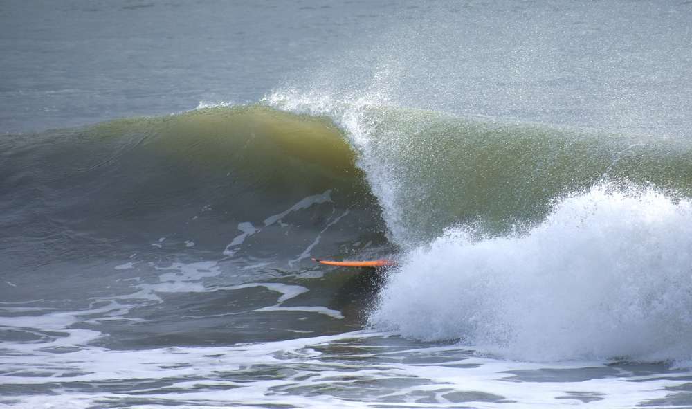
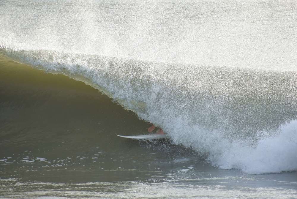
Paddled out this evening. definite hurricane swell has arrived! Was super drifty, hard paddle, long line super close outs. Bigger than it looked from beach. 3-5 feet. Gonna be much bigger 2morrow. Stay safe. Hope it stays off the coast. |
|
|
|
|
|
08/01/2020 01:09 AM
|
|
|
4 am Sat. Windy, using the ECMWF, has the hurricane's eye staying just off the coast until it ducks inland to do a direct hit on KSC, then goes back offshore north of Flagler Beach. That's unlikely to be exactly what plays out, but it's weird.
|
|
|
|
|
|
08/01/2020 02:08 AM
|
|
|
NHC 5a.m. has shifted the forecast east about 25 miles offshore reflecting the now 310 degrees direction from 305. It has also slowed down even more.
|
|
|
|
|
|
08/01/2020 02:21 AM
|
|
|
Correction, direction is 315 degrees
|
|
|
|
|
|
08/01/2020 02:27 AM
|
|
|
Westerly sheer is really hammering it right now. Fingers crossed.
------------------------- ... |
|
|
|
|
|
08/01/2020 04:35 AM
|
|
|
Anyone boarding up?, With everything that's been going on I just don't seem to give a shit.
|
|
|
|
|
|
08/01/2020 04:50 AM
|
|
|
Go wind sheer! Go dry air!
Boarding up? No, don't need to, still have them up from last year!! ------------------------- Dora Hates You Edited: 08/01/2020 at 04:51 AM by dingpatch |
|
|
|
|
|
08/01/2020 05:08 AM
|
|
|
|
|
|
|
|
08/01/2020 04:58 AM
|
|
|
Make sure to attach one giant mask to your home to help with the curve of the storm.
|
|
|
|
|
|
08/01/2020 09:29 AM
|
|
|
Make sure to attach one giant mask to your home to help with the curve of the storm. Perfectly sensible now that the weather channel is referring to it as COVIDCANE 2020. Seriously, what in the actual fu... |
|
|
|
|
|
08/01/2020 10:15 AM
|
|
|
Mike's Weather Page
2 minutes ago Isaias barely hanging on... might be on life support. Few hours ahead critical if he wants to come back. Core is strong and pressure is low 987mb. Dry air in oranges and reds might prove too much. www.spaghettimodels.com Smoke em, if ya got em, , , , , And, , , , I just realized that the Forum "time" is an hour behind!!?? ------------------------- Dora Hates You Edited: 08/01/2020 at 10:20 AM by dingpatch |
|
|
|
|
|
08/01/2020 05:51 AM
|
|
|
Check the Ponce Inlet cam. The end result of hype.
------------------------- So if you are a surfer I wish you the prosperity that allows you more time to pursue the salt water dream, and the true happiness that comes from warm water, clean waves and the companionship of your fellow surfers. If you are an internet troll just spewing bs then f off. |
|
|
|
|
|
08/01/2020 06:44 AM
|
|
|
But its just going into the gulf right? And the islands will block it from coming north right? So said this thread. Dont need 2ndlight hype to pack Ponce.
------------------------- ... |
|
|
|
|
|
08/01/2020 06:49 AM
|
|
|
Looks really good up there as anyone would expect with the current swell direction and winds. Wind looks utterly dead up there.
------------------------- ... |
|
|
|
|
|
08/01/2020 09:01 AM
|
|
|
As WW pointed out earlier, Windy.com is based off the ECMWF by default. but you can also switch to GFS and NAM models as well. Plus, just realized today that you can set the "weather picker" (which you position over the spot you want to know about) to show wind gusts, rather than just the wind (which you can set to mph if you wish) going off of that, they are showing max wind gusts Sunday night around 54mph at 192&A1A area with 37 or so steady wind will be interesting to see how accurate that ends up being. |
|
|
|
|
|
08/01/2020 09:20 AM
|
|
|
Currently tracking to the left of the official forecast track. Left of Euro and close to last GFS run.
------------------------- ... |
|
|
|
|
|
08/01/2020 06:51 AM
|
|
|
ponce does look pretty great. too lazy to chase it though. &old. hope we get some good surf and that blob stays off the coast.
Hope everyone scores if it happens. |
|
|
|
|
|
08/01/2020 09:24 AM
|
|
|
Saturday report. wind wasn't too strong early this morning but around 11am some clouds moved thru and that's it. Too windy. Size looked around 3-5 feet. Super choppy long line closeouts. Not that many people out. Doesn't look worth it in Satty.
|
|
|
|
|
|
08/01/2020 10:22 AM
|
|
|
you can change your profile time in settings. Adjust for daylight savings or whatever we are in.
|
|
|
|
|
|
08/01/2020 10:39 AM
|
|
|
Dave, I got the time corrected. Set on "Eastern Time", with -2.0 hours. Not sure why.
------------------------- Dora Hates You |
|
|
|
|
|
08/01/2020 12:17 PM
|
|
|
Went out in the NSB area until 130 pm . There was not a breath of air moving for the longest time , still only minimal south wind at 2pm . Water was turquoise and nice shoulder to head high lines . Supposed to stay calm until evening . Enjoy the calm before the storm.
|
|
|
|
|
|
08/01/2020 01:29 PM
|
|
|
how did so many weather folks miss this dry air that just ripped this storm to shreds?
------------------------- "The power of accurate observation is commonly called cynicism by those who do not have it." - George Bernard Shaw |
|
|
|
|
|
08/01/2020 01:31 PM
|
|
|
Levi did talk about it for awhile on last light's http://www.tropicaltidbits.com video.. he's the only guy I heard mention it |
|
|
|
|
|
08/01/2020 01:43 PM
|
|
|
Looked like a desert sky here the last two days.
------------------------- ... |
|
|
|
|
|
08/01/2020 02:12 PM
|
|
|
that saharan dust cloud up here too.
|
|
|
|
|
|
08/01/2020 02:18 PM
|
|
|
As of the 5 pm Advisory #Isaias has been downgraded to a tropical Storm but may regain hurricane status later tonight and Sunday. Stay with
https://www.nhc.noaa.gov/refresh/graphics_at4+shtml/205732.shtml?cone
------------------------- Waiting for waves is ok......most people spend their lives waiting for nothing. |
|
|
|
|
|
08/01/2020 04:15 PM
|
|
|
I'm kind of hoping it goes over brevard and we can experience the eye of the hurricane! It is interesting. I've been in a few.
|
|
|
|
|
|
08/01/2020 05:06 PM
|
|
|
5+ hours in the water (some good surf) followed by cold beer + playoff hockey..... good day. I'm toast

|
|
|
|
|
|
08/01/2020 08:42 PM
|
|
|
Just tracked inland. I'm out of hope.
------------------------- "One of the reasons why propaganda tries to get you to hate government is because it's the one existing institution in which people can participate to some extent and constrain tyrannical unaccountable power." Noam Chomsky. |
|
|
|
|
|
08/01/2020 10:07 PM
|
|
|
what are you looking at Johnnyboy? |
|
|
|
|
|
08/02/2020 01:47 AM
|
|
Edited: 08/02/2020 at 02:26 AM by ww |
|
|
|
|
|
08/02/2020 05:46 AM
|
|
|
It's offshore and crank'in down PB way already-Earlier than expected?!
------------------------- ola ~ |
|
|
|
|
|
08/02/2020 06:09 AM
|
|
|
The 8 AM radar and satellite are quite different from each other. WFTV showed the "official" location, the radar and the satellite. Well, the "location" is in the middle of the cloud "blow up" shown in the satellite. BUT, the radar shows an actual "circular'" motion that looks to be about 30+ miles to the ENE of the "official location!!?? Is it making a "jog" to the East!!??
The "official" spot is more-or-less between Delray Beach and Freeport, while the radar "circulation" seems to be forming over the NW tip of Freeport?? And now, the satellite does look like the "center" is over the NW tip of Freeport 
------------------------- Dora Hates You Edited: 08/02/2020 at 06:16 AM by dingpatch |
|
|
|
|
|
08/02/2020 07:21 AM
|
|
|
There are currently two spins. There is a surface circulation. Northeast of that there is a mid level circulation that had developed in that extremely intense convective burst in the northeast quadrant. The official position is tied to the surface low. If the Miami radar would quit blinking out you could see the surface circulation better. It is hidden on the latest satellite by the very large cloud shield emanating from that convective complex north of Grand Bahama.
------------------------- ... |
|
|
|
|
|
08/02/2020 10:36 AM
|
|
|
This thing might be even with Brevard by dark. Actually, at second glance, it's well before dark.
This all-over-the-place forecasting has me slightly concerned. The wishy-washy stuff won't cut it when a killer is headed our way. I guess GTFO early is the only option. ------------------------- I was right. |
|
|
|
|
|
08/02/2020 02:13 PM
|
|
|
Palm beach county got two maybe three hours of clean head high surf. Or so I've heard.
------------------------- "One of the reasons why propaganda tries to get you to hate government is because it's the one existing institution in which people can participate to some extent and constrain tyrannical unaccountable power." Noam Chomsky. |
|
|
|
|
|
08/02/2020 03:37 PM
|
|
|
The 20 miler: 50 knot gusts, seas 15 feet at 10 seconds.
------------------------- I was right. |
|
|
|
|
|
08/02/2020 04:13 PM
|
|
|
White water out to the horizon. Pretty cool looking.
------------------------- I was right. |
|
|
|
|
|
08/02/2020 04:32 PM
|
|
|
Getting some decent gusts in S Mel Beach right now. I'd take a guess and say the gusts around around 50 mph? Anybody have accurate readings? |
|
|
|
|
|
08/02/2020 05:31 PM
|
|
|
Also Mel beach, Iwindsurf.com shows some gusts to upper 40s at the inlet. Just back from dog walk, he was not amused...
------------------------- add a signature since I'm here in profile anyway |
|
|
|
|
|
08/02/2020 10:14 PM
|
|
|
GFS beat the EURO and UKMET on this storm. Going to be really wet here in Virginia on Tuesday. Baroclinic forcing is going to rule the day up here.
------------------------- ... |
|
|
|
|
|
08/02/2020 10:25 PM
|
|
|
------------------------- ... |
|
|
|
|
|
08/03/2020 02:51 AM
|
|
|
early cam visual looks like it already dropped like a rock
|
|
|
|
|
|
08/03/2020 02:52 AM
|
|
|
early cam visual looks like it already dropped like a rock maybe its just the tide or the wind |
|
|
|
|
|
08/03/2020 04:20 AM
|
|
|
------------------------- https://www.instagram.com/dj_kaye_/ |
|
|
|
|
|
08/03/2020 04:51 AM
|
|
|
still a bit "disorganized" up here

|
|
|
|
|
|
08/03/2020 06:27 AM
|
|
|
Surf is meh. Some size, but with a south component. Nothing great, hopefully it's just morning sickness.
------------------------- I was right. |
|
|
|
|
|
08/03/2020 08:55 AM
|
|
|
Enough fun ones out there to make it worth it. Hopefully something left for the lower tide
|
|
|
|
|
|
08/03/2020 09:22 AM
|
|
|
Is any one else stuck at work till the afternoon like me? Makes me think of the one homie that post on here with us "WORKSUXGETSPONSORD"!!!
Just got the "OK" from the boss, and leaving work at 330pm.. Hoping the winds stay offshore and the pier is still fun around 5pm ------------------------- SK8 AND DESTROY |
|
|
|
|
|
08/03/2020 10:19 AM
|
|
|
------------------------- ... |
|
|
|
|
|
08/03/2020 11:00 AM
|
|
|
<<==not this morning! (Again). Just got back to my oar here, it was firing out there and still good when I left, pretty consistent too. Amazing from such a weak storm so close, swell still appears to be ESE, so maybe this pulse is from last week. Hope you get some.
|
|
|
|
|
|
08/03/2020 11:04 AM
|
|
|
I thought it was pumping at the spot that I went to. But my standards are low.
Still clean and form is good out there, swell dropping but not too bad. Gonna recharge for the afternoon |
|
|
|
|
|
08/03/2020 11:44 AM
|
|
|
Yes! I was wrong! A few outside barrels in cocoa Beach? That's pretty damn rare.
I am not used to four hours in the water. ------------------------- I was right. |
|
|
|
|
|
08/03/2020 11:44 AM
|
|
|
Oh, and it's still chest plus and clean for those of you looking to ditch work.
------------------------- I was right. |
|
|
|
|
|
08/03/2020 01:02 PM
|
|
|
Glad the storm didn't have today's structure yesterday. Looks like it is nearing hurricane strength in the radar imagery and there is intense comvection on the west side.
------------------------- ... |
|
|
|
|
|
08/03/2020 01:27 PM
|
|
|
Definitely got better mid-morning to 1500hrs.
Lower tide helped the rocks in Satty beach area.
Winds would go lite and then ramp up about every 30 mins.
Still good but a lil softer.
------------------------- Waiting for waves is ok......most people spend their lives waiting for nothing. |
|
|
|
|
|
08/03/2020 01:49 PM
|
|
|
North of the Cape was the call...
|
|
|
|
|
|
08/03/2020 04:17 PM
|
|
|
Yea, i imagine the secret wildlife place was the call.
Our local break with three people out was fine by be. The South Brevard beaches kinda got the shaft. ------------------------- I was right. |
|
|
|
|
|
08/03/2020 04:55 PM
|
|
|
Any other spots experience a visit from a rather large white shark today? It cleared the lineup twice late this afternoon at our break in north Satellite... have never seen a dorsal fin that big in all my years of surfing here!
------------------------- 
|
|
|
|
|
|
08/03/2020 05:07 PM
|
|
|
Still some left for the after work crew..Wind stayed offshore until 6, yesss...
|
|
|
|
|
|
08/03/2020 05:56 PM
|
|
|
Speaking of spot north it is now 20 bucks for a day pass. I went up there on Friday to surf and unturned at the gate.
Surf was pretty fun today. (Monday). |
|
|
|
|
|
08/03/2020 06:49 PM
|
|
|
BULLETIN Hurricane Isaias Intermediate Advisory Number 27A...Corrected NWS National Hurricane Center Miami FL AL092020 800 PM EDT Mon Aug 03 2020 Corrected to add extent of hurricane-force winds and surface ob ...ISAIAS REGAINS HURRICANE STRENGTH AND IS EXPECTED TO MAKE LANDFALL TONIGHT WITH DANGEROUS WINDS AND STORM SURGE... ...STRONG WINDS AND HEAVY RAINFALL LIKELY FROM THE EASTERN CAROLINAS TO THE MID-ATLANTIC COAST TONIGHT AND TUESDAY... |
|
|
|
|
|
08/04/2020 02:56 AM
|
|
|
It went good to really good yesterday. So stoked!! Surfed like 4 hrs. one water break. Towards the later afternoon I was a bit drained and the incoming tide was still throwing big waves.
|
|
|
|
|
|
08/04/2020 03:38 AM
|
|
|
very happy from saturday's and yesterdays surf - especially since our passports are worthless lol
------------------------- https://www.instagram.com/dj_kaye_/ |
|
|
|
|
|
08/04/2020 06:48 AM
|
|
|
Had a blast. Made up for a lot of down time.
------------------------- "One of the reasons why propaganda tries to get you to hate government is because it's the one existing institution in which people can participate to some extent and constrain tyrannical unaccountable power." Noam Chomsky. |
|
|
|
|
|
08/04/2020 08:04 AM
|
|
|
Fun stuff this morn.

|
|
|
|
|
|
08/05/2020 07:20 AM
|
|
|
No Hype just fact, Monday morning was going off, shackfest all morning
------------------------- The Wavecaster Edited: 08/05/2020 at 07:21 AM by Tiptime |
|
|
|
|
|
FORUMS
:
Surfing
:
Is it to early to start up the Hype train ?
|
Topic Tools |
FuseTalk Basic Edition - © 1999-2024 FuseTalk Inc. All rights reserved.