
 |
2nd Light Forums |
 |
 |  |


|
Topic Title: TD #8. T.S. Henri Topic Summary: Nice spot for a storm to flare up! Created On: 08/16/2021 04:36 AM |
Linear : Threading : Single : Branch |
 |
- Central Floridave | - 08/16/2021 04:36 AM |
|
- Cole | - 08/16/2021 05:16 AM |
|
- Central Floridave | - 08/16/2021 06:45 AM |
|
- Plan B | - 08/16/2021 10:19 AM |
|
- chopola | - 08/16/2021 11:03 AM |
|
- Plan B | - 08/16/2021 03:15 PM |
|
- Central Floridave | - 08/16/2021 03:23 PM |
|
- Central Floridave | - 08/17/2021 08:05 AM |
|
- Central Floridave | - 08/17/2021 08:12 AM |
|
- Plan B | - 08/17/2021 08:56 AM |
|
- RiddleMe | - 08/17/2021 09:19 AM |
|
- Plan B | - 08/17/2021 09:28 AM |
|
- Central Floridave | - 08/17/2021 11:49 AM |
|
- Plan B | - 08/17/2021 01:43 PM |
|
- Central Floridave | - 08/17/2021 02:42 PM |
|
- StirfryMcflurry | - 08/17/2021 02:58 PM |
|
- Central Floridave | - 08/17/2021 03:11 PM |
|
- scombrid | - 08/17/2021 05:55 PM |
|
- Central Floridave | - 08/17/2021 07:31 PM |
|
- equipeola | - 08/18/2021 01:10 AM |
|
- johnnyboy | - 08/17/2021 08:22 PM |
|
- Central Floridave | - 08/18/2021 03:07 AM |
|
- Central Floridave | - 08/18/2021 03:10 AM |
|
- mp2115 | - 08/18/2021 04:35 AM |
|
- Plan B | - 08/18/2021 04:39 AM |
|
- Plan B | - 08/18/2021 06:03 AM |
|
- 3rdworldlover | - 08/18/2021 06:10 AM |
|
- StirfryMcflurry | - 08/18/2021 06:17 AM |
|
- chopola | - 08/18/2021 07:09 AM |
|
- Plan B | - 08/18/2021 08:58 AM |
|
- johnnyboy | - 08/18/2021 08:45 AM |
|
- Plan B | - 08/18/2021 08:56 AM |
|
- SrfGtr | - 08/18/2021 09:01 AM |
|
- jdbman | - 08/18/2021 09:25 AM |
|
- seaspray | - 08/18/2021 09:33 AM |
|
- Plan B | - 08/18/2021 09:44 AM |
|
- Plan B | - 08/18/2021 09:54 AM |
|
- Greensleeves | - 08/18/2021 10:19 AM |
|
- Central Floridave | - 08/18/2021 01:42 PM |
|
- havanabama | - 08/18/2021 02:07 PM |
|
- mp2115 | - 08/19/2021 03:50 AM |
|
- Central Floridave | - 08/18/2021 02:13 PM |
|
- Central Floridave | - 08/19/2021 02:04 PM |
|
- Central Floridave | - 08/19/2021 02:05 PM |
|
- jdbman | - 08/19/2021 04:28 PM |
|
- Central Floridave | - 08/18/2021 02:14 PM |
|
- RiddleMe | - 08/18/2021 02:23 PM |
|
- Plan B | - 08/18/2021 04:46 PM |
|
- rc | - 08/18/2021 06:04 PM |
|
- Greensleeves | - 08/19/2021 08:22 AM |
|
- Central Floridave | - 08/19/2021 08:23 AM |
|
- tom | - 08/19/2021 08:31 AM |
|
- Plan B | - 08/19/2021 09:45 AM |
|
- mp2115 | - 08/19/2021 09:50 AM |
|
- long_flaco1 | - 08/19/2021 09:51 AM |
|
- seaspray | - 08/19/2021 11:39 AM |
|
- eastcoastersrule | - 08/19/2021 12:25 PM |
|
- Central Floridave | - 08/19/2021 12:40 PM |
|
- long_flaco1 | - 08/19/2021 12:24 PM |
|
- Central Floridave | - 08/19/2021 12:42 PM |
|
- Cole | - 08/19/2021 01:03 PM |
|
- Plan B | - 08/19/2021 01:59 PM |
|
- Kimo63 | - 08/19/2021 06:53 PM |
|
- mp2115 | - 08/20/2021 03:41 AM |
|
- RiddleMe | - 08/20/2021 04:01 AM |
|
- Plan B | - 08/20/2021 04:08 AM |
|
- mp2115 | - 08/20/2021 04:29 AM |
|
- KP | - 08/20/2021 04:47 AM |
|
- Central Floridave | - 08/20/2021 04:34 AM |
|
- KP | - 08/20/2021 04:44 AM |
|
- pumphouse | - 08/20/2021 05:35 AM |
|
- RiddleMe | - 08/20/2021 05:39 AM |
|
- mp2115 | - 08/20/2021 05:42 AM |
|
- Greensleeves | - 08/20/2021 05:53 AM |
|
- Cole | - 08/20/2021 06:39 AM |
|
- Central Floridave | - 08/20/2021 06:59 AM |
|
- Cole | - 08/20/2021 07:05 AM |
|
- Plan B | - 08/20/2021 08:09 AM |
|
- seaspray | - 08/20/2021 09:30 AM |
|
- scombrid | - 08/20/2021 10:07 AM |
|
- johnnyboy | - 08/20/2021 10:15 AM |
|
- Central Floridave | - 08/20/2021 10:28 AM |
|
- IamSAW2 | - 08/20/2021 10:48 AM |
|
- StirfryMcflurry | - 08/20/2021 11:08 AM |
|
- surferclimber | - 08/20/2021 11:15 AM |
|
- surferclimber | - 08/20/2021 12:09 PM |
|
- Greensleeves | - 08/20/2021 11:32 AM |
|
- havanabama | - 08/20/2021 01:24 PM |
|
- Cole | - 08/20/2021 03:22 PM |
|
- JBSURF | - 08/20/2021 04:06 PM |
|
- Central Floridave | - 08/21/2021 06:47 AM |
|
- chopola | - 08/21/2021 07:46 AM |
|
- Cole | - 08/21/2021 08:02 AM |
|
- StirfryMcflurry | - 08/21/2021 04:12 PM |
|
- Plan B | - 08/22/2021 07:27 AM |
|
- StirfryMcflurry | - 08/28/2021 05:17 AM |
|
- Central Floridave | - 08/21/2021 09:47 AM |
|
- johnnyboy | - 08/21/2021 05:00 PM |
|
- mp2115 | - 08/23/2021 04:16 AM |
 Topic Tools Topic Tools
|

 08/16/2021 04:36 AM 08/16/2021 04:36 AM


|
|
|
Tropical Depression Eight Discussion Number 2
NWS National Hurricane Center Miami FL AL082021 500 AM AST Mon Aug 16 2021 Satellite imagery and radar data from Bermuda indicate that the tropical depression located about 100 nmi east of Bermuda has been moving southward and also remains a sheared tropical cyclone -- the ongoing saga of the Atlantic basin thus far this hurricane season. Convection has increased and developed closer to the center and a late-arriving ASCAT-C overpass indicated surface winds of 26-27 kt to the south of the well-defined circulation center. Based on those data, the slightly improved convective structure noted in both satellite and radar data, and satellite classifications of T2.0/30 kt, the initial intensity has been increased to 30 kt. The initial motion estimate is 195/04 kt. The small cyclone is starting to make the clockwise turn toward the south-southwest and eventually southwest that the global and regional models have been advertising the past couple of days. The latest NHC model guidance now shows less of a turn to the northwest after 72 hours, with the exception of the GFS, GFS-ensemble, and HMON models, which continue to take the cyclone northward and northeastward around Bermuda on day 4 and 5. The latest NHC track forecast is similar to the previous advisory track through 60 hours, and then widens the track slightly thereafter, but still shows a complete clockwise turn. This track scenario is to the right of the consensus models at all forecast periods, and is of low confidence on days 4 and 5. The vertical wind shear is forecast to remain at or below 10 kt for the next 36 hours or so, and that is most likely the time when the cyclone will strengthen. Thereafter, an increase in the shear to 20 kt or more is expected to cap the intensification process. The HWRF model turn the cyclone into a major hurricane by 72 hours, but this scenario is considered to be an extreme outlier given the amount of shear forecast to affect the system on days 3-5. So far this season, the HWRF model has been very shear resistant and has had a high intensity bias. The official intensity forecast closely follows a blend of the IVCN and HCCA consensus models through 60 hours, and then is below those models due to the high-bias contribution of the HWRF model. FORECAST POSITIONS AND MAX WINDS INIT 16/0900Z 32.4N 62.9W 30 KT 35 MPH 12H 16/1800Z 31.6N 63.1W 35 KT 40 MPH 24H 17/0600Z 31.0N 63.7W 40 KT 45 MPH 36H 17/1800Z 30.7N 64.5W 45 KT 50 MPH 48H 18/0600Z 30.7N 65.5W 50 KT 60 MPH 60H 18/1800Z 30.8N 66.7W 55 KT 65 MPH 72H 19/0600Z 31.1N 68.0W 55 KT 65 MPH 96H 20/0600Z 32.0N 69.0W 55 KT 65 MPH 120H 21/0600Z 34.0N 68.5W 55 KT 65 MPH Edited: 08/17/2021 at 08:03 AM by Central Floridave |
|
|
|
|
|
08/16/2021 05:16 AM
|
|
|
Satellite imagery and radar data from Bermuda indicate that the
tropical depression located about 100 nmi east of Bermuda has been moving southward That should mean swell from a good direction, as for the winds? ------------------------- I was right. |
|
|
|
|
|
08/16/2021 06:45 AM
|
|
|
So, far models keep it weak. But, NHC saying possible 65mph. Virtual buoys show nothing so far. Of course with a weak storm the majority of the wind is not pointed at Central Florida. Moving towards us of course helps, but need the NE wind fetch in the top NW quadrant of the storm to generate swell to us. Keep an eye. Hope NHC is correct in strengthening, but models keep it weak on Monday model runs.
So far this year the past storms long range forecast have been off. Look at Grace for an example. Also, the long range models on earlier storms were off. As usual. |
|
|
|
|
|
08/16/2021 10:19 AM
|
|
|
|
|
|
|
|
|
08/16/2021 11:03 AM
|
|
|
a 35mph storm moving s/w is better than a 75mph storm moving n/e.
|
|
|
|
|
|
08/16/2021 03:15 PM
|
|
|
|
|
|
|
|
|
08/16/2021 03:23 PM
|
|
|
Tropical Storm Henri Discussion Number 4
NWS National Hurricane Center Miami FL AL082021 500 PM AST Mon Aug 16 2021 Deep convection has persisted near and southeast of the center of the small tropical cyclone today, and subjective Dvorak intensity estimates were a consensus T2.5 (35 kt) at 1800 UTC. Objective estimates from ADT and SATCON also support tropical storm status, therefore the depression has been upgraded to a 35-kt tropical storm with this advisory. Henri (ahn-REE) becomes the eighth named storm of the 2021 Atlantic hurricane season. This is the fourth-earliest eighth storm on record with only 2020, 2005, and 1936 having the eighth-named storm form earlier in the season. Henri is located over warm waters, but is currently being affected by light to moderate northerly shear and dry mid-level air in the surrounding environment. Although these conditions are not overly conducive for strengthening, most of the intensity guidance supports gradual intensification over the next 24 to 48 hours. After that time, a significant increase in northeasterly upper-level winds is depicted by the global models over the system, which is likely to halt further strengthening. In fact, given the small size of Henri, it is likely to be more susceptible to the increase in shear, and it could weaken faster than indicated below. The HWRF remains more aggressive, but given the expected increase in shear, that solution still does not seem likely. The NHC intensity forecast is in best agreement with the LGEM model, and is slightly below the IVCN intensity consensus. The tropical storm is moving south-southwestward or 200/6 kt. Henri is forecast to move west-southwestward during the next 12-24 hours around the southeastern side of a mid-tropospheric high over the western Atlantic. After that time, Henri should turn westward as the ridge shifts eastward to the north of the tropical cyclone, and after 72 hours Henri is expected to approach the western extent of the ridge and should turn northward and then north-northeastward. The dynamical model guidance is in somewhat better agreement during the next 48-72 hours, but there remains some spread later in the period as to how sharp of northward turn occurs. The new NHC track forecast is similar to the previous advisory and lies near the center of the guidance envelope. FORECAST POSITIONS AND MAX WINDS INIT 16/2100Z 31.0N 62.9W 35 KT 40 MPH 12H 17/0600Z 30.5N 63.4W 40 KT 45 MPH 24H 17/1800Z 30.3N 64.2W 45 KT 50 MPH 36H 18/0600Z 30.2N 65.4W 50 KT 60 MPH 48H 18/1800Z 30.2N 66.9W 50 KT 60 MPH 60H 19/0600Z 30.3N 68.5W 50 KT 60 MPH 72H 19/1800Z 30.5N 69.9W 45 KT 50 MPH 96H 20/1800Z 31.8N 70.2W 45 KT 50 MPH 120H 21/1800Z 34.2N 68.4W 45 KT 50 MPH |
|
|
|
|
|
08/17/2021 08:05 AM
|
|
|
BULLETIN
Tropical Storm Henri Advisory Number 7 NWS National Hurricane Center Miami FL AL082021 1100 AM AST Tue Aug 17 2021 ...HENRI HOLDING STEADY IN STRENGTH SOUTH-SOUTHEAST OF BERMUDA... SUMMARY OF 1100 AM AST...1500 UTC...INFORMATION ----------------------------------------------- LOCATION...30.4N 64.3W ABOUT 135 MI...215 KM SSE OF BERMUDA MAXIMUM SUSTAINED WINDS...50 MPH...85 KM/H PRESENT MOVEMENT...WSW OR 255 DEGREES AT 6 MPH...9 KM/H MINIMUM CENTRAL PRESSURE...1004 MB...29.65 INCHES DISCUSSION AND OUTLOOK ---------------------- At 1100 AM AST (1500 UTC), the center of Tropical Storm Henri was located near latitude 30.4 North, longitude 64.3 West. Henri is moving toward the west-southwest near 6 mph (9 km/h). A faster motion toward the west is forecast by tonight, followed by a motion to the west-northwest or northwest by late Thursday. On the forecast track, the center of Henri should pass well to the south of Bermuda through tonight. Maximum sustained winds remain near 50 mph (85 km/h) with higher gusts. Some strengthening is possible during the next day or so. Tropical-storm-force winds extend outward up to 35 miles (55 km) from the center. The estimated minimum central pressure is 1004 mb (29.65 inches). Tropical Storm Henri Discussion Number 7 NWS National Hurricane Center Miami FL AL082021 1100 AM AST Tue Aug 17 2021 Henri remains a sheared tropical storm. Geostationary satellite images and microwave data show a relatively large area of deep convection (~200 miles across), but the center of the storm is located near the western edge of the thunderstorms due to ongoing northwesterly vertical wind shear. The latest Dvorak estimates have been steady at 3.0/45 kt from TAFB and SAB, and based on that data, the initial intensity is held at 45 kt. The center of Henri is located roughly 130 miles south-southeast of Bermuda currently, and this will likely be as close as the storm gets to the island. The tropical storm is gradually turning to the west, as expected, and the initial motion is estimated to be 255/5 kt. A subtropical ridge over the western Atlantic is building eastward to the north of Henri, and this feature should steer the storm westward at a slightly faster pace during the next two or three days. After that time, the ridge is expected to weaken and shift farther east as a cut off low or negatively-tilted trough develops over the northeast U.S. This change in the steering pattern should cause Henri to turn northeastward between Bermuda and the east coast of the U.S in the 72-120 h period. The NHC track forecast is a little faster than the previous one in the short term and farther west than the previous one from days 3-5, trending toward the latest consensus models. The northwesterly shear currently affecting Henri is expected to subside later today, and that should allow the storm to gain strength during the next 12-24 hours. However, a round of moderate northerly shear is expected to setup over Henri during the 24-96 hour period. Although this shear would typically cause some weakening, the combination of warm SSTs and increasing mid-level moisture could offset the negative influences of the shear. Therefore, no change in strength is predicted beyond the 24 h period. Some of the models suggest that the shear could lessen again this weekend, so although not explicitly forecast, some strengthening is possible then. FORECAST POSITIONS AND MAX WINDS INIT 17/1500Z 30.4N 64.3W 45 KT 50 MPH 12H 18/0000Z 30.4N 65.1W 50 KT 60 MPH 24H 18/1200Z 30.3N 66.5W 55 KT 65 MPH 36H 19/0000Z 30.3N 68.2W 55 KT 65 MPH 48H 19/1200Z 30.4N 69.7W 55 KT 65 MPH 60H 20/0000Z 30.7N 70.6W 55 KT 65 MPH 72H 20/1200Z 31.6N 71.3W 55 KT 65 MPH 96H 21/1200Z 34.1N 69.6W 55 KT 65 MPH 120H 22/1200Z 37.4N 66.0W 55 KT 65 MPH |
|
|
|
|
|
08/17/2021 08:12 AM
|
|
|
fyi, the virtual buoys haven't really shown any swell from Henri for Central Florida. Pains me to think we won't get anything. I imagine Hatteras will, maybe the virtual buoys wrong and we will. Or, the models just haven't got accurate data yet. I guess we gotta wait-and-see on the real buoys if we do. I guess most of the wind isn't pointed at us, but with the storm moving towards us currently you would think we would.
May have to do some old school voodoo magic to get a swell out of Henri. Or Travel North. |
|
|
|
|
|
08/17/2021 08:56 AM
|
|
|
forecast models all showing fetch/ energy on ENE side of the storm pointing away from us (pretty common with these small storms)..... hopefully they're wrong. We should get a small something friday, but looks like this is a time for the OBX and LI....
Edited: 08/17/2021 at 08:56 AM by Plan B |
|
|
|
|
|
08/17/2021 09:19 AM
|
|
|
|
|
|
08/17/2021 09:28 AM
|
|
|
That's whats been giving me hope.... maybe the small diameter is the issue
|
|
|
|
|
|
08/17/2021 11:49 AM
|
|
|
Tuesday afternoon model runs do now show a small ground swell for Friday. Didn't in the morning model runs. Hopefully, it gets a little bigger than forecasted!
|
|
|
|
|
|
08/17/2021 01:43 PM
|
|
|
yep... each update has a bit of an uptick.... I have the morning off friday, so fingers crossed
|
|
|
|
|
|
08/17/2021 02:42 PM
|
|
|
NHC 5pm update, now saying from 60 to 80mph in long range! Cat 1 possible...
Tropical Storm Henri Discussion Number 8 NWS National Hurricane Center Miami FL AL082021 500 PM AST Tue Aug 17 2021 Henri appears to be gaining strength. Satellite images show banding features becoming increasingly curved, especially on the east side of the system, and an eye feature has been occasionally seen in radar images from Bermuda. The upper-level outflow is also well established to the north and east of the center. The center itself is estimated to be located near the western edge of the convection, but it is possible that a new center is forming farther east. The initial intensity is raised to 55 kt following the Dvorak classification from TAFB. The initial wind radii has been expanded outward based on an earlier ASCAT pass. The tropical storm appears to have slowed down, and the latest initial motion estimate is 255/2 kt. A subtropical ridge over the western Atlantic is building eastward to the north of Henri, and this feature should steer the storm westward at a slightly faster pace during the next two to three days. After that time, the ridge is expected to weaken and shift farther east as a cut off low or negatively-tilted trough develops over the northeast U.S. This change in the steering pattern should cause Henri to turn northeastward between Bermuda and the east coast of the U.S in the 72-120 h period. There is a fair amount of spread in exactly when and where Henri makes this turn and the GFS and EC ensembles have some members not far offshore of New England and Atlantic Canada. Overall, the guidance has shifted westward again this cycle, and the NHC track forecast has been adjusted accordingly from days 3 to 5. The northwesterly shear currently affecting Henri is subsiding, which should allow the storm to gain a little more strength tonight. However, a round of moderate northerly shear is expected to setup over Henri on Wednesday and Thursday and that will likely temporarily end the opportunity for strengthening. Although this shear would typically cause some weakening, the combination of warm SSTs and increasing mid-level moisture could offset the negative influences of the shear. By Friday and over the weekend, the shear is expected to lessen again and since the other environmental factors are predicted to remain favorable for the storm, strengthening is shown from days 3-5. This forecast is above the previous one, and lies fairly close to the middle of the guidance envelope. FORECAST POSITIONS AND MAX WINDS INIT 17/2100Z 30.4N 64.2W 55 KT 65 MPH 12H 18/0600Z 30.3N 65.5W 60 KT 70 MPH 24H 18/1800Z 30.2N 67.0W 60 KT 70 MPH 36H 19/0600Z 30.2N 68.6W 60 KT 70 MPH 48H 19/1800Z 30.3N 70.0W 60 KT 70 MPH 60H 20/0600Z 31.0N 71.1W 60 KT 70 MPH 72H 20/1800Z 32.0N 71.5W 65 KT 75 MPH 96H 21/1800Z 35.5N 69.6W 70 KT 80 MPH 120H 22/1800Z 39.1N 65.2W 70 KT 80 MPH Edited: 08/17/2021 at 02:42 PM by Central Floridave |
|
|
|
|
|
08/17/2021 02:58 PM
|
|
|
|
|
|
|
|
|
08/17/2021 03:11 PM
|
|
|
I can only imagine those virtual buoy readings go up on the next day's model runs! That's what we do now, not predict the surf, predict when the models are going to predict the surf.
|
|
|
|
|
|
08/17/2021 05:55 PM
|
|
|
It is double secret since it is on the internet but if you aren't watching for Friday and Saturday morning you are a nincompoop. Mrs. Scombrid wants to take our dogs to the NSI dogs beach on Saturday AM. I pulled my kitchen pass yesterday. I hope it wasn't too soon and I didn't jinx it. I may be wrong. But I doubt it.
------------------------- ... Edited: 08/17/2021 at 05:58 PM by scombrid |
|
|
|
|
|
08/17/2021 07:31 PM
|
|
|
18zulu model runs made a major change! Check the forecast now!
|
|
|
|
|
|
08/18/2021 01:10 AM
|
|
|
------------------------- ola ~ |
|
|
|
|
|
08/17/2021 08:22 PM
|
|
|
It's got the same characteristics as Kyle did.
------------------------- "One of the reasons why propaganda tries to get you to hate government is because it's the one existing institution in which people can participate to some extent and constrain tyrannical unaccountable power." Noam Chomsky. |
|
|
|
|
|
08/18/2021 03:07 AM
|
|
|
00Z model runs (Wed morning) still doesn't make this a major swell maker. hmm...Strange.
|
|
|
|
|
|
08/18/2021 03:10 AM
|
|
|
Tropical Storm Henri Discussion Number 10
NWS National Hurricane Center Miami FL AL082021 500 AM AST Wed Aug 18 2021 There's been little change in Henri's satellite appearance this morning. The surface center is still located just to the northwest of a gradually expanding central dense overcast, and there still appears to be an eye-like feature in the Bermuda Doppler radar presentation. However, there are no indications in the GOES-16 BD-curve enhanced infrared images of a developing warm spot. Subjective and objective satellite intensity estimates remain steady, and the initial intensity is held at 55 kt for this advisory. Although the surrounding thermodynamic environment is ripe for further significant development, moderate northwesterly shear continues to impinge on the cyclone causing difficulty in inner-core convective development. Consequently, little change in strength is expected during the next couple days, and in fact the statistical SHIPS model indicates an increase in a more northerly shear component on Thursday. By Saturday afternoon, however, the shear should decrease as the cyclone slides beneath an upper ridge axis off of the southeast U.S. coast. Henri is expected to further intensity through the remaining period as the upper-wind flow becomes much more diffluent. The official intensity forecast is similar to the previous advisory, and lies between the SHIPS model and the HFIP Corrected Consensus Approach aid after the 60-hour period. The initial motion is estimated to be westward, or 260/7 kt. A high amplitude mid- to upper-level anticyclone situated north-northeast of Henri should steer the cyclone toward the west during the next 36 hours, or so. Thereafter, the aforementioned ridge is forecast to weaken and shift eastward in response to a mid-latitude shortwave trough moving over the northeastern U.S. As a result of the change in the synoptic steering pattern, Henri should turn toward the northwest, north, and then northeast through the remaining portion of the forecast. With so much uncertainty or spread in the global and regional models beyond day 3, the best approach at this point is to base the NHC forecast on the better performing multi-model consensus guidance, which has once again shifted a bit to the left of the previous track forecast. I think it's worth noting that the GFSv16 model is now showing a shortwave ridge building over eastern Canada on Sunday, which causes Henri to move more northward toward the New England coast. Therefore, additional changes or shifts of the track beyond the 60-hour period may be required on subsequent advisories. Due to the increased uncertainty in the track forecast, interests along the New England coast should monitor the progress of Henri. FORECAST POSITIONS AND MAX WINDS INIT 18/0900Z 30.1N 65.7W 55 KT 65 MPH 12H 18/1800Z 29.9N 66.9W 60 KT 70 MPH 24H 19/0600Z 29.8N 68.7W 60 KT 70 MPH 36H 19/1800Z 29.8N 70.6W 60 KT 70 MPH 48H 20/0600Z 30.4N 71.8W 60 KT 70 MPH 60H 20/1800Z 31.4N 72.3W 65 KT 75 MPH 72H 21/0600Z 33.0N 71.9W 70 KT 80 MPH 96H 22/0600Z 37.6N 69.0W 75 KT 85 MPH 120H 23/0600Z 40.5N 66.1W 65 KT 75 MPH |
|
|
|
|
|
08/18/2021 04:35 AM
|
|
|
Appears we should get some type of a swell from Henri.
|
|
|
|
|
|
08/18/2021 04:39 AM
|
|
|
|
|
|
|
|
|
08/18/2021 06:03 AM
|
|
|
If GFS forecast holds =

|
|
|
|
|
|
08/18/2021 06:10 AM
|
|
|
2-4' @ 11-12 seconds Friday afternoon per GFS wave model
|
|
|
|
|
|
08/18/2021 06:17 AM
|
|
|
|
|
|
|
|
|
08/18/2021 07:09 AM
|
|
|
The internet told me to be hopeful. The internet told me to forget about it. Open your eyes, figure it out for yourself.
|
|
|
|
|
|
08/18/2021 08:58 AM
|
|
|
|
|
|
|
|
|
08/18/2021 08:45 AM
|
|
|
I will go!!!! Then I will decide about the internet.
------------------------- "One of the reasons why propaganda tries to get you to hate government is because it's the one existing institution in which people can participate to some extent and constrain tyrannical unaccountable power." Noam Chomsky. |
|
|
|
|
|
08/18/2021 08:56 AM
|
|

|
|
|
|
|
|
08/18/2021 09:01 AM
|
|
|
I literally walk across the street half dozen times a day to look at the actual wave I'm going to surf . I still spend hours a day on the net looking at predictions and cams. Stop worrying about what I do. If everyone stopped telling peeps what to do on social media Maybe folks wouldn't b so angry when they get in the water w actual surf. LOL ... and if me telling u to stop telling me what to do is part of the problem then ur hopeless.
|
|
|
|
|
|
08/18/2021 09:25 AM
|
|
|
Does anyone think the positioning of Henri in any way resembles Kyle?
------------------------- So if you are a surfer I wish you the prosperity that allows you more time to pursue the salt water dream, and the true happiness that comes from warm water, clean waves and the companionship of your fellow surfers. If you are an internet troll just spewing bs then f off. |
|
|
|
|
|
08/18/2021 09:33 AM
|
|
|
Wavemaker, yeah
I love that track, felt like we haven't had one of these in a while |
|
|
|
|
|
08/18/2021 09:44 AM
|
|
|
|
|
|
|
|
|
08/18/2021 09:54 AM
|
|
|
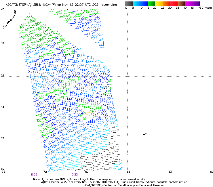
ASCAT finally made a pass in the region.... you can see the windfield is pretty small (tiny compared to Grace) so moving west to 72+ will greatly increase size potential for our surf.....
  still excited about the potential to able to ride a regular shortboard though still excited about the potential to able to ride a regular shortboard though Edited: 08/18/2021 at 09:56 AM by Plan B |
|
|
|
|
|
08/18/2021 10:19 AM
|
|
|
yes to the "regular shortboard". Been riding my 5'!!" Neilson thruster if it gets any push. mega shakas...
|
|
|
|
|
|
08/18/2021 01:42 PM
|
|
|
Virtual buoys finally responded with better data. Check your favorite wave models (unless you are chopola and just stick your finger in the air for wind direction and wait to see people run across A1A with boards to know there are waves.
|
|
|
|
|
|
08/18/2021 02:07 PM
|
|
|
Why do the tides have to ruin the party?
------------------------- Ah, religion, bigotry dressed up as morality. |
|
|
|
|
|
08/19/2021 03:50 AM
|
|
|
|
|
|
|
|
|
08/18/2021 02:13 PM
|
|
|
Tropical Storm Henri Discussion Number 12
NWS National Hurricane Center Miami FL AL082021 500 PM AST Wed Aug 18 2021 Henri appears a little better organized this afternoon. The storm still has a central dense overcast pattern and there have been hints of an eye evident in visible satellite images. Microwave images continue to show a mid-level eye feature, but the storm does not appear quite as well organized in the low-levels, and the vortex is still titled southward with height. The latest Dvorak estimates range from 55 to 67 kt, and based on that data the initial intensity is nudged up to 60 kt, just below hurricane strength. Henri is moving just south of due west at a slightly faster pace now, 265/8 kt. The storm is expected to continue westward for another 36 hours or so as it moves in the flow on the south side of a mid-level ridge. A gradual turn to the north is forecast to begin on Friday when a cutoff low forms over the Ohio Valley and the northeastern U.S. This general northward motion should continue through the weekend as another ridge builds to the east of Henri over the northwestern Atlantic. The models continue their westward shift, and the NHC track forecast has again been adjusted in that direction and no longer shows a northeastward motion out to sea. In particular, the westward adjustment at day 5 was a sizable 150 miles, and even with this shift the NHC forecast is still a little to the east of some of the consensus aids. NOAA Gulfstream IV missions and special weather balloon soundings have been scheduled, and it is hoped that this additional data will help the models handle the evolving steering pattern. Given the uncertainty in the longer range track forecast, users should be prepared for additional adjustments to the NHC track prediction in future forecast cycles. The storm is currently in an environment of about 15-20 kt of northerly wind shear according to the SHIPS model and analyses from CIMSS at the University of Wisconsin, which is the reason the vortex is currently titled. The shear should persist for another day or so, and little change in strength seems likely during that time period. However, strengthening is expected on Friday and Saturday as the shear decreases while the storm remains over the Gulf Stream. Some weakening seems likely at days 4 and 5 when the storm is expected to be over cooler waters. The NHC intensity forecast lies roughly near the middle of the guidance envelope and only minor changes were made to the previous prediction. Key Messages: 1. The forecast track of Henri has shifted toward the northeast coast of the U.S. this weekend and early next week, increasing the risk of direct storm surge, wind, and rain impacts in portions of the northeastern U.S. and Atlantic Canada during that time. Interests in these areas should closely follow the progress of Henri and check for updates to the forecast. 2. Swells from Henri will begin to reach much of the east coast of the U.S. and Atlantic Canada by the end of the week and continue through the weekend. These swells could cause life-threatening surf and rip currents. FORECAST POSITIONS AND MAX WINDS INIT 18/2100Z 29.9N 67.6W 60 KT 70 MPH 12H 19/0600Z 29.8N 69.0W 60 KT 70 MPH 24H 19/1800Z 29.8N 70.7W 60 KT 70 MPH 36H 20/0600Z 30.1N 72.3W 65 KT 75 MPH 48H 20/1800Z 31.0N 73.2W 70 KT 80 MPH 60H 21/0600Z 32.7N 72.7W 75 KT 85 MPH 72H 21/1800Z 35.2N 71.7W 80 KT 90 MPH 96H 22/1800Z 39.3N 70.0W 70 KT 80 MPH 120H 23/1800Z 41.4N 69.8W 60 KT 70 MPH |
|
|
|
|
|
08/19/2021 02:04 PM
|
|
|
Tropical Storm Henri Advisory Number 16
NWS National Hurricane Center Miami FL AL082021 500 PM EDT Thu Aug 19 2021 ...HENRI EXPECTED TO STRENGTHEN ON FRIDAY AND OVER THE WEEKEND... ...INTERESTS IN THE NORTHEASTERN U.S. SHOULD MONITOR ITS PROGRESS... SUMMARY OF 500 PM EDT...2100 UTC...INFORMATION ---------------------------------------------- LOCATION...29.7N 71.4W ABOUT 450 MI...720 KM SSE OF CAPE HATTERAS NORTH CAROLINA ABOUT 800 MI...1285 KM S OF NANTUCKET MASSACHUSETTS MAXIMUM SUSTAINED WINDS...65 MPH...100 KM/H PRESENT MOVEMENT...W OR 270 DEGREES AT 10 MPH...17 KM/H MINIMUM CENTRAL PRESSURE...997 MB...29.44 INCHES WATCHES AND WARNINGS -------------------- There are no coastal watches or warnings in effect. Interests in the northeastern U.S. and Atlantic Canada should monitor the progress of Henri. Watches will likely be required for a portion of this area early Friday. DISCUSSION AND OUTLOOK ---------------------- At 500 PM EDT (2100 UTC), the center of Tropical Storm Henri was located near latitude 29.7 North, longitude 71.4 West. Henri is moving toward the west near 10 mph (17 km/h) and this motion is expected to through tonight. A turn toward the northwest is forecast on Friday, followed by an acceleration toward the north and north-northeast Saturday and Sunday. On the forecast track, the center of Henri will remain well offshore of the east coast of the United States over the next couple of days, but it is forecast to be near southern New England on Sunday and Monday. Maximum sustained winds are near 65 mph (100 km/h) with higher gusts. Little change in strength is expected during the next 12 to 24 hours, but Henri is forecast to intensify into a hurricane by Friday night with additional strengthening expected this weekend. Tropical-storm-force winds extend outward up to 90 miles (150 km) from the center. The estimated minimum central pressure is 997 mb (29.44 inches). HAZARDS AFFECTING LAND ---------------------- RAINFALL: Henri may produce rainfall amounts of 2 to 5 inches over southeastern New England Sunday into Monday, with isolated maximum totals near 8 inches. Heavy rainfall from Henri may result in areas of flash, urban, and small stream flooding. SURF: Swells generated by Henri should continue to affect Bermuda during the next day or so. Swells are expected to increase across much of the east coast of the U.S. and Atlantic Canada later this week and this weekend. These swells could cause life-threatening surf and rip current conditions. Please consult products from your local weather office. NEXT ADVISORY ------------- Next complete advisory at 1100 PM EDT. |
|
|
|
|
|
08/19/2021 02:05 PM
|
|
|
Tropical Storm Henri Discussion Number 16
NWS National Hurricane Center Miami FL AL082021 500 PM EDT Thu Aug 19 2021 The Air Force Hurricane Hunters investigated Henri earlier this afternoon and found maximum flight-level winds and SFMR values to support an intensity of about 55 kt and a minimum pressure of 997 mb. The storm's appearance in satellite images has been generally steady throughout the day with the low-level center located on the northern side of the convective mass, and banding features confined to the south side of the circulation. This somewhat asymmetric cloud pattern is due to about 25 kt of north-northeasterly shear. The tropical storm is now moving due westward at 9 kt. A mid-level ridge should keep Henri on a westward to west-northwestward track through tonight. On Friday, however, a trough is expected to cut off over the Ohio Valley and mid-Atlantic region of the U.S. while a ridge amplifies to the east of Henri over the western Atlantic. A combination of these features should cause Henri to turn northward on Friday and accelerate in that direction over the weekend. The exact location of the northward turn will be very critical in determining Henri's future track and how close it gets to New England. The latest GFS run has shifted eastward and the UKMET and ECMWF have shifted westward. Consequently, the net result is very little change in the consensus models and the new NHC track forecast is just a little faster than the previous one. Based on this forecast, Henri is expected to be very near southern New England on Sunday and Monday. The NOAA Gulfstream IV jet will be flying around Henri this evening to help assess the environmental conditions and gather data for the numerical models. It is hoped that these data will help the models more accurately predict the future track of the storm. Although Henri is a bit weaker now, the overall intensity forecast philosophy has not changed. The shear is expected to persist for another 12 to 24 hours, so little change in strength seems likely during that time period. However, the global models show a more conducive upper-level wind pattern over Henri shortly after that, and in fact, all of the environmental conditions appear favorable for strengthening on Friday and Saturday. Therefore, steady intensification is expected during the 24-60 h time period, and Henri is forecast to become a hurricane during that time. Henri is expected to cross the north wall of the Gulf Stream and move over much cooler SSTs on Sunday, and that should end the opportunity for strengthening and induce a steady weakening trend from days 3 to 5. Post-tropical transition is now shown to occur by the end of the forecast period when Henri is expected to be over SSTs below 20 deg C. It should be noted that as Henri gains latitude and moves near New England, the wind field is expected to expand. Therefore, users are reminded to not focus on the exact forecast points as impacts will extend far from the center. Key Messages: 1. Henri is forecast to be near the northeast coast of the U.S. on Sunday and Monday, and the risks of storm surge, wind, and rain impacts in portions of southern New England and eastern Long Island are increasing. Watches will likely be required for portions of this area early Friday. 2. Swells from Henri will begin to reach much of the east coast of the U.S. and Atlantic Canada by the end of the week and continue through the weekend. These swells could cause life-threatening surf and rip currents. 3. Heavy rainfall may lead to flash, urban, and small stream flooding over portions of southeastern New England Sunday into Monday. FORECAST POSITIONS AND MAX WINDS INIT 19/2100Z 29.7N 71.4W 55 KT 65 MPH 12H 20/0600Z 30.1N 72.6W 55 KT 65 MPH 24H 20/1800Z 31.0N 73.2W 55 KT 65 MPH 36H 21/0600Z 33.0N 72.6W 65 KT 75 MPH 48H 21/1800Z 36.0N 71.3W 75 KT 85 MPH 60H 22/0600Z 38.9N 70.3W 80 KT 90 MPH 72H 22/1800Z 40.8N 70.1W 65 KT 75 MPH 96H 23/1800Z 42.3N 69.6W 50 KT 60 MPH 120H 24/1800Z 43.6N 65.7W 40 KT 45 MPH...POST-TROPICAL |
|
|
|
|
|
08/19/2021 04:28 PM
|
|
|
Little ping on the 20
8/19/21 730pm ------------------------- So if you are a surfer I wish you the prosperity that allows you more time to pursue the salt water dream, and the true happiness that comes from warm water, clean waves and the companionship of your fellow surfers. If you are an internet troll just spewing bs then f off. |
|
|
|
|
|
08/18/2021 02:14 PM
|
|
|
Sunrise Surfer Swell! R.I.P. Dan. Everyone catch one or three for him.
|
|
|
|
|
|
08/18/2021 02:23 PM
|
|
|
Sunrise Surfer Swell! R.I.P. Dan. Everyone catch one or three for him. I expect nothing less than the set of the day from everyone. |
|
|
|
|
|
08/18/2021 04:46 PM
|
|

|
|
|
|
|
|
08/18/2021 06:04 PM
|
|
|
Sunrise Surfer Swell! R.I.P. Dan. Everyone catch one or three for him. Henri is the Dan swell for sure. Some very sad surfers on here. My best Dan Moment: March 2013 coming in from an RCs session, Dan's driving by at the street crossing moment beeping his horn, thumbs up! Total stoke as always. |
|
|
|
|
|
08/19/2021 08:22 AM
|
|
|
There are good sandbars at all tides available...
|
|
|
|
|
|
08/19/2021 08:23 AM
|
|
|
Sucks 120 mile canaveral buoy is not reporting swell height and period. Guess gotta keep refreshing 41009! Unless you are chopola...
|
|
|
|
|
08/19/2021 08:31 AM

|
|
|
Is that a hint of hype I detect in the air?
------------------------- add a signature since I'm here in profile anyway |
|
|
|
|
|
08/19/2021 09:45 AM
|
|
|
OBX is going to be pretty sick this weekend..... I probably need to trade my 2 old trucks for one new one, one of these days....
|
|
|
|
|
|
08/19/2021 09:50 AM
|
|
|
|
|
|
|
|
|
08/19/2021 09:51 AM
|
|
|
One moe "Sunrise Surfer Momment" I also wanted to share with my 2ndlight familia.
So I made my "Adult Comeback" to surfing after a 10+ year hiatus through the teen years, and had just joined 2ndlight surf forum (around 2003) so I was up to speed on all forecasted incoming swells. A Random hurricane sent MASSIVE swell to Brevard county 10' + faces (I want to say BARY?)! I was literally SHITTING MY PANTS looking at sets break.. I'd say at least 50-75 yards outside of the end of the pier, constantly refreshing the surfline cam and SUPER doubting my skill level at that point (only like 1.5 years into this comeback).. I watched a surfer STRAIGHT UP AND DOWN OWN a sick one waaay over his head from the back all the way in! THIS WAS my moment of clarity to say to myself, I CAN SURF THAT!!! I Surfed my freaking face off that day, caught (what I called) a 12' foot face on the north side of the pier, biggest waves I've surfed to this day so far! Came back home and of course checked 2ndlight dot com to see all the images.. Low and behold, there was a pic of Sunrise on a big ass wave on that day and I specifically remember the stance\demeanor of the surfer that pumped me up to GO FOR IT! IT WAS DAN!! The big homie was stoke'n peoples brains out when he wasn't even trying! Will miss seeing him in the lineup for sure.. "Here is to THE SUNRISE SURFER SWELL" TOMORROW bros n bras! ------------------------- SK8 AND DESTROY |
|
|
|
|
|
08/19/2021 11:39 AM
|
|
|
Just checked the streets and nothing yet. There's something spinning in the middle of the ocean but it's still small out there
|
|
|
|
|
|
08/19/2021 12:25 PM
|
|
|
Here's the Heritage Surf Shop Report (Ocean City, NJ):
Friday looks super fun as SE swell will be in the 3-4? range @11 seconds with light winds.
Should be a great day, as well as Saturday, with the swell increasing as the storm approaches the waters off of Hatteras. Winds will depend on proximity of the storm but as of right now it looks favorable for us to see solid surf with light (onshore) winds.
Sunday could be overhead and firing, but we could also see stiff NE winds - too far out to claim so stay tuned.
Edited: 08/19/2021 at 12:27 PM by eastcoastersrule |
|
|
|
|
|
08/19/2021 12:40 PM
|
|
|
E.Hatty buoy showing major uptick this afternoon.
https://www.ndbc.noaa.gov/stat...page.php?station=41001 |
|
|
|
|
|
08/19/2021 12:24 PM
|
|
|
Dangit..
Just checked the 20 mile buoy, and the 1 mile buoy, both are at 1' foot at 10 seconds! ------------------------- SK8 AND DESTROY |
|
|
|
|
|
08/19/2021 12:42 PM
|
|
|
7 feet and 10 seconds from the SE angle. That ain't coming our way.
Wish had E.Cana buoy, but guess gotta wake up and be a Sunrise Surfer tomorrow! |
|
|
|
|
|
08/19/2021 01:03 PM
|
|
|
The thing is sitting on our front porch and we ain't getting nada.
I saw a little log wave that wasn't here this morning, so... HYPE! ------------------------- I was right. |
|
|
|
|
|
08/19/2021 01:59 PM
|
|
|
we'll get some waves, but i wouldnt be pulling the pintail from the rafters...... unless you're headed a several hundred miles NORTH
|
|
|
|
|
|
08/19/2021 06:53 PM
|
|
|
Better ping now. 1.6 feet at 10 sec ENE . we have an inbound swell
|
|
|
|
|
|
08/20/2021 03:41 AM
|
|
|
One guy out a the Pier looking slow
|
|
|
|
|
|
08/20/2021 04:01 AM
|
|
|
Not much this morning. Worse it's high tide
Edited: 08/20/2021 at 04:01 AM by RiddleMe |
|
|
|
|
|
08/20/2021 04:08 AM
|
|
|
Hello 9-6 log, we meet yet again....
|
|
|
|
|
|
08/20/2021 04:29 AM
|
|
|
Well, should pickup a bit and be fun. Lets get after it. I got my 9'0" Neilson Hawaiian. I'm sure there will be the occasional paddle paddle to the outside sets.
|
|
|
|
|
|
08/20/2021 04:47 AM
|
|
|
Hello 9-6 log, we meet yet again.... Lol I immediately imagined up a skit opening garage and dusting off longboard as an older Simon and Garfunkel are standing on each side singing those lyrics. 
------------------------- Time and tide wait for no one..... |
|
|
|
|
|
08/20/2021 04:34 AM
|
|
|
Checked the cams, yes, high tide and small. Should be an uptick bigger by noon. Low at 1pm. Wind is currently favorable with afternoon onshore predicted. I'm going surfing once the tide moves out some.
I've got a couple friends up in Hatteras and another one at cape cod. Can't wait to see what they get. |
|
|
|
|
|
08/20/2021 04:44 AM
|
|
|
Thanks for the vizzies.
Sorry guys. I think it was me. I was too excited and waxed up my new midlength last night. Hopefully the bump up will come soon. ------------------------- Time and tide wait for no one..... |
|
|
|
|
|
08/20/2021 05:35 AM
|
|
|
and in Jupiter area.......hello flatness my old friend
On another note, is Magic Seaweed the worst forecast site out there, they have Jupiter area listed at 3-5 today at Noon, If that happens I will dance the irish jig ------------------------- "The power of accurate observation is commonly called cynicism by those who do not have it." - George Bernard Shaw |
|
|
|
|
|
08/20/2021 05:39 AM
|
|
|
Now we have something on the 20 that might not require a log when the tide drops a bit
|
|
|
|
|
|
08/20/2021 05:42 AM
|
|
 Southern Brevard Southern Brevard
|
|
|
|
|
|
08/20/2021 05:53 AM
|
|
|
AN hour maybe? Surfed CB streets. Tide high not terrible. Things to come should be good.
|
|
|
|
|
|
08/20/2021 06:39 AM
|
|
|
Checked several spots from Cocoa Beach to South Patrick and there wasn't much going on. There was a little peak at O'Club, but the 60 plus people in the water swarming for two foot grovellers wasn't very appealing. I'll check again in an hour as the tide falls, but it's looking like we got the shaft again.
------------------------- I was right. |
|
|
|
|
|
08/20/2021 06:59 AM
|
|
|
Just saw something. See ya'll out there. Wear some kind of sun protection. It's a scorcher today..
|
|
|
|
|
|
08/20/2021 07:05 AM
|
|
|
A slight bump up at the buoy, but it needs to show before the wind. The ocean is hot and the land is hot, with any luck it's a draw and the wind will stay still.
------------------------- I was right. Edited: 08/20/2021 at 07:05 AM by Cole |
|
|
|
|
|
08/20/2021 08:09 AM
|
|
|
I'm pretty sure there may be an invisible underwater wave-shield surrounding St. Augustine.....
|
|
|
|
|
|
08/20/2021 09:30 AM
|
|
|
Was fun at Satellite towards lunchtime
|
|
|
|
|
|
08/20/2021 10:07 AM
|
|
|
I have fun this morning on the little clean stuff. Two good sets in the whole two hours but I got a really good wave out of each. Kind of think the peak size is going to be this evening but I don't think the seabreeze is going to be that bad. Might be fun even with a little texture.
------------------------- ... |
|
|
|
|
|
08/20/2021 10:15 AM
|
|
|
I was hoping for more size. Log it is.
------------------------- "One of the reasons why propaganda tries to get you to hate government is because it's the one existing institution in which people can participate to some extent and constrain tyrannical unaccountable power." Noam Chomsky. |
|
|
|
|
|
08/20/2021 10:28 AM
|
|
|
Satellite was 2-4 feet in inconsistent long period swell. It was glassy until the wind turned onshore at noon. Caught a few fun ones. Good warm up for bigger stuff for the bigger surf to come into September/October (knock on wood).
|
|
|
|
|
|
08/20/2021 10:48 AM
|
|
|
<=Not today! Nice lil brunch/liquid lunch somewheres between tips spot and dave's, lol the secrets out today, hello Henry! Fun lil glassy waist to chest sets with refreshing upwelling cool spots, like Dave says a good warmup for Big (but hopefully not too big) September! and now, back to my oar....uggh!
Edited: 08/20/2021 at 10:48 AM by IamSAW2 |
|
|
|
|
|
08/20/2021 11:08 AM
|
|
|
AS PREDICTED - once the tide backed off this morning (north o the cape) the outer sandbar started breaking and it was magical fun on the LB for a couple hours
Edited: 08/20/2021 at 11:11 AM by StirfryMcflurry |
|
|
|
|
|
08/20/2021 11:15 AM
|
|
|
It's maybe 3' long period up here in Volusia and is breaking outside but barely - more longboard wave then cane swell. Still something to surf ; )
------------------------- get up early and go surf - it'll make that hangover go away and/or make the workday more tolerable :) |
|
|
|
|
|
08/20/2021 12:09 PM
|
|
|
Update: just came back from a quick session now the low tide has passed, quite a bit bigger sets coming in now on outside, inconsistent but there if you're patient! Probably peak of swell will be next low tide or tomorrow DP?? Still nice little bit of stoke to finish the week, and thank GOD the storm isn't pointed at us - hope those folks up NE plan accordingly & stay safe as it's been a longgggg time!
------------------------- get up early and go surf - it'll make that hangover go away and/or make the workday more tolerable :) Edited: 08/20/2021 at 12:10 PM by surferclimber |
|
|
|
|
|
08/20/2021 11:32 AM
|
|
|
Fun on streets. Shortboardable
|
|
|
|
|
|
08/20/2021 01:24 PM
|
|
|
I drove over for my Dan, Sunrise Surfer tribute. Paddled out at sunrise. Caught a few for Dan. Wish the swell had arrived sooner.
------------------------- Ah, religion, bigotry dressed up as morality. |
|
|
|
|
|
08/20/2021 03:22 PM
|
|
|
Yep, a decent wave at the secret Satellite break. Had there not been an additional 150 people, it would have been really fun.
------------------------- I was right. |
|
|
|
|
|
08/20/2021 04:06 PM
|
|
|
I heard the chatter about increasing swell as the day played out, soooooo, I check it and wait, sunrise, no paddle out, gonna get bigger later!! Check around 10, same thing, gonna get bigger I`ll save it for that.. Check after dead low, still glassy but closing pretty bad, and no real increase yet so I wait, check around 4:40, not bigger yet, dang, oh well I do finally paddle out and figure with the incoming tide push and more water, with light on shores will be the call, way more makable, so I wait pretty much the whole day and was abit underwhelmed, but there is some swell in the water and I had a blast. Here`s to you Sunrise Dan, RIP Bro
------------------------- I've decided to accept the fact - I'll always be a big kid! Edited: 08/20/2021 at 04:07 PM by JBSURF |
|
|
|
|
|
08/21/2021 06:47 AM
|
|
|
Still waves this saturday, but half the size. In retrospect the virtual buoys did get it right. Most of the wind fetch was on the other side of the storm and not pointed at us. Saw some photos of hatteras, looked pretty big there. Looks like Long Island may take a hit. Also, of note in this discussion is about how the eye may have stronger winds today in the NW quadrant. Maybe a sneaky NE swell from it the next couple of days, and maybe not.
Strange showings on swell models for mid-week, but is that SE angle?!? Something to watch. Glad I paddle out yesterday and got two hours in. I can tell you as getting older swimming 1/4 mile a day prior isn't enough to be in good surf shape. Nothing gets you in surf shape better than surfing. My Hammy wanted to cramp up on my last wave I caught after two hours. Prob due to it being 95F and two hours and approaching 60 years old combined. But, Inspired to get in better surf shape. Also, my first outside set wave was dedicated to Sunrise Surfer. I said thank You Dan as I got to my feet. It was a very fun wave. Tropical Storm Henri Discussion Number 22 NWS National Hurricane Center Miami FL AL082021 500 AM EDT Sat Aug 21 2021 An earlier GMI satellite microwave image continued to indicate that Henri's low-level center was still located near the northwestern edge of the convective canopy. However, more recent geostationary satellite imagery shows that the convection is beginning to wrap around the northeastern and eastern portions of the circulation suggesting that the anticipated decrease in shear is occuring, and that Henri may be on the verge of strengthening. The latest subjective satellite intensity estimates from SAB and TAFB remained unchanged so the initial intensity remains 60 kt, in agreement with those estimates and the earlier aircraft data. The next reconnaissance aircraft mission should be in the storm around 1200 UTC this morning. Henri is moving north-northeastward or 015/10 kt. A mid- to upper-level low and associated trough over the Appalachians and Ohio Valley should steer Henri north-northeastward at a faster forward speed today. As Henri moves around the eastern portion of the upper-low, the storm is forecast to turn north-northwestward tonight. This motion will bring the center of Henri near or over portions of Long Island and Southern New England on Sunday and into the northeastern United States Sunday night. After that time, the cyclone should turn east-northeastward as it becomes caught in the mid-latitude westerlies. The latest dynamical model envelope continues to narrow for the first 24 to 36 hours of the forecast period and only small adjustments were needed to that portion of the track. After that time, the guidance has trended to taking Henri farther inland over the Northeastern United States, and the NHC forecast as been modified accordingly. Decreasing shear, upper-level divergence associated with the trough to Henri's west, and warm SSTs should allow the cyclone to strengthen during the next 12-18 hours. Although not explicitly shown in the intensity forecast, Henri could still peak around 75 kt later today or this evening. After that time, cooler waters are likely to cause a gradual reduction in intensity, however, Henri is forecast to be at or near hurricane strength at landfall. Once the center moves inland over the Northeast United States, a faster rate of filling is anticipated. The system is forecast to become post-tropical in about 60 hours, and it will likely dissipate around day 4, if not a little sooner. The updated intensity forecast is near the upper-end of the intensity guidance during the first 12-24 hours, and is close to the Decay-SHIPS model thereafter. Users are reminded to not focus on the exact forecast of the center of Henri since impacts will extend far from the center. Key Messages: 1. Dangerous storm surge inundation is expected to begin late tonight or Sunday in portions of Long Island, Connecticut, Rhode Island, and southeastern Massachusetts, where a Storm Surge Warning has been issued. Dangerous storm surge is possible beginning late tonight or Sunday in western portions of Long Island and Connecticut in the Storm Surge Watch area. Residents in these areas should follow any advice given by local officials. 2. Hurricane conditions are expected to begin late tonight or Sunday in portions of Long Island and Connecticut, where a Hurricane Warning has been issued. Hurricane conditions are possible late tonight or Sunday across portions of Rhode Island. 3. Heavy rainfall may lead to considerable flash, urban, and small stream flooding, along with the potential for widespread minor and isolated moderate river flooding, over portions of Long Island, New England, southeast New York and northern New Jersey. 4. Swells from Henri will continue to affect much of the east coast of the U.S. through the weekend. These swells could cause life-threatening surf and rip currents. FORECAST POSITIONS AND MAX WINDS INIT 21/0900Z 33.1N 73.2W 60 KT 70 MPH 12H 21/1800Z 35.6N 72.3W 70 KT 80 MPH 24H 22/0600Z 38.8N 72.0W 70 KT 80 MPH 36H 22/1800Z 40.9N 72.7W 60 KT 70 MPH...INLAND 48H 23/0600Z 42.1N 73.6W 35 KT 40 MPH...INLAND 60H 23/1800Z 42.8N 73.3W 25 KT 30 MPH...POST-TROP/INLAND 72H 24/0600Z 43.3N 71.5W 25 KT 30 MPH...POST-TROP/INLAND 96H 25/0600Z 44.5N 62.5W 25 KT 30 MPH...POST-TROPICAL 120H 26/0600Z...DISSIPATED |
|
|
|
|
|
08/21/2021 07:46 AM
|
|
|
I guess I should have listened when the internet told me to forget about it.
|
|
|
|
|
|
08/21/2021 08:02 AM
|
|
|
A few spots in Satellite were really fun from 10:30 till noon.
I hope the next swell decides to be a little less specific. ------------------------- I was right. |
|
|
|
|
|
08/21/2021 04:12 PM
|
|
|
|
|
|
|
|
|
08/22/2021 07:27 AM
|
|
|
|
|
|
|
|
|
08/28/2021 05:17 AM
|
|
|
Edited: 08/28/2021 at 05:17 AM by StirfryMcflurry |
|
|
|
|
|
08/21/2021 09:47 AM
|
|
|
"I guess I should have listened when the internet told me to forget about it."
Old dogs can learn new tricks! |
|
|
|
|
|
08/21/2021 05:00 PM
|
|
|
Fort pierce was good, or at least me and 400 new friends thought so.
------------------------- "One of the reasons why propaganda tries to get you to hate government is because it's the one existing institution in which people can participate to some extent and constrain tyrannical unaccountable power." Noam Chomsky. |
|
|
|
|
|
08/23/2021 04:16 AM
|
|
|
|
|
|
|
|
|
FORUMS
:
Surfing
:
TD #8. T.S. Henri
|
Topic Tools |
FuseTalk Basic Edition - © 1999-2024 FuseTalk Inc. All rights reserved.