
 |
2nd Light Forums |
 |
 |  |


|
Topic Title: Here comes 12 / Larry? Topic Summary: This could be the one.... Created On: 08/31/2021 02:58 PM |
Linear : Threading : Single : Branch |
 |
- Plan B | - 08/31/2021 02:58 PM |
|
- LBLarry | - 08/31/2021 03:53 PM |
|
- Plan B | - 08/31/2021 05:19 PM |
|
- jdbman | - 09/01/2021 04:07 AM |
|
- Greensleeves | - 09/01/2021 06:08 AM |
|
- LaJune | - 09/01/2021 06:13 AM |
|
- Plan B | - 09/01/2021 08:13 AM |
|
- LBLarry | - 09/01/2021 11:30 AM |
|
- surferclimber | - 09/01/2021 07:18 PM |
|
- paddleout | - 09/01/2021 10:43 PM |
|
- Central Floridave | - 08/31/2021 04:02 PM |
|
- stokedpanda | - 09/01/2021 09:33 AM |
|
- rc | - 09/01/2021 04:03 PM |
|
- Plan B | - 09/01/2021 06:11 PM |
|
- johnnyboy | - 09/01/2021 04:03 PM |
|
- Central Floridave | - 09/02/2021 04:15 AM |
|
- Plan B | - 09/02/2021 04:56 AM |
|
- Central Floridave | - 09/02/2021 06:37 AM |
|
- RiddleMe | - 09/02/2021 07:29 AM |
|
- Plan B | - 09/02/2021 09:13 AM |
|
- mp2115 | - 09/02/2021 09:30 AM |
|
- RiddleMe | - 09/02/2021 10:01 AM |
|
- StirfryMcflurry | - 09/02/2021 10:29 AM |
|
- Plan B | - 09/02/2021 03:08 PM |
|
- Plan B | - 09/02/2021 04:55 PM |
|
- Long Beard | - 09/02/2021 09:39 AM |
|
- 1974 | - 09/02/2021 05:38 PM |
|
- ww | - 09/02/2021 09:00 PM |
|
- Cole | - 09/03/2021 07:07 AM |
|
- tom | - 09/03/2021 08:15 AM |
|
- Plan B | - 09/03/2021 08:23 AM |
|
- Central Floridave | - 09/03/2021 07:48 AM |
|
- Greensleeves | - 09/03/2021 07:58 AM |
|
- stokedpanda | - 09/03/2021 09:16 AM |
|
- StirfryMcflurry | - 09/03/2021 10:28 AM |
|
- long_flaco1 | - 09/03/2021 01:13 PM |
|
- Plan B | - 09/03/2021 06:58 PM |
|
- RiddleMe | - 09/04/2021 04:51 AM |
|
- mp2115 | - 09/04/2021 06:47 AM |
|
- Plan B | - 09/04/2021 09:54 AM |
|
- jdbman | - 09/07/2021 03:16 AM |
|
- Plan B | - 09/07/2021 04:13 AM |
|
- Central Floridave | - 09/07/2021 04:18 AM |
|
- jdbman | - 09/08/2021 04:26 PM |
|
- rc | - 09/04/2021 03:24 PM |
|
- Central Floridave | - 09/05/2021 08:55 PM |
|
- IamSAW2 | - 09/06/2021 06:26 AM |
|
- rc | - 09/04/2021 03:27 PM |
|
- StirfryMcflurry | - 09/04/2021 04:56 PM |
|
- Plan B | - 09/05/2021 04:11 AM |
|
- Plan B | - 09/05/2021 04:13 AM |
|
- Greensleeves | - 09/06/2021 06:59 AM |
|
- Plan B | - 09/06/2021 08:14 AM |
|
- Central Floridave | - 09/06/2021 08:18 AM |
|
- tom | - 09/06/2021 10:17 AM |
|
- Central Floridave | - 09/06/2021 10:45 AM |
|
- Lunchmeat | - 09/06/2021 12:21 PM |
|
- jdbman | - 09/06/2021 01:40 PM |
|
- Kimo63 | - 09/06/2021 02:05 PM |
|
- Central Floridave | - 09/06/2021 02:22 PM |
|
- seaspray | - 09/06/2021 03:57 PM |
|
- SrfGtr | - 09/06/2021 05:13 PM |
|
- seaspray | - 09/06/2021 05:20 PM |
|
- RocketSurf | - 09/06/2021 06:27 PM |
|
- Central Floridave | - 09/07/2021 04:23 AM |
|
- jdbman | - 09/07/2021 05:21 AM |
|
- Central Floridave | - 09/07/2021 05:58 AM |
|
- Central Floridave | - 09/07/2021 08:39 AM |
|
- Plan B | - 09/07/2021 09:55 AM |
|
- Central Floridave | - 09/07/2021 10:10 AM |
|
- Plan B | - 09/07/2021 10:29 AM |
|
- johnnyboy | - 09/07/2021 10:42 AM |
|
- IamSAW2 | - 09/07/2021 10:50 AM |
|
- KP | - 09/07/2021 08:46 PM |
|
- ww | - 09/08/2021 02:44 AM |
|
- mp2115 | - 09/08/2021 05:33 AM |
|
- seaspray | - 09/08/2021 05:58 AM |
|
- mp2115 | - 09/07/2021 10:51 AM |
|
- mp2115 | - 09/07/2021 11:02 AM |
|
- seaspray | - 09/07/2021 02:00 PM |
|
- Kimo63 | - 09/07/2021 02:36 PM |
|
- RiddleMe | - 09/07/2021 04:58 PM |
|
- wtf | - 09/07/2021 04:36 PM |
|
- chopola | - 09/07/2021 07:18 PM |
|
- ww | - 09/07/2021 07:39 PM |
|
- Central Floridave | - 09/08/2021 06:07 AM |
|
- tom | - 09/08/2021 06:50 AM |
|
- RiddleMe | - 09/08/2021 08:58 AM |
|
- Central Floridave | - 09/08/2021 09:05 AM |
|
- Plan B | - 09/08/2021 09:32 AM |
|
- seaspray | - 09/08/2021 10:30 AM |
|
- StirfryMcflurry | - 09/08/2021 11:35 AM |
|
- IamSAW2 | - 09/08/2021 12:11 PM |
|
- WG | - 09/08/2021 01:08 PM |
|
- RocketSurf | - 09/08/2021 03:06 PM |
|
- LBLarry | - 09/08/2021 03:20 PM |
|
- seaspray | - 09/08/2021 04:29 PM |
|
- Plan B | - 09/09/2021 02:12 AM |
|
- StirfryMcflurry | - 09/09/2021 02:42 AM |
|
- tom | - 09/09/2021 02:44 AM |
|
- scombrid | - 09/09/2021 03:01 AM |
|
- LaJune | - 09/08/2021 03:22 PM |
|
- mp2115 | - 09/09/2021 04:02 AM |
|
- Central Floridave | - 09/09/2021 10:25 AM |
|
- onebuck | - 09/09/2021 11:08 AM |
|
- johnnyboy | - 09/10/2021 11:23 AM |
|
- Greensleeves | - 09/10/2021 01:08 PM |
|
- equipeola | - 09/10/2021 02:04 PM |
|
- Plan B | - 09/12/2021 05:25 AM |
|
- johnnyboy | - 09/12/2021 05:43 AM |
 Topic Tools Topic Tools
|

 08/31/2021 02:58 PM 08/31/2021 02:58 PM


|
|
|
Could we finally have a solid swell producing "fish" storm? Looks like it. Doesnt look to get close enough to get huge, but I'll take some solid clean long period swell, esp after the past few years.... and I'll be happy to drive 10 minutes, not 10 hours for good surf too....
 60H 03/0600Z 13.3N 36.5W 70 KT 80 MPH
72H 03/1800Z 14.3N 39.0W 80 KT 90 MPH
96H 04/1800Z 16.5N 43.5W 85 KT 100 MPH
120H 05/1800Z 19.5N 47.5W 90 KT 105 MPH
60H 03/0600Z 13.3N 36.5W 70 KT 80 MPH
72H 03/1800Z 14.3N 39.0W 80 KT 90 MPH
96H 04/1800Z 16.5N 43.5W 85 KT 100 MPH
120H 05/1800Z 19.5N 47.5W 90 KT 105 MPH 
Edited: 08/31/2021 at 03:03 PM by Plan B |
|
|
|
|
|
08/31/2021 03:53 PM
|
|
|
Plan B .... I will do what I can for ya and speak to my other brother Larry
------------------------- "Most people would die sooner than think; in fact, they do." - Bertrand Russell "Morality is doing what is right, regardless of what you are told. Religion is doing what you are told, regardless of what is right. If I do not answer you .... nothing personal, I just have you on ignore. |
|
|
|
|
|
08/31/2021 05:19 PM
|
|
|
for the Newhart reference though
Edited: 08/31/2021 at 05:21 PM by Plan B |
|
|
|
|
|
09/01/2021 04:07 AM
|
|
|
000
WTNT42 KNHC 010858 TCDAT2 Tropical Storm Larry Discussion Number 3 NWS National Hurricane Center Miami FL AL122021 800 AM CVT Wed Sep 01 2021 Deep convection with cloud tops colder than -80C have increased over and to the west of the low-level center since the previous advisory. Subjective satellite intensity estimates at 0600 UTC from TAFB and SAB were T2.5/35 kt and T3.0/45 kt, while the most recent objective intensity estimates from UW-CIMSS are T2.8/41 kt from ADT and 37 kt from SATCON. An average of these intensity estimates support increasing the advisory intensity to 40 kt, making the cyclone Tropical Storm Larry. In addition, 0300 UTC and 0700 UTC observations from ship VRNF3, which recently passed through the center of Larry, reported a pressure of 1006.8 mb and winds near 25 kt. These data were the basis for the estimated central pressure of 1003 mb, a pressure value that also supports an intensity of 40 kt. Larry has turned more westward over the past several hours, and the new motion estimate is 280/17 kt. Larry is expected to move around the southern and southwestern periphery of the sprawling Bermuda-Azores ridge for the next 5 days, resulting in a general west motion for the next 36 hours or so, followed by a turn toward the west-northwest on Friday, and a northwestward motion over the weekend and continuing into early next week. There has been a pronounced westward shift in the track guidance for this cycle, with the greatest shift coming from the GFS model. Over the past 36 hours, the GFS has shifted its track westward by more than 500 nmi, and even the latest shift still keeps the GFS model the easternmost track forecast in the guidance suite. In contrast, the ECMWF and UKMET models, which lie along the westernmost portion of the guidance envelope, have been fairly stable. Owing to the westward shift in the overall guidance envelope, and considering the GFS solution as an outlier model, the new NHC forecast track has also been shifted westward, and lies between the NOAA-HCCA corrected-consensus model to the south, and the tightly packed TVCA simple-consensus model and FSSE corrected-consensus model to the north. Given the poor handling of the ridge to the north of Larry by the GFS, subsequent NHC forecast tracks may have to be shifted farther west. Given the improved inner-core wind field based on earlier ASCAT wind data and reports from ship VRNF3, along with warm sea-surface temperatures of 28 deg C and light easterly to southeasterly vertical shear of around 5 kt, steady strengthening is expected for the next 24 hours or so. By 36 hours when Larry is expected to be a hurricane and have a well-established and tighter inner-core wind field and possibly an eye, rapid intensification is forecast, with Larry becoming a major hurricane by 72 hour. This in large part due to the massive equatorward upper-level outflow pattern that all of the global and regional models are forecasting, which is the same type of outflow pattern that recently occurred with Hurricane Ida. The new official intensity forecast is above the previous advisory forecast by about 10 kt at all forecast times, and conservatively follows an average of the Decay-SHIPS, COAMPS-TC, FSSE, and ECMWF models. This intensity forecast is near the upper end of the guidance envelope and is above the other consensus intensity models. ------------------------- So if you are a surfer I wish you the prosperity that allows you more time to pursue the salt water dream, and the true happiness that comes from warm water, clean waves and the companionship of your fellow surfers. If you are an internet troll just spewing bs then f off. |
|
|
|
|
|
09/01/2021 06:08 AM
|
|

|
|
|
|
|
|
09/01/2021 06:13 AM
|
|
|
Man that 5AM update on Larry said everything a tropical swell starved surfer wants to hear.
------------------------- Heavy is sign of reliability |
|
|
|
|
|
09/01/2021 08:13 AM
|
|
|
Larry, tell your brother to SLOW DOWN! no need to be in such a rush....
|
|
|
|
|
|
09/01/2021 11:30 AM
|
|
|
Larry, tell your brother to SLOW DOWN! no need to be in such a rush.... Trying dude, trying. Talking to him about doing the Belle stall and slow crawl ------------------------- "Most people would die sooner than think; in fact, they do." - Bertrand Russell "Morality is doing what is right, regardless of what you are told. Religion is doing what you are told, regardless of what is right. If I do not answer you .... nothing personal, I just have you on ignore. |
|
|
|
|
|
09/01/2021 07:18 PM
|
|
|
The intensity guidance basically keeps a steady intensity from 60-120 h, and the official forecast follows that trend. However, this part of the intensity forecast is in the middle of the guidance, and it is possible Larry could be
stronger than forecast during this time.....
Sooooo are they saying just might be cat 10
------------------------- get up early and go surf - it'll make that hangover go away and/or make the workday more tolerable :) |
|
|
|
|
09/01/2021 10:43 PM

|
|
|
Major hurricane by Friday-wow.
Cat3 by Saturday. Here's hoping Larry stays far offshore. 
|
|
|
|
|
|
08/31/2021 04:02 PM
|
|
|
Wake me up when it happens. But, thanks for setting the alarm clock!
|
|
|
|
|
|
09/01/2021 09:33 AM
|
|
|
come on ride that train choochoo and ride it!
------------------------- I troll 2L.com to be a better person in real life |
|
|
|
|
|
09/01/2021 04:03 PM
|
|
|
I have an older brother named Larry, does that help?
|
|
|
|
|
|
09/01/2021 06:11 PM
|
|

|
|
|
|
|
|
09/01/2021 04:03 PM
|
|
|
It's gonna be good it's gonna be good it's gonna be good.
------------------------- "One of the reasons why propaganda tries to get you to hate government is because it's the one existing institution in which people can participate to some extent and constrain tyrannical unaccountable power." Noam Chomsky. |
|
|
|
|
|
09/02/2021 04:15 AM
|
|
|
Time to up the laps in the pool!
|
|
|
|
|
|
09/02/2021 04:56 AM
|
|
|
EURO predicting a tighter more intense storm (borderline cat4) but more importantly slower moving, giving us an extra day of swell..... GFS, slightly less intense, but broader windfield (good), but moving faster...... this year, GFS has seemed to be more accurate, but looks like NHC is siding with the EURO, so we'll see..... good waves either way, as long as local winds cooperate, still a week out, so we'll which day is worth playing hookey..... Yes, I am a nerd


Edited: 09/02/2021 at 04:58 AM by Plan B |
|
|
|
|
|
09/02/2021 06:37 AM
|
|
|
Check those virtual buoys! Wowsa... Yes, please be favorable local winds. We need this. been a long time since big swell around these parts.
|
|
|
|
|
|
09/02/2021 07:29 AM
|
|
|
Looking forward to the well over head 3 block long close outs.
|
|
|
|
|
|
09/02/2021 09:13 AM
|
|
|
|
|
|
|
|
|
09/02/2021 09:30 AM
|
|

|
|
|
|
|
|
09/02/2021 10:01 AM
|
|
|
Looking forward to the well over head 3 block long close outs. There's always "That guy" [IMG][/IMG] There will be some rainbows just gotta to some homework where this swell will break. [IMG]i/expressions/sun.gif" border="0[/IMG] I was serious. Any surf is better than no surf. Yes, I know where to go. I just don't want to drive and the place nearby that will break it up some will be a zoo. |
|
|
|
|
|
09/02/2021 10:29 AM
|
|
|
Does this mean... waves for NKF finals Monday?
|
|
|
|
|
|
09/02/2021 03:08 PM
|
|
|
Once Larry completes the ongoing ERC, significant or even rapid
intensification is anticipated. The short-term intensity forecast
has been raised a bit more, since it appears more likely the present
ERC will finish in the next 6-12 h. The latest NHC intensity
forecast now makes Larry a major hurricane by tomorrow night, with
further intensification up to Category 4 intensity anticipated by
Sunday. Once again, there remains some discrepancy in the vertical
wind shear forecast between the GFS- and ECMWF-based SHIPS guidance,
with the ECMWF forecasting significantly more southwesterly shear
beyond 72 hours. Both guidance tools also indicate a decrease in
mid-level relative humidity which, if the shear materializes, could
disrupt Larry's inner core structure. Thus, the NHC intensity
forecast still shows gradual weakening from 72 to 120 hours. The
latest intensity forecast is just a hair above HCCA in the short
term, with the intensity forecast most closely following the latest
COAMPS-TC (CTCI) guidance in the first three days
60H 05/0600Z 18.3N 48.6W 120 KT 140 MPH
 Looking VERY similar to this classic (name this storm... no cheating)

Edited: 09/02/2021 at 03:09 PM by Plan B |
|
|
|
|
|
09/02/2021 04:55 PM
|
|
|
|
|
|
|
|
09/02/2021 09:39 AM
|
|
|
Looking forward to the well over head 3 block long close outs. There's always "That guy" I mean he aint lying. ------------------------- R I P Mama G. @Salt.And.Savagery.Fishing @Laserwolf.Laserwolf |
|
|
|
|
|
09/02/2021 05:38 PM
|
|
|
Looking forward to the well over head 3 block long close outs. There's always "That guy" [IMG][/IMG] I mean he aint lying. Hahaha yeah I was going to say, "He has a point there.." ------------------------- Hi. I'm Mike. |
|
|
|
|
|
09/02/2021 09:00 PM
|
|

Edited: 09/03/2021 at 12:49 AM by ww |
|
|
|
|
|
09/03/2021 07:07 AM
|
|
|
Looking forward to the well over head 3 block long close outs. It might be far enough out to override our shitty Floridian luck for once. And it will be from the south so I'll be able to skip on RC's and the like. Our hood has a good bar too, if you know where to look. ------------------------- I was right. |
|
|
|
|
|
09/03/2021 08:15 AM
|
|
|
Predicted 16 sec period? I think 3 block closeouts may be conservative. Anticipation.
------------------------- add a signature since I'm here in profile anyway |
|
|
|
|
|
09/03/2021 08:23 AM
|
|
|
Spots that normally are mushy lazy waves may become good breaks.....of course also inlets and weird bends in the beach. I have a few local spots planned out in my head, but tides are a huge factor in surf quality for us up here.... with any luck it'll be big enough that tides dont matter
|
|
|
|
|
|
09/03/2021 07:48 AM
|
|
|
btw, speaking of Rc's. Since those twin ugly condos went up and the dredge and fill project, it ain't breaking like it use to. Just another break now.
|
|
|
|
|
|
09/03/2021 07:58 AM
|
|
|
We do Cole. This whole area set up. RCs will have 1000s of people there for old times sake.
|
|
|
|
|
|
09/03/2021 09:16 AM
|
|
|
would putting in for a day/days off jinx it? asking for a friend
------------------------- I troll 2L.com to be a better person in real life |
|
|
|
|
|
09/03/2021 10:28 AM
|
|
|
is your friend's name Larry? did they go to school with your Uncle? I'd say .....yep
|
|
|
|
|
|
09/03/2021 01:13 PM
|
|
|
Dangit! I just did this for Wednesday and Friday!! ------------------------- SK8 AND DESTROY |
|
|
|
|
|
09/03/2021 06:58 PM
|
|
 With the recent improvement in Larry's structure on satellite
imagery, the hurricane may be starting another rapid intensification
(RI) cycle, as suggested by the high RI probabilities given in the
DTOPS guidance. However, the earlier microwave data also suggested
that there were a lot of concentric bands outside of the primary
eyewall, and it is not out of the question that another eyewall
replacement cycle could begin in the next 24-36 hours. Instead
of attempting to forecast these often stochastic processes, the
latest NHC intensity forecast will instead show a healthy rate of
deepening over the next several days, now taking Larry to 120 kt in
48 hours. Afterwards, there still remain questions as to how much
the vertical wind shear will increase over Larry, with the
ECMWF-SHIPS indicating higher shear that could affect Larry's
inner-core structure, while the GFS-SHIPS showing much lower shear.
Warmer sea-surface temperatures also await the hurricane in the
60-96 hour period. Due to these competing factors, the intensity
forecast during this period will only show very gradual weakening.
The latest NHC intensity forecast remains on the high end of the
guidance, but still remains lower than the higher HAFS-B and
COAMPS-TC models. It should be noted that the majority of the
guidance also shows Larry becoming a very large hurricane, with a
significant expansion of the 34-, 50-, and 64-kt wind radii also
forecast.
Significant ocean swells generated by the increasingly large wind
field of Larry are expected to reach the Lesser Antilles on Sunday,
increasing the risk of life-threatening rip currents and high surf
conditions on those islands early next week. Large swells are likely
to spread to areas surrounding the western Atlantic later in the
week as well.
With the recent improvement in Larry's structure on satellite
imagery, the hurricane may be starting another rapid intensification
(RI) cycle, as suggested by the high RI probabilities given in the
DTOPS guidance. However, the earlier microwave data also suggested
that there were a lot of concentric bands outside of the primary
eyewall, and it is not out of the question that another eyewall
replacement cycle could begin in the next 24-36 hours. Instead
of attempting to forecast these often stochastic processes, the
latest NHC intensity forecast will instead show a healthy rate of
deepening over the next several days, now taking Larry to 120 kt in
48 hours. Afterwards, there still remain questions as to how much
the vertical wind shear will increase over Larry, with the
ECMWF-SHIPS indicating higher shear that could affect Larry's
inner-core structure, while the GFS-SHIPS showing much lower shear.
Warmer sea-surface temperatures also await the hurricane in the
60-96 hour period. Due to these competing factors, the intensity
forecast during this period will only show very gradual weakening.
The latest NHC intensity forecast remains on the high end of the
guidance, but still remains lower than the higher HAFS-B and
COAMPS-TC models. It should be noted that the majority of the
guidance also shows Larry becoming a very large hurricane, with a
significant expansion of the 34-, 50-, and 64-kt wind radii also
forecast.
Significant ocean swells generated by the increasingly large wind
field of Larry are expected to reach the Lesser Antilles on Sunday,
increasing the risk of life-threatening rip currents and high surf
conditions on those islands early next week. Large swells are likely
to spread to areas surrounding the western Atlantic later in the
week as well.
|
|
|
|
|
|
09/04/2021 04:51 AM
|
|
|
Actually liking the early high tide for this size and period
|
|
|
|
|
|
09/04/2021 06:47 AM
|
|
|
Hurricane Bill 2009 & Hurricane Katia 2011 are similar in strength and path. There are probably more but those two I've surfed both and are relatively recent on the timeline. Happy hunting everyone.
|
|
|
|
|
|
09/04/2021 09:54 AM
|
|
|
Edited: 09/04/2021 at 09:59 AM by Plan B |
|
|
|
|
|
09/07/2021 03:16 AM
|
|
|
From Surfline:
"Hurricane Bill (August 15th-26th, 2009) August 2009 was a fantastic time to be an East Coast surfer. Peaking as a large, category 4 hurricane, Bill basically took an ideal track for East Coast swell production. Florida and New England were notable standouts, but the entire coast saw days of swell from Bill. Similarities? Spawned from tropical wave off Africa and developed near Cape Verde Islands Became a long-lived, major hurricane Favorable recurving track over the Atlantic Differences? Bill tracked further west between Bermuda and the East Coast; Larry forecast to remain east of Bermuda Bill became a stronger and larger storm than Larry (so far) Bill peaked with hurricane-force winds extending up to 115 miles from the center, Larry's currently slightly weaker with hurricane-force winds only extending 70 miles from the center Hurricane Teddy (September 12th-24th, 2020) During the hyperactive 2020 season, Hurricane Teddy stood out as the main event for East Coast surf. Once it tracked past Bermuda, Teddy evolved differently than most recurving tropical systems. Large high pressure to the north and northeast of the system effectively expanded Teddy's wind field, and also made it take a left turn to the northwest, two factors that greatly enhanced Teddy's swell production. Swell Story: Teddy: The Most Popular Storm in Two Alphabets Similarities? Spawned from tropical waves off Africa and developed near Cabo Verde Islands Long-life, major hurricanes Tracked on the east side of Bermuda Differences? Teddy was massive, eventually becoming the fourth largest Atlantic hurricane on record Teddy underwent extratropical transition upon passing Bermuda, allowing the wind field to grow as it took a favorable northwest track ahead of a Nova Scotia landfall. Larry will likely race off to the northeast with no high-pressure support, therefore no major reinforcing E/NE pulse, like Teddy helped provide. So far, Teddy at 120 knots was stronger than Larry The Takeaways: At first glance, Hurricane Larry looks similar to Bill and Teddy, but the devil is in the details. Bill was a stronger system with a closer track to the East Coast, resulting in more swell. Teddy was also a stronger and much larger system that underwent a favorable, swell-producing evolution in the Northwest Atlantic. While Larry ain't too shabby, it's no Teddy and it's no Bill." ------------------------- So if you are a surfer I wish you the prosperity that allows you more time to pursue the salt water dream, and the true happiness that comes from warm water, clean waves and the companionship of your fellow surfers. If you are an internet troll just spewing bs then f off. |
|
|
|
|
|
09/07/2021 04:13 AM
|
|
|
I hope this doesnt F- us up here in NE FL..... I drove enough last weekend chasing swell:
almost guarantees SW winds for you guys

|
|
|
|
|
|
09/07/2021 04:18 AM
|
|
|
TODAY
West winds 5 knots becoming northwest late in the morning, then becoming southeast in the afternoon. Seas 1 to 2 feet with a dominant period 15 seconds. WEDNESDAY Southwest winds 5 knots becoming southeast in the afternoon. Seas 3 to 4 feet with a dominant period 14 seconds. THURSDAY Southwest winds 5 to 10 knots. Seas 4 to 6 feet. FRIDAY West winds 5 to 10 knots becoming northeast in the afternoon. Seas 6 to 8 feet. SATURDAY Southwest winds 5 knots becoming east in the afternoon. Seas 3 to 5 feet. |
|
|
|
|
|
09/08/2021 04:26 PM
|
|
|
I went to the Kiddie Pool. Block long close outs. Few and far between corner slides. Nice day, good water. About 7a to 1030a.
------------------------- So if you are a surfer I wish you the prosperity that allows you more time to pursue the salt water dream, and the true happiness that comes from warm water, clean waves and the companionship of your fellow surfers. If you are an internet troll just spewing bs then f off. |
|
|
|
|
|
09/04/2021 03:24 PM
|
|
|
Hurricane Georges 1998 was a cat 4 at a close lat/lon to Bill 2009. Georges was insane at pierless. Me, Larry Mayo, Kevin Cross and a select few caught the point break like 300 yard rights rolling up the beach.
Fast forward to 2009, I saw a very similar lat/lon in Bill. Bill was 100 miles north of where Georges was at with 140mph winds. The difference was Bill went NNW where Georges hit tge "shutoff valve" heading west. But it was that point where I thought Pierless would deliver. August 21, closed out at Pierless. Checked Harbor Heights. Nada. Went to Ponce Inlet. Score!!! So where will Larry drliver? |
|
|
|
|
|
09/05/2021 08:55 PM
|
|
|
The intensity forecast with Larry is somewhat tricky. Larry's wind
field continues to grow, following the multiple ERCs that have occurred over the past few days. At the same time, Larry's forward motion has gradually been slowing down, with the latest estimate down to 10 kts. The combination of Larry's widening wind field with its slower forward motion opens the storm up to possible upwelling of cooler ocean waters near its inner-core. In fact, a drifting buoy that Larry moved over in the past 24 hours showed a significant drop in sea-surface temperatures from 27.5 C to less than 26 C. These in-situ measurements are helpful, because they are lower than the SHIPS-derived sea-surface temperature values and more consistent with the upwelling recently forecast by the HWRF model. Adding to the forecast complexity is the ongoing ERC which could be ending over the next 6-12 hours. The latest NHC intensity forecast is similar to the previous one for the first 24 hours, showing little change in intensity after ERC completion. Thereafter, while dynamical conditions near Larry are expected to become more favorable (lower vertical wind shear), the anticipated upwelling from Larry's large wind field as the storm moves slowly northwestward is forecast to result in gradual decay. The latest NHC intensity forecast is a bit lower than the previous one after 48 hours, following the latest HCCA consensus aid closely. However, Larry's wind field is also forecast to expand over this time period, making the cyclone a prolific swell and surf producer. Key Messages: 1. Large swells generated by Larry are already affecting the Lesser Antilles and will spread to portions of the Greater Antilles, the Bahamas, and Bermuda on Monday and Tuesday. Significant swells should reach the east coast of the United States and Atlantic Canada by midweek. These swells will likely cause life-threatening surf and rip current conditions, and beachgoers and other interests along these coasts are urged to follow the advice of lifeguards and local officials this week. 2. Larry is forecast to approach Bermuda during the next several days as a large and powerful hurricane, bringing a risk of strong winds, heavy rainfall, and coastal flooding to the island by the middle of this week. While it is too soon to determine the magnitude of these hazards and potential impacts on Bermuda, interests there should closely monitor the latest forecast updates during the next several days. FORECAST POSITIONS AND MAX WINDS INIT 06/0300Z 21.0N 51.4W 110 KT 125 MPH 12H 06/1200Z 22.0N 52.6W 110 KT 125 MPH 24H 07/0000Z 23.2N 54.1W 110 KT 125 MPH 36H 07/1200Z 24.6N 55.4W 105 KT 120 MPH 48H 08/0000Z 26.0N 56.7W 100 KT 115 MPH 60H 08/1200Z 27.6N 58.2W 95 KT 110 MPH 72H 09/0000Z 29.4N 59.9W 90 KT 105 MPH 96H 10/0000Z 34.4N 61.6W 85 KT 100 MPH 120H 11/0000Z 42.9N 55.8W 80 KT 90 MPH |
|
|
|
|
|
09/06/2021 06:26 AM
|
|
|
dp vizzie at high tide this morning it was flatter than yesterday. Yes it's only Monday, but I'm pessimistically optimistic.
|
|
|
|
|
|
09/04/2021 03:27 PM
|
|
|
Hurricane Georges 1998 was a cat 4 at a close lat/lon to Bill 2009. Georges was insane at pierless. Me, Larry Mayo, Kevin Cross and a select few caught the point break like 300 yard rights rolling up the beach.
Fast forward to 2009, I saw a very similar lat/lon in Bill. Bill was 100 miles north of where Georges was at with 140mph winds. The difference was Bill went NNW where Georges hit the "shutoff valve" heading west. But it was that point where I thought Pierless would deliver. August 21, closed out at Pierless. Checked Harbor Heights. Nada. Went to Ponce Inlet. Score!!! So where will Larry deliver? Edited: 09/04/2021 at 03:30 PM by rc |
|
|
|
|
|
09/04/2021 04:56 PM
|
|
|
I dunno, but I'm still very thankful I went to elementary, RJHS and CBHS with ya. Say hey to the fam. Wooo Hooo X10 , rc
Edited: 09/04/2021 at 04:56 PM by StirfryMcflurry |
|
|
|
|
|
09/05/2021 04:11 AM
|
|
|
Well, unfortunately Larry decided to quit taking HGH..... still fun surf coming, but looks like the size / intensity factor will be bumped down a notch or two
|
|
|
|
|
|
09/05/2021 04:13 AM
|
|
|
|
|
|
|
|
|
09/06/2021 06:59 AM
|
|
|
Thanks saw. Glass is half full... of PBR.
|
|
|
|
|
|
09/06/2021 08:14 AM
|
|
|
Ole' Larry is definitely an unusual one for sure....
|
|
|
|
|
|
09/06/2021 08:18 AM
|
|
|
fyi, South Bermuda buoy 5 feet 15 seconds from the ESE this Monday morning.
|
|
|
|
|
|
09/06/2021 10:17 AM
|
|
|
Quick sprint north after Thurs. Newfoundland by Sat.
------------------------- add a signature since I'm here in profile anyway |
|
|
|
|
|
09/06/2021 10:45 AM
|
|
|
4 foot 15 seconds currently on East Bahama buoy 41046
|
|
|
|
|
|
09/06/2021 12:21 PM
|
|
|
First ping on ne Bahama buoy @16 secs
------------------------- If it’s legal will do it, if it’s not legal, we’ll figure out how to change the law-Joe Biden |
|
|
|
|
|
09/06/2021 01:40 PM
|
|
|
Any idea how long it takes to get here ( Cocoa Beach)? ------------------------- So if you are a surfer I wish you the prosperity that allows you more time to pursue the salt water dream, and the true happiness that comes from warm water, clean waves and the companionship of your fellow surfers. If you are an internet troll just spewing bs then f off. |
|
|
|
|
|
09/06/2021 02:05 PM
|
|
|
It's been going up all day on the east Bahamas buoy . 15 sec swell travels 22.5 mph , I forgot how far the NE Bahamas buoy is from us. Good to see an incoming swell .
Did the math. 540 miles divided by 22.5 = 24 hours Edited: 09/06/2021 at 02:11 PM by Kimo63 |
|
|
|
|
|
09/06/2021 02:22 PM
|
|
|
Its usually within 24 hours. I'd expect to see forerunners tomorrow morning and pick thru the day. Virtual buoys show it pretty good arriving. High tide in morning. low in afternoon. Hopefully we get favorable winds the rest of the week and forecast is looking really pretty. Everyone have fun!
|
|
|
|
|
|
09/06/2021 03:57 PM
|
|
|
Hopefully we get some fun ones to warm up with tomorrow
The sessions so far this season have not been anything meaningful and I am not fit for a true tropical swell |
|
|
|
|
|
09/06/2021 05:13 PM
|
|
|
Forerunners coming from the south usually break better for us in CB area. Once the real swell hits from the East it's going to really b about location and not even enjoyable a lot of places ..... just my 40 years 2 cents.
|
|
|
|
|
|
09/06/2021 05:20 PM
|
|
|
Yeah, when the outside feels like it's a mile away from shore. That's when I just sit there and bust out a cup of coffee and the camera
Edited: 09/06/2021 at 05:20 PM by seaspray |
|
|
|
|
|
09/06/2021 06:27 PM
|
|
|
Can't stop my leg......can't stop my leg...........................
|
|
|
|
|
|
09/07/2021 04:23 AM
|
|
|
41049 - SOUTH BERMUDA
9 feet 16 seconds Both East Bahama buoys showing it around 4-5 feet and 15 seconds. I'd imagine if we could see the 120 mile buoy it would show forerunners. 20 miler and 1 miler showing 10-11 seconds, so maybe that is larry or something else, or the buoys picking up a disturbance coming. Should fill in today and that marine forecast showing SW winds. How we get so lucky? (knock on wood). Hope I didn't curse it. |
|
|
|
|
|
09/07/2021 05:21 AM
|
|
|
Was there just a 16 sec ping on the 20? ( 9/7: 820am)
------------------------- So if you are a surfer I wish you the prosperity that allows you more time to pursue the salt water dream, and the true happiness that comes from warm water, clean waves and the companionship of your fellow surfers. If you are an internet troll just spewing bs then f off. |
|
|
|
|
|
09/07/2021 05:58 AM
|
|
|
Yes, 1 foot 16 seconds. Forerunner!
|
|
|
|
|
|
09/07/2021 08:39 AM
|
|
|
20 mile buoy typically showed 16 seconds for a couple hours and now disappeared. Forerunners!
|
|
|
|
|
|
09/07/2021 09:55 AM
|
|

|
|
|
|
|
|
09/07/2021 10:10 AM
|
|
|
wind is now onshore. Tuesday looking like a bust, unless it fills in this evening. 20 mile back to 1.3 feet 16 seconds. checked a few cams, didn't see anything and whatever is there now is choppy.
But, cams could miss long period swell if don't watch long enough. Keep checking! Its coming! |
|
|
|
|
|
09/07/2021 10:29 AM
|
|
|
I didnt even consider surfing today as a real option.... work late free up more time this week
|
|
|
|
|
|
09/07/2021 10:42 AM
|
|
|
I am trying my hardest to think of anything that could break up the closeout.
------------------------- "One of the reasons why propaganda tries to get you to hate government is because it's the one existing institution in which people can participate to some extent and constrain tyrannical unaccountable power." Noam Chomsky. |
|
|
|
|
|
09/07/2021 10:50 AM
|
|
|
Anybody else whistling certain Carly Simon tune today?
|
|
|
|
|
|
09/07/2021 08:46 PM
|
|
|
Anybody else whistling certain Carly Simon tune today? Lol yep! Anticipation 
------------------------- Time and tide wait for no one..... Edited: 09/07/2021 at 08:47 PM by KP |
|
|
|
|
|
09/08/2021 02:44 AM
|
|
|
Surfline's changing fast.
Edited: 09/08/2021 at 05:04 AM by ww |
|
|
|
|
|
09/08/2021 05:33 AM
|
|
|
|
|
|
|
|
|
09/08/2021 05:58 AM
|
|
|
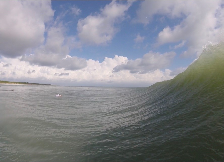
Just got out from an incoming tide session, I think now is the time to go. Definitely closing out, but the faces stay open enough to give you some room. More water is definitely helping
|
|
|
|
|
|
09/07/2021 10:51 AM
|
|
|
|
|
|
|
|
|
09/07/2021 11:02 AM
|
|
|
|
|
|
|
|
|
09/07/2021 02:00 PM
|
|
|
The closeouts are wider than the Surfline camera window
|
|
|
|
|
|
09/07/2021 02:36 PM
|
|
|
It's a solid 6-7 foot 15sec swell on most of the incoming buoys . now it's all about the tide and wind . Pick your spots and bars that can take a 15 sec swell . Know where the edges are
time to use I've got a positive covid test option now , before your buddy does |
|
|
|
|
|
09/07/2021 04:58 PM
|
|
|
time to use I've got a positive covid test option now , before your buddy does Nah, you just say your buddy must of gave it to you |
|
|
|
|
|
09/07/2021 04:36 PM
|
|
|
Just got off the beach fishing - long long long lines, some sets near chest high. More consistency to the sets while I was there. Glassy with no wind.
------------------------- QOP = Terrorists FK = Gay |
|
|
|
|
|
09/07/2021 07:18 PM
|
|
|
I saw a 2 foot set with white water from bicentennial park to pet den. Closeout city south of the cape on these long period swells from the SE. Go to Ponce inlet. Me? I'll wait for a swell out of the north.
|
|
|
|
|
|
09/07/2021 07:39 PM
|
|
|
Not allowed to drive until at least Sept 24.
|
|
|
|
|
|
09/08/2021 06:07 AM
|
|
|
Thanks seaspray, dead high tide right now. Offshore winds until noon'ish. I'm checking it soon.
|
|
|
|
|
|
09/08/2021 06:50 AM
|
|
|
very long closeouts, a few corners, clean enough, hope the wind holds for lower tide...
------------------------- add a signature since I'm here in profile anyway |
|
|
|
|
|
09/08/2021 08:58 AM
|
|
|
Fun enough if you were patient for the right waves. Overall it was slow which is expected with the long period. Lot of bait in the water and spinners everywhere. Got tagged by a nasty jelly on my ankle that most definitively was not a simple moon jelly.
|
|
|
|
|
|
09/08/2021 09:05 AM
|
|
|
Getting bigger this afternoon. Surfed patrick area. of course, mostly close outs, long wait for big sets. Typical forerunners with bad angle and long period swell.
Fun enough though. saw some bikinis, caught a couple waves. Look at wind forecast tomorrow and swell size increase (in theory). Yeah...glad I got a paddle in to warm up. |
|
|
|
|
|
09/08/2021 09:32 AM
|
|
|
Fun morning up here.... alot of peeps will say it sucked because they surfed their usual HT spots.... looked at first light, then doubled in size when I walked over the dune 30 min later with my fish and no leash. Had to be selective but they were out there..... hopefully this is just the beginning
Edited: 09/08/2021 at 09:32 AM by Plan B |
|
|
|
|
|
09/08/2021 10:30 AM
|
|
|
Last night there were 17 sec readings on the buoys. Don't think I've ever seen it that high on a clean groundswell. I'm gonna make a guess that the back side of this swell is gonna be fun. No sneaker sets
|
|
|
|
|
|
09/08/2021 11:35 AM
|
|
|
|
|
|
|
|
|
09/08/2021 12:11 PM
|
|
|
Got in a brief high tide session up in CB, there were a few shoulders for a few secs, nice n glassy for sure at least and easy paddle out. Time to break out the inflatable point break....
|
|
|
|
|
|
09/08/2021 01:08 PM
|
|
|
I got some
------------------------- "The truth is incontrovertible. malice may attack it, ignorance may deride it, but in the end, there it is." -Sir Winston Churchill |
|
|
|
|
|
09/08/2021 03:06 PM
|
|
|
OK, that's one.....
|
|
|
|
|
|
09/08/2021 03:20 PM
|
|
|
I have heard reports that the north side of a inlet, of a north flowing river, near the northern boundary of a NE Fla county was VERY good this am ...... and VERY crowded.
------------------------- "Most people would die sooner than think; in fact, they do." - Bertrand Russell "Morality is doing what is right, regardless of what you are told. Religion is doing what you are told, regardless of what is right. If I do not answer you .... nothing personal, I just have you on ignore. |
|
|
|
|
|
09/08/2021 04:29 PM
|
|
|
LB Larry, thats where I surfed good ol Bill 12 yrs ago
|
|
|
|
|
|
09/09/2021 02:12 AM
|
|
|
Call in a PTO day... then come home from surfing last night to see a tropical storm heading this way with howling offshores and storms forecast
|
|
|
|
|
|
09/09/2021 02:42 AM
|
|
|
|
|
|
|
|
|
09/09/2021 02:44 AM
|
|
|
No bump up on the 20, yet I hope. Was thinking hi tide crumblers vs block long close outs might yeild a few more than yesterday.
------------------------- add a signature since I'm here in profile anyway |
|
|
|
|
|
09/09/2021 03:01 AM
|
|
|
The last spectral density reading from 41009 was at 850Z and the spectral density at the 20 was almost 7 m^2/Hz. That's a fair amount of energy. Wind isn't ideal today. Local pressure gradient should collapse again tomorrow though.
------------------------- ... |
|
|
|
|
|
09/08/2021 03:22 PM
|
|
|
Surfed Cocoa Beach for 6 hours. High tide which is normally good here was awful. 5-6 foot sets breaking way too close to shore and every ride was 5 seconds or less except for one 15 second ride. 3 hours after high tide however some 6-7 foot sets finally started breaking outside. I got stuck in a riptide at one point which worked out because the biggest set of day came in at the perfect time. I couldn't catch the 1st wave but the 2nd one was an 7 or 8 foot bomb that I rode about 400 yards south. The sets were inconsistent but when they did show up it was a blast.
------------------------- Heavy is sign of reliability |
|
|
|
|
|
09/09/2021 04:02 AM
|
|
|
|
|
|
|
|
|
09/09/2021 10:25 AM
|
|
|
Super fun surf this morning.
|
|
|
|
|
|
09/09/2021 11:08 AM
|
|
|
Still long walls were i was..3hrs one good wave
Fingers crossed the angle switches just a hair...
PLEASE...
Waiting to hear what Cole has to say later on....
Wonder what the wind will do...alot of S. on it this morning then rain...and then lighting
|
|
|
|
|
|
09/10/2021 11:23 AM
|
|
|
That was perfect. Offshore. 6-8. Wow.
------------------------- "One of the reasons why propaganda tries to get you to hate government is because it's the one existing institution in which people can participate to some extent and constrain tyrannical unaccountable power." Noam Chomsky. |
|
|
|
|
|
09/10/2021 01:08 PM
|
|
|
|
|
|
09/10/2021 02:04 PM
|
|
|
------------------------- ola ~ |
|
|
|
|
|
09/12/2021 05:25 AM
|
|
|
Never got as big as I hoped, but some really fun surf..... 6 hours a day with sessions before and after work (didnt work too hard
Looking forward to more (and no landfall stress, please)
Edited: 09/12/2021 at 05:31 AM by Plan B |
|
|
|
|
|
09/12/2021 05:43 AM
|
|
|
This is still not registering in the swell models. But it looks very promising.
------------------------- "One of the reasons why propaganda tries to get you to hate government is because it's the one existing institution in which people can participate to some extent and constrain tyrannical unaccountable power." Noam Chomsky. |
|
|
|
|
|
FORUMS
:
Surfing
:
Here comes 12 / Larry?
|
Topic Tools |
FuseTalk Basic Edition - © 1999-2024 FuseTalk Inc. All rights reserved.