
 |
2nd Light Forums |
 |
 |  |


|
Topic Title: Let's get this party started... Topic Summary: 'tis the season... Tropical Storm Erin Created On: 08/11/2025 06:58 AM |
Linear : Threading : Single : Branch |
 |
- Central Floridave | - 08/11/2025 06:58 AM |
|
- Central Floridave | - 08/11/2025 08:17 AM |
|
- Central Floridave | - 08/11/2025 08:19 AM |
|
- Central Floridave | - 08/11/2025 08:23 AM |
|
- tubeTime | - 08/11/2025 08:28 AM |
|
- Central Floridave | - 08/11/2025 08:44 AM |
|
- Wavewatcher | - 08/11/2025 11:07 AM |
|
- eastcoastersrule | - 08/11/2025 12:01 PM |
|
- dingpatch | - 08/11/2025 12:56 PM |
|
- seaspray | - 08/12/2025 03:36 AM |
|
- dingpatch | - 08/12/2025 04:46 AM |
|
- dingpatch | - 08/12/2025 05:05 AM |
|
- Central Floridave | - 08/12/2025 08:02 AM |
|
- Bamboo | - 08/12/2025 10:03 AM |
|
- Cole | - 08/12/2025 11:15 AM |
|
- Plan B | - 08/13/2025 10:44 AM |
|
- Cole | - 08/14/2025 06:30 AM |
|
- eastcoastersrule | - 08/14/2025 06:43 AM |
|
- fishkller | - 08/15/2025 11:51 AM |
|
- Wavewatcher | - 08/12/2025 11:35 AM |
|
- johnnyboy | - 08/12/2025 01:50 PM |
|
- dingpatch | - 08/13/2025 05:00 AM |
|
- Central Floridave | - 08/13/2025 07:09 AM |
|
- Central Floridave | - 08/13/2025 09:37 AM |
|
- Central Floridave | - 08/13/2025 09:44 AM |
|
- dingpatch | - 08/15/2025 04:17 PM |
|
- johnnyboy | - 08/14/2025 08:11 AM |
|
- Bamboo | - 08/14/2025 12:19 PM |
|
- Central Floridave | - 08/14/2025 03:13 PM |
|
- Central Floridave | - 08/15/2025 07:38 AM |
|
- 3rdworldlover | - 08/15/2025 08:26 AM |
|
- Central Floridave | - 08/15/2025 08:42 AM |
|
- Cole | - 08/15/2025 11:41 AM |
|
- 3rdworldlover | - 08/15/2025 12:21 PM |
|
- Central Floridave | - 08/16/2025 05:27 AM |
|
- Central Floridave | - 08/16/2025 05:29 AM |
|
- Wavewatcher | - 08/16/2025 07:31 AM |
|
- Central Floridave | - 08/16/2025 07:34 AM |
|
- dingpatch | - 08/16/2025 08:28 AM |
|
- dingpatch | - 08/16/2025 08:32 AM |
|
- Wavewatcher | - 08/16/2025 09:35 AM |
|
- Bamboo | - 08/16/2025 11:26 AM |
|
- 3rdworldlover | - 08/16/2025 02:20 PM |
|
- Wavewatcher | - 08/17/2025 03:30 AM |
|
- Cole | - 08/17/2025 07:14 AM |
|
- Wavewatcher | - 08/17/2025 07:36 AM |
|
- fishkller | - 08/17/2025 11:29 AM |
|
- Central Floridave | - 08/17/2025 03:26 PM |
|
- fishkller | - 08/17/2025 09:32 PM |
|
- Wavewatcher | - 08/17/2025 11:00 PM |
|
- scostuart | - 08/18/2025 06:02 AM |
|
- Cole | - 08/18/2025 06:11 AM |
|
- fishkller | - 08/18/2025 04:05 PM |
|
- Central Floridave | - 08/18/2025 06:28 AM |
|
- LaJune | - 08/18/2025 06:54 AM |
|
- Central Floridave | - 08/18/2025 06:29 AM |
|
- Central Floridave | - 08/18/2025 06:33 AM |
|
- Central Floridave | - 08/18/2025 06:58 AM |
|
- IamSAW2 | - 08/18/2025 11:26 AM |
|
- Central Floridave | - 08/18/2025 11:44 AM |
|
- tom | - 08/18/2025 12:50 PM |
|
- Wavewatcher | - 08/18/2025 01:21 PM |
|
- eastcoastersrule | - 08/19/2025 12:28 PM |
|
- tom | - 08/19/2025 12:58 PM |
|
- tom | - 08/19/2025 01:10 PM |
|
- Wavewatcher | - 08/19/2025 04:48 PM |
|
- fishkller | - 08/19/2025 05:23 PM |
|
- KP | - 08/18/2025 02:12 PM |
|
- 3rdworldlover | - 08/18/2025 07:04 PM |
|
- waveaddict | - 08/18/2025 08:50 PM |
|
- fishkller | - 08/18/2025 11:48 PM |
|
- tom | - 08/19/2025 03:19 AM |
|
- seaspray | - 08/19/2025 03:31 AM |
|
- Central Floridave | - 08/19/2025 05:06 AM |
|
- Central Floridave | - 08/19/2025 09:35 AM |
|
- johnnyboy | - 08/19/2025 10:52 AM |
|
- dingpatch | - 08/19/2025 12:11 PM |
|
- 3rdworldlover | - 08/19/2025 01:00 PM |
|
- big rick | - 08/19/2025 09:53 PM |
|
- Wavewatcher | - 08/19/2025 11:45 PM |
|
- 3rdworldlover | - 08/20/2025 05:08 AM |
|
- Wavewatcher | - 08/20/2025 04:12 PM |
|
- Central Floridave | - 08/20/2025 05:05 PM |
|
- Wavewatcher | - 08/20/2025 06:33 PM |
|
- tom | - 08/21/2025 03:00 AM |
|
- Cole | - 08/21/2025 04:14 AM |
|
- Cole | - 08/21/2025 06:02 AM |
|
- Cole | - 08/21/2025 10:00 AM |
|
- paddleout | - 08/21/2025 10:17 AM |
|
- IamSAW2 | - 08/21/2025 11:43 AM |
|
- Wavewatcher | - 08/21/2025 02:43 PM |
|
- mp2115 | - 08/22/2025 12:41 AM |
|
- tom | - 08/22/2025 02:56 AM |
|
- paddleout | - 08/22/2025 07:55 PM |
|
- scombrid | - 08/23/2025 03:37 AM |
|
- Cole | - 08/23/2025 06:49 AM |
|
- Bamboo | - 08/23/2025 09:30 AM |
|
- Cole | - 08/23/2025 11:56 AM |
|
- meaty | - 08/23/2025 12:57 PM |
|
- rose_surfer | - 08/23/2025 02:32 PM |
|
- Cole | - 08/23/2025 05:03 PM |
|
- meaty | - 08/24/2025 07:24 AM |
|
- Cole | - 08/24/2025 10:33 AM |
|
- Central Floridave | - 08/22/2025 04:51 AM |
|
- IamSAW2 | - 08/22/2025 08:35 AM |
|
- Cole | - 08/22/2025 08:42 AM |
|
- johnnyboy | - 08/22/2025 09:39 AM |
|
- Wavewatcher | - 08/22/2025 10:17 AM |
|
- Central Floridave | - 08/22/2025 10:26 AM |
|
- meaty | - 08/22/2025 12:42 PM |
|
- Central Floridave | - 08/22/2025 05:39 PM |
|
- KP | - 08/25/2025 04:26 AM |
|
- Central Floridave | - 08/23/2025 06:33 AM |
|
- Central Floridave | - 08/24/2025 09:03 AM |
|
- 3rdworldlover | - 08/24/2025 12:19 PM |
|
- Cole | - 08/24/2025 03:50 PM |
|
- Central Floridave | - 08/25/2025 06:41 PM |
|
- mp2115 | - 08/26/2025 07:10 AM |
|
- Central Floridave | - 08/29/2025 12:44 PM |
|
- Cole | - 08/30/2025 08:55 AM |
|
- Cole | - 09/01/2025 11:33 AM |
|
- mp2115 | - 09/02/2025 12:21 AM |
|
- tom | - 09/03/2025 07:35 PM |
|
- Wavewatcher | - 09/03/2025 09:15 PM |
|
- tom | - 09/04/2025 03:26 AM |
 Topic Tools Topic Tools
|

 08/11/2025 06:58 AM 08/11/2025 06:58 AM


|
|
|
First day of school is today, Monday (Aug11). Football season nears as well. Gawd I love this time of year. Of course this latest blob on NHC discussion has caused an uproar on the long range tracking the past week. Between model runs it is bouncing all over the place and it is not even a named storm yet. But, that is gonna change.
We see this every time this year. One huge cape verde storm roars across that Atlantic and then the entire ocean blows it's lid and all of a sudden we have 4 or 5 named storms. Bottom line, models of course are just that, models. Simulations on what is predicted by math models and such. We all know they are off in the long range but they seem to be getting better at predicting thru the years. This one that the NHC labels AL97 is gonna keep the surf forecasters on their toes and we lowly surfers guessing when it will hit. For me, when I see a big spike in surf heights a week out, I up my pool lab count and get my house and yard in order for a possible hurricane strike. You don't want to be getting your belongings ready when it nears as you should be surfing. Just preaching to the choir. ... 'tis the season....Let's get this party started! Eastern Tropical Atlantic (AL97): Shower and thunderstorm activity has persisted and continues to show signs of organization with a well-defined area of low pressure located just to the west of the Cabo Verde Islands. If these structural trends continue, the system is likely to become a tropical depression or storm, possibly as soon as later this morning. Locally heavy rainfall and gusty winds are expected to continue today across portions of the Cabo Verde Islands, and interests there should monitor the progress of this system. Regardless of development over the next couple of days, the system is expected to continue moving westward to west-northwestward at 15 to 20 mph across the eastern and central tropical Atlantic. * Formation chance through 48 hours...high...90 percent. * Formation chance through 7 days...high...90 percent. Edited: 08/11/2025 at 08:18 AM by Central Floridave |
|
|
|
|
|
08/11/2025 08:17 AM
|
|
|
They named it for the 2pm today.
BULLETIN Tropical Storm Erin Advisory Number 1 NWS National Hurricane Center Miami FL AL052025 200 PM CVT Mon Aug 11 2025 ...TROPICAL STORM ERIN FORMS JUST WEST OF THE CABO VERDE ISLANDS... SUMMARY OF 200 PM CVT...1500 UTC...INFORMATION ---------------------------------------------- LOCATION...17.4N 28.0W ABOUT 280 MI...455 KM WNW OF THE CABO VERDE ISLANDS ABOUT 2305 MI...3710 KM E OF THE NORTHERN LEEWARD ISLANDS MAXIMUM SUSTAINED WINDS...45 MPH...75 KM/H PRESENT MOVEMENT...W OR 275 DEGREES AT 20 MPH...31 KM/H MINIMUM CENTRAL PRESSURE...1004 MB...29.65 INCHES WATCHES AND WARNINGS -------------------- There are no coastal watches or warnings in effect. DISCUSSION AND OUTLOOK ---------------------- At 200 PM CVT (1500 UTC), the center of Tropical Storm Erin was located near latitude 17.4 North, longitude 28.0 West. Erin is moving toward the west near 20 mph (31 km/h), and this motion is expected to continue for the next several days. Earlier satellite wind data indicated that maximum sustained winds are near 45 mph (75 km/h) with higher gusts. Gradual strengthening is forecast over the next several days. Tropical-storm-force winds extend outward up to 35 miles (55 km) from the center. The estimated minimum central pressure is 1004 mb (29.65 inches). HAZARDS AFFECTING LAND ---------------------- None. NEXT ADVISORY ------------- Next complete advisory at 800 PM CVT. |
|
|
|
|
|
08/11/2025 08:19 AM
|
|
|
Tropical Storm Erin Discussion Number 1
NWS National Hurricane Center Miami FL AL052025 200 PM CVT Mon Aug 11 2025 The system we have been monitoring that moved across the Cabo Verde Islands over the past 6-12 h (Invest 97L) has maintained a small, but persistent area of deep convection. This activity prompted an earlier TAFB subjective Dvorak fix of T2.5/35 kt suggesting the convection is now sufficently organized to be classified as a tropical cyclone. We also received scatterometer data at 1107 UTC with a peak wind retrieval of 39 kt embedded in this convection, with an ambiguity analysis suggesting the circulation is also well defined, albeit still somewhat elongated on the eastern edge. The combination of all this data suggests that a tropical storm has formed, and NHC is initiating advisories on Tropical Storm Erin with a current intensity of 40 kt. Erin is moving quickly off to the west, with the motion estimated at 275/17 kt. Over the next few days, this motion should continue with possibly some slight south-of-due-west motion. Erin's motion is primarily influenced by an east-to-west oriented mid-level ridge draped across the subtropical Atlantic basin. By the end of the forecast period, this ridge may start to become more oriented to the northeast of Erin, inducing a more poleward motion by 120 h. The initial NHC track forecast elects to stick fairly close to the HFIP corrected consensus approach (HCCA), which is a touch on the south side of the overall track guidance envelope. It should be noted that spread in the track guidance, especially the ensembles, begins to increase markedly at the end of the forecast period. The intensity forecast in the short-term is a little tricky. The earlier scatterometer data indicate the system has a small circulation which could be prone to rapid intensity changes, either up or down. While vertical wind shear over the system is forecast to be low, between 5-10 kt over the next 72 hours, sea-surface temperatures are more marginal, around 26-27C, with a decent amount of dry mid-level air along the path of the tropical storm. The first NHC intensity forecast will thus only forecast slow intensification in the short-term, assuming the marginal SSTs and lack of mid-level moisture will keep the small vortex in check. After 48 h, however, the SSTs start to gradually increase and should allow the local environment of Erin to moisten up. Thus, the rate of intensification will likely increase in the second half of the forecast period. The NHC intensity forecast is a little on the high side of the guidance in the short-term, partially due to the initial intensity, but is in line with the HCCA intensity aid. By 120 h, the hurricane-regional models (e.g., HWRF/HAFS), and statistical-dynamical aids (EC-SHIPS/LGEM) show Erin becoming a major hurricane, and that will be explicitly forecast at the end of the period. FORECAST POSITIONS AND MAX WINDS INIT 11/1500Z 17.4N 28.0W 40 KT 45 MPH 12H 12/0000Z 17.5N 31.2W 45 KT 50 MPH 24H 12/1200Z 17.4N 35.1W 50 KT 60 MPH 36H 13/0000Z 17.1N 38.7W 55 KT 65 MPH 48H 13/1200Z 17.1N 41.7W 60 KT 70 MPH 60H 14/0000Z 17.4N 45.0W 70 KT 80 MPH 72H 14/1200Z 18.0N 48.4W 80 KT 90 MPH 96H 15/1200Z 19.6N 54.0W 90 KT 105 MPH 120H 16/1200Z 21.5N 60.0W 100 KT 115 MPH |
|
|
|
|
|
08/11/2025 08:23 AM
|
|
|
I was a little confused on CVT being used, explaination:
CVT usually refers to Cape Verde Time, which is the time zone used in Cape Verde (an island country off the coast of West Africa). Offset: CVT is UTC - 1 (1 hour behind Coordinated Universal Time). No daylight saving time - CVT stays the same year-round. Example: If it's 12:00 noon UTC, it's 11:00 AM CVT. Cape Verde Time (CVT) is 4 hours ahead of Eastern Standard Time (EST). So: 2:00 PM CVT ? 10:00 AM EST |
|
|
|
|
|
08/11/2025 08:28 AM
|
|
|
I'm ready to party! What's the guestimate on the swell showing up? Could we see waves even before the weekend?

I'd guess frontrunners should show up by Sat/Sun. I have not looked at wave models since FNMOC took their site away from the public. |
|
|
|
|
|
08/11/2025 08:44 AM
|
|
|
virtual buoy shows 14-16 seconds on the 17th/18th. Of course subject to change! Looking at Erin right now looks borderllne T.S now. NHC must have named it to kick in the hype-R-drive.
|
|
|
|
|
|
08/11/2025 11:07 AM
|
|
|
Surfline and Surf-forecast, after backing down on the Erin Swell, have juiced it up with substantial wave energy. Monday-Tuesday.
------------------------- wavewatcher - >ww - >wavewatcher, again |
|
|
|
|
|
08/11/2025 12:01 PM
|
|
|
Hatteras should start showing the swell over the weekend
|
|
|
|
|
|
08/11/2025 12:56 PM
|
|
|
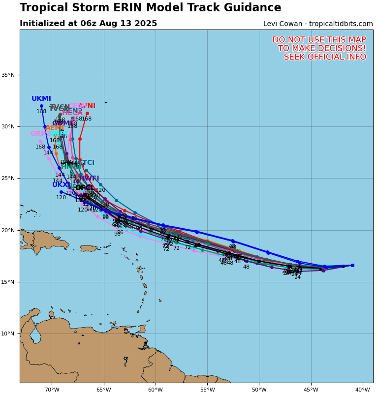
The end of this rteaxk puts it North of PR and East of Ft Lauderdale. Looks like the 'sweet' spot, if it maintains 'major'.
Erin ------------------------- Dora Hates You Edited: 08/11/2025 at 12:57 PM by dingpatch |
|
|
|
|
|
08/12/2025 03:36 AM
|
|
|
going to be a fun wavemaker
|
|
|
|
|
|
08/12/2025 04:46 AM
|
|
|
Models this morning look a little-bit more west?
But still, looks to be a Major pumping straight at us for a dew days. ------------------------- Dora Hates You |
|
|
|
|
|
08/12/2025 05:05 AM
|
|
|
A tropical storm is just a "rain with a name".
------------------------- Dora Hates You |
|
|
|
|
|
08/12/2025 08:02 AM
|
|
|
I like what I see on the recurving North of Puerto Rico and on the swell period models. NHC reports this morning that Erin is still a minimal tropical storm. Looks to stay that way as it moves West, then balloon up some NE of Puerto Rico, then recurve North. Knock on wood. Swimming a 1/4 mile today in the pool. Aug 18th maybe some 16 second forerunners...aka...close out city swell...then wait for the swell angle to flip from the NE later in the week. Knock on wood.
|
|
|
|
|
|
08/12/2025 10:03 AM
|
|
|
This looks to be a good swell maker and right now looks to stay offshore.
As a reminder, Tropical Tidbits has good detailed info on Atlantic storms. https://www.youtube.com/watch?v=uoHCwh0uyng Pray for surf! 
------------------------- If I should ever die, God forbid, let this be my epitaph: THE ONLY PROOF HE NEEDED FOR THE EXISTENCE OF GOD WAS MUSIC - KV |
|
|
|
|
|
08/12/2025 11:15 AM
|
|
|
Two days of eight foot closed out walls.
Let's hope the wind cooperates the 3 hours that it's good. ------------------------- I was right. |
|
|
|
|
|
08/13/2025 10:44 AM
|
|
|
|
|
|
|
|
|
08/14/2025 06:30 AM
|
|
|
Two days of eight foot closed out walls. . There always has to be THAT guy.... I will update in real time to keep an accurate measure. And yes, I hope I am wrong, but reality is on my side. If it's a Cat 1 or less, we are good. If it's a 2 or beyond, my prediction will be spot on. Way north Brevard? That might be a different story, but you better have your paddle arms prepared. ------------------------- I was right. Edited: 08/14/2025 at 06:32 AM by Cole |
|
|
|
|
|
08/14/2025 06:43 AM
|
|
|
There's only a few spots that can handle size:
Monster Hole and Reef Road are two of them
|
|
|
|
|
|
08/15/2025 11:51 AM
|
|
|
Two days of eight foot closed out walls. Let's hope the wind cooperates the 3 hours that it's good. ^^^ This. Ill be waiting for the back end of it ------------------------- 
We have certain things in common Jeffrey.. |
|
|
|
|
|
08/12/2025 11:35 AM
|
|
|
Tues. afternoon, Surf-Forecast continues with wildly high wave energy for Rodanthe and S-Turns
------------------------- wavewatcher - >ww - >wavewatcher, again |
|
|
|
|
|
08/12/2025 01:50 PM
|
|
|
South Florida boys. PM me and we can talk.
------------------------- "One of the reasons why propaganda tries to get you to hate government is because it's the one existing institution in which people can participate to some extent and constrain tyrannical unaccountable power." Noam Chomsky. |
|
|
|
|
|
08/13/2025 05:00 AM
|
|
------------------------- Dora Hates You |
|
|
|
|
|
08/13/2025 07:09 AM
|
|
|
Google Gemini Surf Forecast:
What is the surf forecast for Satellite Beach Florida? Surf in Satellite Beach, Florida, is expected to be small over the next few days, with wave heights generally in the 1-2 foot range. Winds will be from the south and southeast, creating choppy to semi-clean conditions. A significant change in the forecast is anticipated for the beginning of next week due to a developing tropical disturbance, likely Tropical Storm Erin. Models are showing this storm could generate well-overhead surf with a longer period (around 12 seconds) for early to mid-next week. However, the exact timing and size of the swell will depend on the storm's track. Here is a more detailed breakdown: Today (Wednesday, August 13): Waves are around 1-2 feet. Thursday, August 14 - Saturday, August 16: Surf is expected to drop off to around 1 foot. Sunday, August 17: There is a possibility of a small swell showing up later in the day, with waves potentially reaching 1-3 feet. Next Week: The most significant surf is forecast for the beginning of next week, with some models calling for well-overhead waves. As always, surf conditions can change, and it is best to check a local surf report or buoy data for the most up-to-the-minute information. Given the potential for a tropical system to impact the area, surfers should monitor the National Hurricane Center and local weather advisories closely. |
|
|
|
|
|
08/13/2025 09:37 AM
|
|
|
Swam 1/4 mile yesterday and now stepping it up to 1/2 mile a day swim for the next couple of days. Maybe some surf this weekend (knock on wood) but the juice looks to arrive next week. period swell models pushed back to late Monday/Tuesday for forerunners.
Tropical Storm Erin Discussion Number 9 NWS National Hurricane Center Miami FL AL052025 1100 AM AST Wed Aug 13 2025 Erin continues to have a ragged overall appearance, with one burst of convection just southwest of the center and skeletal convective bands elsewhere in the northwestern semicircle. Various subjective and objective satellite intensity estimates are in the 30-45 kt range, and these have changed little over the past several hours. A just-received scatterometer overpass shows winds near 40 kt just north of the center, and based on these data the initial intensity is held at 40 kt. Erin continues to struggle to intensify, likely due to its track over persistent sea surface temperatures of 26-27C and entrainment of dry and stable air. The forecast track keeps the system over these marginal SSTs for another 24 h or so, followed by a motion over increasing SSTs that reach 29-30C by the end of the forecast period. The cyclone is currently in a favorable low- to moderate-shear environment, and this is likely to continue for the next 72 h. This evolution should allow Erin to significantly intensify, with the cyclone forecast to become a hurricane by 48 h and a major hurricane by 96 hr. After 72-96 h, Erin may encounter increased northerly shear as it tracks to the northeast of a large upper-level anticyclone forecast to form near Hispaniola and the southeastern Bahamas. Although the strength of shear the cyclone will encounter is uncertain, the intensity guidance suggests a lower rate of intensification at that time. The new intensity forecast is little changed from the previous forecast and is in best agreement with the intensity consensus. The initial motion is now 265/15 kt. While a strong low- to mid-level ridge currently is situated to the north of Erin, in a day or two a slight weakness is forecast to develop in this ridge near 65W longitude. This should cause the tropical cyclone to turn west-northwestward after 24 h, with some decrease in forward speed after 72 h. After 96 h, a developing break in the ridge near the southeastern coast of the United States should lead to a northwestward motion. The track guidance is in fairly good agreement, and the official forecast on the southern side of the guidance envelope between the HCCA corrected consensus and the other consensus models. The new track is similar to the previous track through 72 h and a little west of the previous track thereafter. Users are reminded that NHC track forecasts have an average error of 150 to 215 miles at days 4 and 5, and future adjustments to the forecast are still possible. KEY MESSAGES: 1. Erin could move close enough to the northern Leeward Islands, the Virgin Islands, and Puerto Rico over the weekend to produce some impacts on those islands. However, the magnitude of those impacts is still not known, and interests there should continue to monitor the progress of this storm. 2. There is even greater uncertainty in what impacts might occur in portions of the Greater Antilles, the Bahamas, the east coast of the United States, and Bermuda next week. As we approach the climatological peak of the hurricane season, this is an opportune time to ensure your preparedness plans are in place. FORECAST POSITIONS AND MAX WINDS INIT 13/1500Z 16.3N 43.4W 40 KT 45 MPH 12H 14/0000Z 16.3N 45.6W 45 KT 50 MPH 24H 14/1200Z 16.6N 48.6W 50 KT 60 MPH 36H 15/0000Z 17.4N 51.5W 55 KT 65 MPH 48H 15/1200Z 18.2N 54.3W 65 KT 75 MPH 60H 16/0000Z 19.0N 57.2W 75 KT 85 MPH 72H 16/1200Z 19.9N 60.0W 85 KT 100 MPH 96H 17/1200Z 21.7N 64.6W 100 KT 115 MPH 120H 18/1200Z 23.9N 67.3W 105 KT 120 MPH $$ Forecaster Beven |
|
|
|
|
|
08/13/2025 09:44 AM
|
|
|
The waiting is the hardest part...
|
|
|
|
|
|
08/15/2025 04:17 PM
|
|
|
>>>> Speaking to Newsweek, Jean-Raymond Bidlot, senior scientist in ocean modeling at the European Centre for Medium-Range Weather Forecasts (ECMWF), said: "The latest forecast does indeed indicate that the largest significant wave height could reach values in excess of 50 feet with an associated most likely largest wave of more than 100 feet."
That's...absurd. Of course, 100-footers aren't going to be hitting New Smyrna Beach, up to the Outer Banks, and beyond. But there will be swell, that's for sure. <<<< ------------------------- Dora Hates You |
|
|
|
|
|
08/14/2025 08:11 AM
|
|
|
That paddle at monster hole stays with you. Same with the many men in the gray suits that pop by early and often.
------------------------- "One of the reasons why propaganda tries to get you to hate government is because it's the one existing institution in which people can participate to some extent and constrain tyrannical unaccountable power." Noam Chomsky. |
|
|
|
|
|
08/14/2025 12:19 PM
|
|
|
Agreed that if it is a cat 2+ and a few hundred miles out there will be times of massive 500 yard close outs at most of our popular spots.
But there should be windows when it is good, like when the first swells hit....or after it has passed to our north and we get the favorable angle and maybe good winds. The 20 mile spectral density chart is a fav indicator. When the frequency gets less than .1 Hz, and the graph cleans up into a single defined peak...that can be some really good surf. https://www.ndbc.noaa.gov/show...=41009&meas=spec&uom=E If you surf, you gotta be an optimist!
------------------------- If I should ever die, God forbid, let this be my epitaph: THE ONLY PROOF HE NEEDED FOR THE EXISTENCE OF GOD WAS MUSIC - KV |
|
|
|
|
|
08/14/2025 03:13 PM
|
|
|
I don't think I'll ever surf monster hole again but I did surf it tons in the 80s/90s when I was much younger and in great shape. I'd pay you 5 bucks now for a sea-doo to out and even more important IN.
Wow, there were times trying to paddle in was way harder than out. I'm really looking forward to next week's swell. Good or bad, close out or not. Last week's swell was a good warm up 4me. I put a ding in my board, gotta fix that. The waiting is....the hardest part.... |
|
|
|
|
|
08/15/2025 07:38 AM
|
|
|
marine forecast coming in focus for next week. Local wind forecast is of course not accurate, but mucky winds forecast for now. There are small waves today (Friday) 1-2 feet. Looks longboardable.
SUNDAY Southeast winds around 5 knots, becoming northeast in the afternoon. Seas 2 feet. Wave Detail: East 2 feet at 9 seconds. MONDAY Northeast winds 5 to 10 knots. Seas 3 to 4 feet. A light chop on the intracoastal waters. A chance of showers and thunderstorms. TUESDAY North winds 10 to 15 knots. Seas 4 to 5 feet, occasionally to 6 feet. A moderate chop on the intracoastal waters. A chance of showers and thunderstorms. |
|
|
|
|
|
08/15/2025 08:26 AM
|
|
|
GFS has stiff NNE winds Tuesday and Wednesday during the peak.
It's also predicting a major storm hitting just north of the cape following week, around the 28th. Edited: 08/15/2025 at 09:31 AM by 3rdworldlover |
|
|
|
|
|
08/15/2025 08:42 AM
|
|
|
Hurricane Erin Discussion Number 17
NWS National Hurricane Center Miami FL AL052025 1100 AM AST Fri Aug 15 2025 Erin has become better organized during the past several hours. The last few NOAA and Air Force Reserve aircraft passes through the cyclone have indicated the formation of an eyewall, with the Air Force Reserve aircraft reporting 700-mb flight-level winds of 75 kt northeast of the center. In addition, conventional satellite imagery shows the development of a central dense overcast, and a recently received WSFM microwave overpass shows a well-defined ring of shallow to moderate convection in the 37 GHz imagery. Based on these data, the initial intensity is increased to 65 kt and Erin becomes the first hurricane of the 2025 Atlantic Hurricane Season. The initial motion is 290/15. The subtropical ridge to the north will continue to steer Erin west-northwestward into the weekend. Encroaching mid-latitude westerly flow is forecast to cause a weakness to develop in the ridge during the latter part of the forecast period, and this will result in the hurricane gradually turning northwestward and northward by 120 h. The guidance remains in fairly good agreement through about 60-72 hours. After that time, there are some differences in both the forward speed and cross-track spread with the turn toward the north. The regional hurricane models again lie along the western edge of the guidance envelope, while the GFS and Google DeepMind models remain on the eastern edge. Although still spread, the guidance envelope has not shifted significantly since the last advisory, and the new track forecast is an update of the previous forecast. There is still uncertainty about what impacts Erin may bring to portions of the Bahamas, the east coast of the United States, and Bermuda in the long range. Erin is currently in a favorable environment for strengthening, although there are some uncertainties on whether dry air is entraining into the core. The improved low-level structure indicates potential for rapid strengthening, and based on this the first 36-48 h of the new intensity forecast shows a faster development rate. After 48 h, the hurricane is forecast to encounter some northerly to northwesterly vertical shear that should at least slow development. However, the global and regional hurricane models are in good agreement that Erin will become a powerful and increasingly large hurricane over the southwestern Atlantic over the weekend and into next week. It should be noted that the the Florida State SuperEnsemble and the US Navy COAMPS-TC models forecast higher peak intensities than the official forecast, so it would not be too surprising if Erin became stronger than currently forecast. KEY MESSAGES: 1. Heavy rainfall tonight through Sunday across the northern Leeward Islands, the Virgin Islands, and Puerto Rico may lead to isolated and locally considerable flash and urban flooding, along with landslides or mudslides. 2. Tropical storm conditions are possible for portions of the northern Leeward Islands, where Tropical Storm Watches are in effect, beginning on Saturday as the core of Erin passes north of those islands. Gusts to tropical storm force are possible in rainbands over portions of the Virgin Islands and Puerto Rico later in the weekend. 3. While the threat of direct impacts in the Bahamas and along the east coast of the United States appears to be gradually decreasing, there will still be a significant risk of dangerous surf and rip currents along western Atlantic beaches next week. 4. Interests in Bermuda should continue to monitor the progress of Erin since there is still a risk of strong winds, heavy rainfall, and high surf by the middle part of next week. FORECAST POSITIONS AND MAX WINDS INIT 15/1500Z 18.2N 56.1W 65 KT 75 MPH 12H 16/0000Z 18.9N 58.4W 75 KT 85 MPH 24H 16/1200Z 19.8N 61.4W 90 KT 105 MPH 36H 17/0000Z 20.6N 63.8W 105 KT 120 MPH 48H 17/1200Z 21.6N 66.0W 110 KT 125 MPH 60H 18/0000Z 22.7N 67.9W 115 KT 130 MPH 72H 18/1200Z 23.8N 69.2W 120 KT 140 MPH 96H 19/1200Z 26.5N 70.8W 115 KT 130 MPH 120H 20/1200Z 30.3N 71.0W 110 KT 125 MPH $$ Forecaster Beven |
|
|
|
|
|
08/15/2025 11:41 AM
|
|
|
Why is the wind ripping out of the North East if the storm is too far out to influence our weather?
------------------------- I was right. |
|
|
|
|
|
08/15/2025 12:21 PM
|
|
|
A high pressure frontal boundary pushes off the SE coast, keeping the storm from hitting us.
You can thank the democrat weather control machines and chemtrails |
|
|
|
|
|
08/16/2025 05:27 AM
|
|
|
For cat 5 hurricane floyd the 120 mile buoy read 56 feet before it got ripped off it's mooring.
|
|
|
|
|
|
08/16/2025 05:29 AM
|
|
|
Hurricane Erin Discussion Number 20
NWS National Hurricane Center Miami FL AL052025 500 AM AST Sat Aug 16 2025 Erin is rapidly strengthening and is now a category 3 major hurricane. Satellite images indicate that Erin has a small eye and a compact and symmetric inner core. The hurricane has also been maintaining a large area of deep convection to the southwest of the core, and those outer rainbands are affecting the northern Leeward Islands. The Air Force Hurricane Hunters departed Erin a few hours ago, but on their last couple of passes through the center, the minimum pressure was steadily falling. Since the structure of the system has notably improved over the past few hours, the initial intensity is increased to 105 kt, and that could be conservative. Both the NOAA and Air Force Hurricane Hunters will be investigating Erin again later this morning, and that wealth of data will be very helpful in evaluating the cyclone's intensity and structure. The system continues to move fairly quickly to the west-northwest at about 17 kt on the south side of a subtropical ridge. This overall motion should continue through the weekend, taking the core of Erin to the north of the eastern Caribbean Islands through Sunday. After that time, the western side of the ridge is expected to weaken, due to a series of shortwave troughs, and that should cause Erin to slow down and make a gradual turn to the north. The models agree on this general theme, but there are some differences on where, when, and how sharply Erin makes the northward turn. The NHC track forecast is a touch to the left of the previous one to be in better agreement with the latest consensus aids. Confidence continues to increase that the core of Erin will pass to the east of the Bahamas and the United States. Erin is expected to continue to rapidly strengthen over the next 12 hours while it remains in favorable conditions of warm water, low wind shear, and in an environment of high moisture. Erin will likely become a Category 4 hurricane later today and strengthening could continue through tonight. By early next week, however, an increase in shear should end the strengthening trend and induce gradual weakening. The NHC intensity forecast lies above the guidance for the first 24 to 36 hours, and then falls near the middle of the guidance envelope after that. Although Erin is a somewhat compact hurricane now, the models are in strong agreement that the system will grow in size over the next several days. In fact, by the middle of next week, Erin is forecast to at least double or triple in size, which will result in rough ocean conditions over the western Atlantic. KEY MESSAGES: 1. Heavy rainfall at times through Sunday across the northern Leeward Islands, the Virgin Islands, and Puerto Rico may lead to locally considerable flash and urban flooding, along with landslides or mudslides. 2. Gusts to tropical storm force in Erin's outer rainbands are possible in portions of the the northern Leeward Islands later today and over portions of the Virgin Islands and Puerto Rico tonight and Sunday. 3. Erin is expected to produce dangerous surf and rip currents along the beaches of the Bahamas, much of the east coast of the U.S., and Atlantic Canada next week. 4. Interests in Bermuda should continue to monitor the progress of Erin since there is a risk of strong winds, heavy rainfall, and high surf by the middle part of next week. FORECAST POSITIONS AND MAX WINDS INIT 16/0900Z 19.8N 61.1W 105 KT 120 MPH 12H 16/1800Z 20.3N 63.3W 130 KT 150 MPH 24H 17/0600Z 21.1N 65.6W 130 KT 150 MPH 36H 17/1800Z 22.1N 67.5W 125 KT 145 MPH 48H 18/0600Z 23.3N 68.8W 120 KT 140 MPH 60H 18/1800Z 24.6N 69.8W 115 KT 130 MPH 72H 19/0600Z 26.2N 70.5W 110 KT 125 MPH 96H 20/0600Z 29.9N 70.9W 105 KT 120 MPH 120H 21/0600Z 34.7N 68.0W 95 KT 110 MPH $$ |
|
|
|
|
|
08/16/2025 07:31 AM
|
|
------------------------- wavewatcher - >ww - >wavewatcher, again |
|
|
|
|
|
08/16/2025 07:34 AM
|
|
|
Hurricane Erin Advisory Number 21
NWS National Hurricane Center Miami FL AL052025 1100 AM AST Sat Aug 16 2025 ...CATEGORY 4 ERIN STILL RAPIDLY INTENSIFYING... ...OUTER RAINBANDS AFFECTING THE NORTHERN LEEWARD ISLANDS... SUMMARY OF 1100 AM AST...1500 UTC...INFORMATION ----------------------------------------------- LOCATION...19.7N 62.8W ABOUT 105 MI...170 KM N OF ANGUILLA ABOUT 235 MI...375 KM ENE OF SAN JUAN PUERTO RICO MAXIMUM SUSTAINED WINDS...155 MPH...250 KM/H PRESENT MOVEMENT...W OR 280 DEGREES AT 17 MPH...28 KM/H MINIMUM CENTRAL PRESSURE...923 MB...27.26 INCHES |
|
|
|
|
|
08/16/2025 08:28 AM
|
|
|
From Central Florida Hurricane: Erin may now be a Category 5 hurricane, having undergone completely unforecast Rapid Intensification (RI) overnight, unforeseen by almost all models. However, one Global kept hinting that RI sooner than later ~ along with a more westward track overall ~ was a possibility (ICON).
It is safe to say that there are now some wrinkles in Erin's forecast. Once every so often a hurricane goes wildly off-script. Erin is already there having become this strong, this fast, and tracking south of forecast for eight hours or so now. Forecasts for Erin's strength and importantly track should be taken with a little less certainty this morning, and interests from the Northern Leeward Islands to the east coast of the United States, perhaps particularly the OBX, may want to begin paying much closer attention. This is a potentially very dangerous hurricane. Ciel ...AIR FORCE RESERVE HURRICANE HUNTERS FIND ERIN IS NOW A CATASTROPHIC CATEGORY 5 HURRICANE... ------------------------- Dora Hates You Edited: 08/16/2025 at 08:30 AM by dingpatch |
|
|
|
|
|
08/16/2025 08:32 AM
|
|
|
Gonna need some CAT 5 wax!
But, I fly to Nashville Tuesday afternoon ------------------------- Dora Hates You |
|
|
|
|
|
08/16/2025 09:35 AM
|
|
|
11 am from the NHC has forecast for cat 5 status.
------------------------- wavewatcher - >ww - >wavewatcher, again |
|
|
|
|
|
08/16/2025 11:26 AM
|
|
|
Dang, that escalated quickly....
------------------------- If I should ever die, God forbid, let this be my epitaph: THE ONLY PROOF HE NEEDED FOR THE EXISTENCE OF GOD WAS MUSIC - KV |
|
|
|
|
|
08/16/2025 02:20 PM
|
|
|
Rapid intensification is the new norm it seems
|
|
|
|
|
|
08/17/2025 03:30 AM
|
|
------------------------- wavewatcher - >ww - >wavewatcher, again |
|
|
|
|
|
08/17/2025 07:14 AM
|
|
|
I've read that 100 foot waves/swells aren't uncommon in the large storms. We just don't have an accurate way of measuring them. There needs to be a transducer on the ocean floor to get an accurate reading, but getting it in the right place is nearly impossible.
If it remains a Cat 5 through our window, I will upgrade my prediction to 12 foot closed out walls with the Satellite Beach walkways taking another beating. ------------------------- I was right. |
|
|
|
|
|
08/17/2025 07:36 AM
|
|
|
Erin might already be past its max winds. Windy's GFS animation has already moved the late Aug landfall west to Louisiana. Quite a jump.
------------------------- wavewatcher - >ww - >wavewatcher, again |
|
|
|
|
|
08/17/2025 11:29 AM
|
|
|
Yeah, as far as the next one after Erin, GFS has it beaning New Orleans on 8/28 while the Euro has it turning north in the Atlantic and dissipating quite a disparity.. one to watch for sure -------------------------
We have certain things in common Jeffrey.. |
|
|
|
|
|
08/17/2025 03:26 PM
|
|
|
The waiting is the hardest part! Meanwhile, check this one on sunday eve. INCOMMING...
Station 41047 - NE BAHAMAS - 350 NM ENE of Nassau, Bahamas 7 feet 13 seconds. ESE. |
|
|
|
|
|
08/17/2025 09:32 PM
|
|
|
Well this is fugly..
GFS Wed 8/27 Euro has it out to sea, so let's hope the GFS starts to conform to the Euro 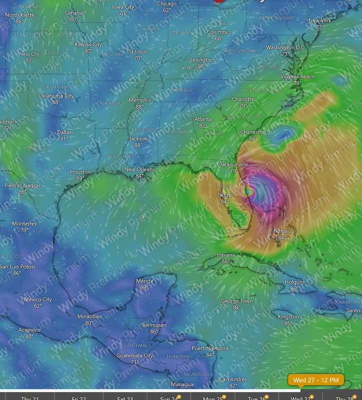
-------------------------
We have certain things in common Jeffrey.. |
|
|
|
|
|
08/17/2025 11:00 PM
|
|
------------------------- wavewatcher - >ww - >wavewatcher, again Edited: 08/18/2025 at 05:22 AM by Wavewatcher |
|
|
|
|
|
08/18/2025 06:02 AM
|
|
|
------------------------- Waiting for waves is ok......most people spend their lives waiting for nothing. |
|
|
|
|
|
08/18/2025 06:11 AM
|
|
|
Station 41047, aka the Bahamas buoy - 15.4 at 14 seconds
The walls are a comin. ------------------------- I was right. |
|
|
|
|
|
08/18/2025 04:05 PM
|
|
|
....10 days out..........lol Nice catch Captain Obvious. Now point out we're on the internet too LOL -------------------------
We have certain things in common Jeffrey.. Edited: 08/18/2025 at 05:39 PM by fishkller |
|
|
|
|
|
08/18/2025 06:28 AM
|
|
|
wowsa, 16 feet at 14 seconds....3rd reef pipe will be breaking.
|
|
|
|
|
|
08/18/2025 06:54 AM
|
|
|
The party has commenced! 3ft @ 12 sec on the 20m. It started yesterday though. 4-5ft sneaker sets were showing up in the afternoon in Cocoa Beach.
------------------------- Heavy is sign of reliability |
|
|
|
|
|
08/18/2025 06:29 AM
|
|
|
it's wierd, the nearshore buoy already shows 14 seconds from the ESE this Monday morning, yet the 20 mile buoy doesn't. That buoy's algorhythm must be filtering it out. But, it's coming.
|
|
|
|
|
|
08/18/2025 06:33 AM
|
|
|
Monday morning marine forecast and looking at local winds:
REST OF TODAY Northeast winds 5 to 10 knots. Seas 3 to 4 feet. Wave Detail: East 3 feet at 14 seconds and northeast 2 feet at 9 seconds. TUESDAY North winds 10 to 15 knots. Seas 6 to 8 feet, occasionally to 10 feet. Wave Detail: East 7 feet at 16 seconds. WEDNESDAY North winds 10 to 15 knots. Seas 8 to 10 feet, occasionally to 13 feet. Wave Detail: East 10 feet at 15 seconds and east 6 feet at 7 seconds. THURSDAY Northwest winds 5 to 10 knots, becoming northeast in the afternoon. Seas 7 to 9 feet, occasionally to 11 feet. FRIDAY Northwest winds around 5 knots, becoming east in the afternoon. Seas 5 to 6 feet, occasionally to 8 feet. Smooth on the intracoastal waters. |
|
|
|
|
|
08/18/2025 06:58 AM
|
|
|
thnks. going out soon this monday morning. Looks glassy still for now, but that's gonna change.
|
|
|
|
|
|
08/18/2025 11:26 AM
|
|
|
Mid morn Munday near Highcrowder some chest plus sets with shoulders, the larger ones were pretty walled out. Managed to get a few, blind squirrel strategy. Wind was initially light onshore, was cranking up when i left around 1pm. Lotsa turtles. Nice warm up sesh, but prob will be watching from the beach for a few days...
|
|
|
|
|
|
08/18/2025 11:44 AM
|
|
|
4 feet 13 ticks East swell on 20 miler 2pm Monday. It's all chopped out this afternoon though.
Surf at 2ndlight this morning was barely rideble. 2-3 feet and glassy. Hoping we get a glass off the next few mornings. But, whatev, back in it. Warm up sesh for sure. Hope the cane season party last thru November. Also, hoping they all stay offshore. |
|
|
|
|
08/18/2025 12:50 PM

|
|
|
Mandatory evacuation of Hatteras? Sheesh.
------------------------- add a signature since I'm here in profile anyway |
|
|
|
|
|
08/18/2025 01:21 PM
|
|
|
The road from Buxton to Rodanthe and even north of there has become increasingly tenuous, despite the bridge at the last temporary inlet. Erin is projected
------------------------- wavewatcher - >ww - >wavewatcher, again |
|
|
|
|
|
08/19/2025 12:28 PM
|
|
|
|
|
|
|
|
|
08/19/2025 12:58 PM
|
|
|
^Too many tourists to support when 12 washes out. And the you've got to ferry them off. Locals aren't going anywhere, same as always.
------------------------- add a signature since I'm here in profile anyway |
|
|
|
|
|
08/19/2025 01:10 PM
|
|
|
I think in Dare county, mandatory evac closes all short term/vacation rentals. Private residence are as 3rd says, same as here.
------------------------- add a signature since I'm here in profile anyway |
|
|
|
|
|
08/19/2025 04:48 PM
|
|
|
The evacuation order is for Hatteras and Ocracoke, not for anywhere farther north. Part of the concern is that Erin has become an enormous storm. Surfline had a comment on its total energy--a measure that I think meteorologists use fairly often to compare storms. The deal is that a vast but relatively low-wind storm can be far larger in energy terms than a small but intense one. Charley of 2004 was a specimen of that.
------------------------- wavewatcher - >ww - >wavewatcher, again |
|
|
|
|
|
08/19/2025 05:23 PM
|
|
|
"Although the season's first Atlantic hurricane is expected to stay offshore, evacuations were ordered on barrier islands along the Carolina coast as authorities warned the storm could churn up dangerous rip currents." The fascist government officials are out of control! People now are evacuated because of dangerous rip currents? Why? Can you imagine if everytime there were "dangerous rip currents" tourits and locals would have to evacuate Thanks Obama! -------------------------
We have certain things in common Jeffrey.. |
|
|
|
|
|
08/18/2025 02:12 PM
|
|
|
Swell is coming in along with the wind. Solid shoulder high with push behind it. Bummer that the tide is high and making it break close to shore in a lot of places. PAFB was rideable with 1 or 2 snap to backwash/closeout.
------------------------- Time and tide wait for no one..... |
|
|
|
|
|
08/18/2025 07:04 PM
|
|
|
Some squeezed through the bahamas and we got overhead surf in palm beach county this evening
|
|
|
|
|
|
08/18/2025 08:50 PM
|
|
|
Thursday ??????
------------------------- Think and seek and you shall find..... |
|
|
|
|
|
08/18/2025 11:48 PM
|
|
|
RE: the storm after Erin , the GFS model has now moved closer to the Euro, and more out to sea- neither one shows landfall now, so... nice. -------------------------
We have certain things in common Jeffrey.. |
|
|
|
|
|
08/19/2025 03:19 AM
|
|
|
Now there's one behind the one behind Erin.
------------------------- add a signature since I'm here in profile anyway |
|
|
|
|
|
08/19/2025 03:31 AM
|
|
|
This is when I visit the Kiddie Pool
|
|
|
|
|
|
08/19/2025 05:06 AM
|
|
|
Tuesday: 20 mile buoy 10 feet 16 seconds. Onshore winds Tuesday. Day of rest for me. I watched a jettypark cam for a little bit. It's big up there as well and bad form/shape. But, it's big!
Volusia-Brevard County Line to Sebastian Inlet 0-20 nm 238 AM EDT Tue Aug 19 2025 SMALL CRAFT ADVISORY IN EFFECT THROUGH THURSDAY EVENING TODAY Northeast winds 10 to 15 knots. Seas 4 to 6 feet, occasionally to 8 feet, building to 6 to 8 feet, occasionally to 10 feet. Wave Detail: East 6 feet at 16 seconds, becoming east 7 feet at 16 seconds this afternoon. A moderate chop on the intracoastal waters. A chance of showers with a slight chance of thunderstorms. WEDNESDAY North winds 15 to 20 knots. Seas 10 to 12 feet, occasionally to 15 feet. Wave Detail: East 10 feet at 15 seconds. Choppy on the intracoastal waters. A chance of showers. A slight chance of thunderstorms in the morning, then a chance of thunderstorms in the afternoon. THURSDAY West winds 5 to 10 knots, becoming southwest in the afternoon. Seas 7 to 9 feet, occasionally to 11 feet. Wave Detail: Northeast 9 feet at 13 seconds. A light chop on the intracoastal waters. A slight chance of showers and thunderstorms in the morning, then showers and thunderstorms likely in the afternoon. FRIDAY Northwest winds 5 to 10 knots, becoming east in the afternoon. Seas 5 to 6 feet, occasionally to 8 feet. A light chop on the intracoastal waters. A chance of showers and thunderstorms in the morning, then showers and thunderstorms likely in the afternoon. FRIDAY NIGHT Southwest winds around 5 knots, becoming west after midnight. Seas 5 to 7 feet, occasionally to 9 feet. Smooth on the intracoastal waters. Showers likely with a chance of thunderstorms in the evening, then a chance of showers with a slight chance of thunderstorms after midnight. SATURDAY West winds around 5 knots, becoming southeast in the afternoon. Seas 5 to 6 feet, occasionally to 8 feet. A light chop on the intracoastal waters. A chance of showers and thunderstorms in the morning, then showers and thunderstorms likely in the afternoon. |
|
|
|
|
|
08/19/2025 09:35 AM
|
|
|
Tuesday afternoon, 20 mile buoy 10 feet 16 seconds! Give or take in size. Wind howling from the N to NE. Chopped out.
|
|
|
|
|
|
08/19/2025 10:52 AM
|
|
|
Blown out and small for now. Last night Palm Beach got the slot.
------------------------- "One of the reasons why propaganda tries to get you to hate government is because it's the one existing institution in which people can participate to some extent and constrain tyrannical unaccountable power." Noam Chomsky. |
|
|
|
|
|
08/19/2025 12:11 PM
|
|
------------------------- Dora Hates You |
|
|
|
|
|
08/19/2025 01:00 PM
|
|
|
Mandatory evacuation only applies to a specific portion of the outer banks that's expected to experience storm surge and large swells causing overwash and road flooding and damage making it inaccessible to emergency responders. You can stay if you want but don't call 911.
|
|
|
|
|
|
08/19/2025 09:53 PM
|
|
|
Heard Cherie Down was on point this morning
Pictures? I was calling for Jetty Park, personally ------------------------- hey, i don't know if you read this yet ----------> I <3 16streets.com thank you Sean O'hare Delicious beer comes from here |
|
|
|
|
|
08/19/2025 11:45 PM
|
|
|
Currituck County, NC has (late in the game) ordered evacuation of the four-wheel-drive access beach area around Corolla, north of Dare County.
------------------------- wavewatcher - >ww - >wavewatcher, again |
|
|
|
|
|
08/20/2025 05:08 AM
|
|
|
A friend just sent a pic of jetty park, looks fun but not very significant swell.
|
|
|
|
|
|
08/20/2025 04:12 PM
|
|
|
This evening, high tide, Vero South Beach was doing its classic glassy close-out shorebreak. Not very big, but capable of squishing.
------------------------- wavewatcher - >ww - >wavewatcher, again |
|
|
|
|
|
08/20/2025 05:05 PM
|
|
|
NOW the party starts!
THURSDAY West winds 5 to 10 knots, becoming south in the afternoon. Seas 5 to 7 feet, occasionally to 9 feet. Wave Detail: Northeast 7 feet at 12 seconds and southeast 2 feet at 5 seconds. A light chop on the intracoastal waters. Showers and thunderstorms likely in the afternoon. FRIDAY West winds 5 to 10 knots, becoming south in the afternoon. Seas 4 to 5 feet, occasionally to 6 feet. Wave Detail: Northeast 5 feet at 12 seconds and southeast 2 feet at 5 seconds. A light chop on the intracoastal waters. A chance of showers and thunderstorms in the morning, then showers and thunderstorms likely in the afternoon. SATURDAY West winds 5 to 10 knots, becoming south in the afternoon. Seas 4 to 5 feet, occasionally to 6 feet. Wave Detail: Northeast 4 feet at 13 seconds and southeast 2 feet at 5 seconds. A light chop on the intracoastal waters. A chance of showers and thunderstorms in the morning, then showers and thunderstorms likely in the afternoon. SUNDAY Southwest winds 5 to 10 knots. Seas 4 to 5 feet, occasionally to 6 feet. A light chop on the intracoastal waters. A chance of showers and thunderstorms in the morning, then showers and thunderstorms likely in the afternoon. MONDAY Southwest winds 5 to 10 knots. Seas 3 to 4 feet. A light chop on the intracoastal waters. A chance of showers and thunderstorms in the morning, then showers and thunderstorms likely in the afternoon. |
|
|
|
|
|
08/20/2025 06:33 PM
|
|
|
It looks like good conditions are moving southward.
------------------------- wavewatcher - >ww - >wavewatcher, again |
|
|
|
|
|
08/21/2025 03:00 AM
|
|
|
41009: WSW@10, 8ft, 11sec, 6am.
------------------------- add a signature since I'm here in profile anyway |
|
|
|
|
|
08/21/2025 04:14 AM
|
|
|
41009: WSW@10, 8ft, 11sec, 6am. Here is our four hours. ------------------------- I was right. |
|
|
|
|
|
08/21/2025 06:02 AM
|
|
|
Looks fun. Head high plus with a northerly tilt. Wind is puffing from the West.
------------------------- I was right. |
|
|
|
|
|
08/21/2025 10:00 AM
|
|
|
I'm too old for four hours in summertime heat. Long, long rides.
------------------------- I was right. |
|
|
|
|
|
08/21/2025 10:17 AM
|
|

|
|
|
|
|
|
08/21/2025 11:43 AM
|
|
|
That was worth waiting for, im absolutely spent. So many peeling glassy peaks. Looking fwd to rinse and repeat fri.
|
|
|
|
|
|
08/21/2025 02:43 PM
|
|
|
I never noticed that Norfolk Island pine.
------------------------- wavewatcher - >ww - >wavewatcher, again |
|
|
|
|
|
08/22/2025 12:41 AM
|
|
|
Surfed a spot just too the south, what a great day! Surf vacation in the back yard.

|
|
|
|
|
|
08/22/2025 02:56 AM
|
|
|
Dang, nice pic! Kinda makes you remember why we live here.
------------------------- add a signature since I'm here in profile anyway |
|
|
|
|
|
08/22/2025 07:55 PM
|
|
|
Dang, nice pic! Kinda makes you remember why we live here. The pic isn't mine, I believe Catalyst posted that on their Instagram or something. It was shore slam city tonight at sunset. big walls crashing down hard into like a foot of sand. high tide. |
|
|
|
|
|
08/23/2025 03:37 AM
|
|
|
So yesterday as Erin transitioned from tropical to non-tropical the wind fields were spectacular. Consequently the south Hatteras buoy graph shows 15 m^2/Hz at 15, 13, and 12 seconds this morning with energy at 14. Area under the curve says that's a lot of juice with a NNE direction. Today should be interesting.
------------------------- ... |
|
|
|
|
|
08/23/2025 06:49 AM
|
|
|
So yesterday as Erin transitioned from tropical to non-tropical the wind fields were spectacular. Consequently the south Hatteras buoy graph shows 15 m^2/Hz at 15, 13, and 12 seconds this morning with energy at 14. Area under the curve says that's a lot of juice with a NNE direction. Today should be interesting. Interesting stuff for sure. I've never seen any tropical system provide this much swell when it's on a northern trajectory. The swell period is increasing, too. Five feet at 15 seconds. We have moved into numbers more common in the Pacific. ------------------------- I was right. |
|
|
|
|
|
08/23/2025 09:30 AM
|
|
|
Hurricane Dennis in 1999 had a sorta similar path and it was the gift that just kept giving.
i wanna say I surfed for 7+ straight days and it was fantastic. The North tilt of the swell gave us some great lefts. 
------------------------- If I should ever die, God forbid, let this be my epitaph: THE ONLY PROOF HE NEEDED FOR THE EXISTENCE OF GOD WAS MUSIC - KV |
|
|
|
|
|
08/23/2025 11:56 AM
|
|
|
Gordon was another one.
We happened to be sitting in the line-up at the Light when the swell refreshed. There were some of the longest rides I've ever had in Florida; from the flag pole to the second walkway without a single piece of water out of place. ------------------------- I was right. |
|
|
|
|
|
08/23/2025 12:57 PM
|
|
|
Went out this am in sat be not great lotsa morning sickness.
My 11 year old had a blast tho, so idgaf
|
|
|
|
|
|
08/23/2025 02:32 PM
|
|
|
Got good in the streets after the storms passed, right around low. A bit of a wait between sets. A little smaller and mellower but more fun than the closeout session in satellite this morning.
|
|
|
|
|
|
08/23/2025 05:03 PM
|
|
|
It dropped like the proverbial rock before dark. We got cleaned on the outside during the paddle out, then ended up catching the shore break as the sun set.
------------------------- I was right. Edited: 08/24/2025 at 07:35 AM by Cole |
|
|
|
|
|
08/24/2025 07:24 AM
|
|
|
Canova dp strong sideshore winds chopping it up. canova still hollow as fuck
|
|
|
|
|
|
08/24/2025 10:33 AM
|
|
|
I think the sensor on the buoy is jammed. There ain't no way it's 5.6 at 13.
------------------------- I was right. |
|
|
|
|
|
08/22/2025 04:51 AM
|
|
|
More surf this Friday! Get it.
|
|
|
|
|
|
08/22/2025 08:35 AM
|
|
|
Big long left bombs this morn, super fun.
|
|
|
|
|
|
08/22/2025 08:42 AM
|
|
|
Different swell angle in the hood today. It's the same size but less makeable.
------------------------- I was right. |
|
|
|
|
|
08/22/2025 09:39 AM
|
|
|
Fair amount of closeouts in the overhead range. Found a great shoulder that opened up and would have gotten a hollow stand up tube if I had the presence of mind to stall instead of racing ahead of what I thought was a closeout. It was so big and clean I rode a log. That was a good choice until I got stuck on the inside and unfortunately denied. That took it all out of me too.
------------------------- "One of the reasons why propaganda tries to get you to hate government is because it's the one existing institution in which people can participate to some extent and constrain tyrannical unaccountable power." Noam Chomsky. |
|
|
|
|
|
08/22/2025 10:17 AM
|
|
|
Wabasso lunchtime had long-period characteristics, the waves having more energy than local wind waves of the same size. Got home barely ahead of a shower.
------------------------- wavewatcher - >ww - >wavewatcher, again |
|
|
|
|
|
08/22/2025 10:26 AM
|
|
|
Friday, bigger and better in Satellite. Wowsa. Storms hit around 12:30pm.
|
|
|
|
|
|
08/22/2025 12:42 PM
|
|
|
4-6 in mel beach this am. Shifty with significant S drift, but scored some absolute bombs. Breaking really slow and ez to get in and down the line before it closed.
Fun times
|
|
|
|
|
|
08/22/2025 05:39 PM
|
|
|
My contribution to the many videos out there.
|
|
|
|
|
|
08/25/2025 04:26 AM
|
|
|
Nice vid Dave!:
------------------------- Time and tide wait for no one..... Edited: 08/25/2025 at 04:27 AM by KP |
|
|
|
|
|
08/23/2025 06:33 AM
|
|
|
More for Saturday...waiting for the tide to drop this morning! Coffee taste great at the moment.
I imagine it's going to be overly crowded today....Thus, here comes the obligatory....SPREAD OUT PEOPLE... |
|
|
|
|
|
08/24/2025 09:03 AM
|
|
|
yup, another day, sunday. More surf! Woot!
|
|
|
|
|
|
08/24/2025 12:19 PM
|
|
|
Sets were still well overhead this morning in northern palm beach county
|
|
|
|
|
|
08/24/2025 03:50 PM
|
|
|
Sets were still well overhead this morning in northern palm beach county Ah, the 20 miler is getting skimmed and SFL is getting the goods. There is still size here, but it pretty much sucks unless you have some secret spot. ------------------------- I was right. Edited: 08/24/2025 at 03:50 PM by Cole |
|
|
|
|
|
08/25/2025 06:41 PM
|
|
|
Thank!
I got to surf hangars this Monday afternoon. Still long period with some size! Amazing run. 7 days so far. Hoping for 8. |
|
|
|
|
|
08/26/2025 07:10 AM
|
|
|
What a great swell bender. I already miss it but thankful for the waves in the back yard!
Edited: 08/26/2025 at 07:11 AM by mp2115 |
|
|
|
|
|
08/29/2025 12:44 PM
|
|
|
Somebody put another quarter in the swell machine. thnx.
|
|
|
|
|
|
08/30/2025 08:55 AM
|
|
|
Somebody put another quarter in the swell machine. thnx. We were told it would be a never ending swell nirvana after the first one. BOO! ------------------------- I was right. |
|
|
|
|
|
09/01/2025 11:33 AM
|
|
|
Clean chest high bowls with no one out. I love random swells.
------------------------- I was right. |
|
|
|
|
|
09/02/2025 12:21 AM
|
|
|
|
|
|
|
|
|
09/03/2025 07:35 PM
|
|
|
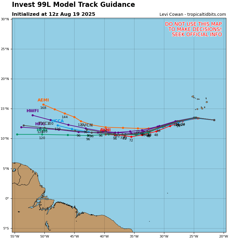
Early GFS run for Gabrielle shows a brush with Hatteras. Stay tuned.
------------------------- add a signature since I'm here in profile anyway |
|
|
|
|
|
09/03/2025 09:15 PM
|
|
|
Next model run for Gabrielle might send it to Houston. That happened with Erin.
------------------------- wavewatcher - >ww - >wavewatcher, again |
|
|
|
|
|
09/04/2025 03:26 AM
|
|
|
Houston we have a problem! (Tom Hanks)
------------------------- add a signature since I'm here in profile anyway |
|
|
|
|
|
FORUMS
:
Surfing
:
Let's get this party started...
|
Topic Tools |
FuseTalk Basic Edition - © 1999-2025 FuseTalk Inc. All rights reserved.