
 |
2nd Light Forums |
 |
 |  |


|
Topic Title: Let's get this party started... Topic Summary: 'tis the season... Tropical Storm Erin Created On: 08/11/2025 06:58 AM |
Linear : Threading : Single : Branch |
|
 Topic Tools Topic Tools
|

 08/11/2025 06:58 AM 08/11/2025 06:58 AM


|
|
|
First day of school is today, Monday (Aug11). Football season nears as well. Gawd I love this time of year. Of course this latest blob on NHC discussion has caused an uproar on the long range tracking the past week. Between model runs it is bouncing all over the place and it is not even a named storm yet. But, that is gonna change.
We see this every time this year. One huge cape verde storm roars across that Atlantic and then the entire ocean blows it's lid and all of a sudden we have 4 or 5 named storms. Bottom line, models of course are just that, models. Simulations on what is predicted by math models and such. We all know they are off in the long range but they seem to be getting better at predicting thru the years. This one that the NHC labels AL97 is gonna keep the surf forecasters on their toes and we lowly surfers guessing when it will hit. For me, when I see a big spike in surf heights a week out, I up my pool lab count and get my house and yard in order for a possible hurricane strike. You don't want to be getting your belongings ready when it nears as you should be surfing. Just preaching to the choir. ... 'tis the season....Let's get this party started! Eastern Tropical Atlantic (AL97): Shower and thunderstorm activity has persisted and continues to show signs of organization with a well-defined area of low pressure located just to the west of the Cabo Verde Islands. If these structural trends continue, the system is likely to become a tropical depression or storm, possibly as soon as later this morning. Locally heavy rainfall and gusty winds are expected to continue today across portions of the Cabo Verde Islands, and interests there should monitor the progress of this system. Regardless of development over the next couple of days, the system is expected to continue moving westward to west-northwestward at 15 to 20 mph across the eastern and central tropical Atlantic. * Formation chance through 48 hours...high...90 percent. * Formation chance through 7 days...high...90 percent. Edited: 08/11/2025 at 08:18 AM by Central Floridave |
|
|
|
|
|
08/11/2025 08:17 AM
|
|
|
They named it for the 2pm today.
BULLETIN Tropical Storm Erin Advisory Number 1 NWS National Hurricane Center Miami FL AL052025 200 PM CVT Mon Aug 11 2025 ...TROPICAL STORM ERIN FORMS JUST WEST OF THE CABO VERDE ISLANDS... SUMMARY OF 200 PM CVT...1500 UTC...INFORMATION ---------------------------------------------- LOCATION...17.4N 28.0W ABOUT 280 MI...455 KM WNW OF THE CABO VERDE ISLANDS ABOUT 2305 MI...3710 KM E OF THE NORTHERN LEEWARD ISLANDS MAXIMUM SUSTAINED WINDS...45 MPH...75 KM/H PRESENT MOVEMENT...W OR 275 DEGREES AT 20 MPH...31 KM/H MINIMUM CENTRAL PRESSURE...1004 MB...29.65 INCHES WATCHES AND WARNINGS -------------------- There are no coastal watches or warnings in effect. DISCUSSION AND OUTLOOK ---------------------- At 200 PM CVT (1500 UTC), the center of Tropical Storm Erin was located near latitude 17.4 North, longitude 28.0 West. Erin is moving toward the west near 20 mph (31 km/h), and this motion is expected to continue for the next several days. Earlier satellite wind data indicated that maximum sustained winds are near 45 mph (75 km/h) with higher gusts. Gradual strengthening is forecast over the next several days. Tropical-storm-force winds extend outward up to 35 miles (55 km) from the center. The estimated minimum central pressure is 1004 mb (29.65 inches). HAZARDS AFFECTING LAND ---------------------- None. NEXT ADVISORY ------------- Next complete advisory at 800 PM CVT. |
|
|
|
|
|
08/11/2025 08:19 AM
|
|
|
Tropical Storm Erin Discussion Number 1
NWS National Hurricane Center Miami FL AL052025 200 PM CVT Mon Aug 11 2025 The system we have been monitoring that moved across the Cabo Verde Islands over the past 6-12 h (Invest 97L) has maintained a small, but persistent area of deep convection. This activity prompted an earlier TAFB subjective Dvorak fix of T2.5/35 kt suggesting the convection is now sufficently organized to be classified as a tropical cyclone. We also received scatterometer data at 1107 UTC with a peak wind retrieval of 39 kt embedded in this convection, with an ambiguity analysis suggesting the circulation is also well defined, albeit still somewhat elongated on the eastern edge. The combination of all this data suggests that a tropical storm has formed, and NHC is initiating advisories on Tropical Storm Erin with a current intensity of 40 kt. Erin is moving quickly off to the west, with the motion estimated at 275/17 kt. Over the next few days, this motion should continue with possibly some slight south-of-due-west motion. Erin's motion is primarily influenced by an east-to-west oriented mid-level ridge draped across the subtropical Atlantic basin. By the end of the forecast period, this ridge may start to become more oriented to the northeast of Erin, inducing a more poleward motion by 120 h. The initial NHC track forecast elects to stick fairly close to the HFIP corrected consensus approach (HCCA), which is a touch on the south side of the overall track guidance envelope. It should be noted that spread in the track guidance, especially the ensembles, begins to increase markedly at the end of the forecast period. The intensity forecast in the short-term is a little tricky. The earlier scatterometer data indicate the system has a small circulation which could be prone to rapid intensity changes, either up or down. While vertical wind shear over the system is forecast to be low, between 5-10 kt over the next 72 hours, sea-surface temperatures are more marginal, around 26-27C, with a decent amount of dry mid-level air along the path of the tropical storm. The first NHC intensity forecast will thus only forecast slow intensification in the short-term, assuming the marginal SSTs and lack of mid-level moisture will keep the small vortex in check. After 48 h, however, the SSTs start to gradually increase and should allow the local environment of Erin to moisten up. Thus, the rate of intensification will likely increase in the second half of the forecast period. The NHC intensity forecast is a little on the high side of the guidance in the short-term, partially due to the initial intensity, but is in line with the HCCA intensity aid. By 120 h, the hurricane-regional models (e.g., HWRF/HAFS), and statistical-dynamical aids (EC-SHIPS/LGEM) show Erin becoming a major hurricane, and that will be explicitly forecast at the end of the period. FORECAST POSITIONS AND MAX WINDS INIT 11/1500Z 17.4N 28.0W 40 KT 45 MPH 12H 12/0000Z 17.5N 31.2W 45 KT 50 MPH 24H 12/1200Z 17.4N 35.1W 50 KT 60 MPH 36H 13/0000Z 17.1N 38.7W 55 KT 65 MPH 48H 13/1200Z 17.1N 41.7W 60 KT 70 MPH 60H 14/0000Z 17.4N 45.0W 70 KT 80 MPH 72H 14/1200Z 18.0N 48.4W 80 KT 90 MPH 96H 15/1200Z 19.6N 54.0W 90 KT 105 MPH 120H 16/1200Z 21.5N 60.0W 100 KT 115 MPH |
|
|
|
|
|
08/11/2025 08:23 AM
|
|
|
I was a little confused on CVT being used, explaination:
CVT usually refers to Cape Verde Time, which is the time zone used in Cape Verde (an island country off the coast of West Africa). Offset: CVT is UTC - 1 (1 hour behind Coordinated Universal Time). No daylight saving time - CVT stays the same year-round. Example: If it's 12:00 noon UTC, it's 11:00 AM CVT. Cape Verde Time (CVT) is 4 hours ahead of Eastern Standard Time (EST). So: 2:00 PM CVT ? 10:00 AM EST |
|
|
|
|
|
08/11/2025 08:28 AM
|
|
|
I'm ready to party! What's the guestimate on the swell showing up? Could we see waves even before the weekend?

I'd guess frontrunners should show up by Sat/Sun. I have not looked at wave models since FNMOC took their site away from the public. |
|
|
|
|
|
08/11/2025 08:44 AM
|
|
|
virtual buoy shows 14-16 seconds on the 17th/18th. Of course subject to change! Looking at Erin right now looks borderllne T.S now. NHC must have named it to kick in the hype-R-drive.
|
|
|
|
|
|
08/11/2025 11:07 AM
|
|
|
Surfline and Surf-forecast, after backing down on the Erin Swell, have juiced it up with substantial wave energy. Monday-Tuesday.
------------------------- wavewatcher - >ww - >wavewatcher, again |
|
|
|
|
|
08/11/2025 12:01 PM
|
|
|
Hatteras should start showing the swell over the weekend
|
|
|
|
|
|
08/11/2025 12:56 PM
|
|
|
The end of this rteaxk puts it North of PR and East of Ft Lauderdale. Looks like the 'sweet' spot, if it maintains 'major'.
Erin ------------------------- Dora Hates You Edited: 08/11/2025 at 12:57 PM by dingpatch |
|
|
|
|
|
08/12/2025 03:36 AM
|
|
|
going to be a fun wavemaker
|
|
|
|
|
|
08/12/2025 04:46 AM
|
|
|
Models this morning look a little-bit more west?
But still, looks to be a Major pumping straight at us for a dew days. ------------------------- Dora Hates You |
|
|
|
|
|
08/12/2025 05:05 AM
|
|
|
A tropical storm is just a "rain with a name".
------------------------- Dora Hates You |
|
|
|
|
|
08/12/2025 08:02 AM
|
|
|
I like what I see on the recurving North of Puerto Rico and on the swell period models. NHC reports this morning that Erin is still a minimal tropical storm. Looks to stay that way as it moves West, then balloon up some NE of Puerto Rico, then recurve North. Knock on wood. Swimming a 1/4 mile today in the pool. Aug 18th maybe some 16 second forerunners...aka...close out city swell...then wait for the swell angle to flip from the NE later in the week. Knock on wood.
|
|
|
|
|
|
08/12/2025 10:03 AM
|
|
|
This looks to be a good swell maker and right now looks to stay offshore.
As a reminder, Tropical Tidbits has good detailed info on Atlantic storms. https://www.youtube.com/watch?v=uoHCwh0uyng Pray for surf! 
------------------------- If I should ever die, God forbid, let this be my epitaph: THE ONLY PROOF HE NEEDED FOR THE EXISTENCE OF GOD WAS MUSIC - KV |
|
|
|
|
|
08/12/2025 11:15 AM
|
|
|
Two days of eight foot closed out walls.
Let's hope the wind cooperates the 3 hours that it's good. ------------------------- I was right. |
|
|
|
|
|
08/12/2025 11:35 AM
|
|
|
Tues. afternoon, Surf-Forecast continues with wildly high wave energy for Rodanthe and S-Turns
------------------------- wavewatcher - >ww - >wavewatcher, again |
|
|
|
|
|
08/12/2025 01:50 PM
|
|
|
South Florida boys. PM me and we can talk.
------------------------- "One of the reasons why propaganda tries to get you to hate government is because it's the one existing institution in which people can participate to some extent and constrain tyrannical unaccountable power." Noam Chomsky. |
|
|
|
|
|
08/13/2025 05:00 AM
|
|
------------------------- Dora Hates You |
|
|
|
|
|
08/13/2025 07:09 AM
|
|
|
Google Gemini Surf Forecast:
What is the surf forecast for Satellite Beach Florida? Surf in Satellite Beach, Florida, is expected to be small over the next few days, with wave heights generally in the 1-2 foot range. Winds will be from the south and southeast, creating choppy to semi-clean conditions. A significant change in the forecast is anticipated for the beginning of next week due to a developing tropical disturbance, likely Tropical Storm Erin. Models are showing this storm could generate well-overhead surf with a longer period (around 12 seconds) for early to mid-next week. However, the exact timing and size of the swell will depend on the storm's track. Here is a more detailed breakdown: Today (Wednesday, August 13): Waves are around 1-2 feet. Thursday, August 14 - Saturday, August 16: Surf is expected to drop off to around 1 foot. Sunday, August 17: There is a possibility of a small swell showing up later in the day, with waves potentially reaching 1-3 feet. Next Week: The most significant surf is forecast for the beginning of next week, with some models calling for well-overhead waves. As always, surf conditions can change, and it is best to check a local surf report or buoy data for the most up-to-the-minute information. Given the potential for a tropical system to impact the area, surfers should monitor the National Hurricane Center and local weather advisories closely. |
|
|
|
|
|
08/13/2025 09:37 AM
|
|
|
Swam 1/4 mile yesterday and now stepping it up to 1/2 mile a day swim for the next couple of days. Maybe some surf this weekend (knock on wood) but the juice looks to arrive next week. period swell models pushed back to late Monday/Tuesday for forerunners.
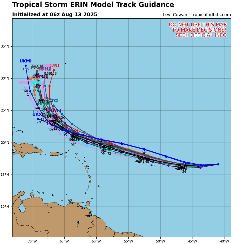
Tropical Storm Erin Discussion Number 9 NWS National Hurricane Center Miami FL AL052025 1100 AM AST Wed Aug 13 2025 Erin continues to have a ragged overall appearance, with one burst of convection just southwest of the center and skeletal convective bands elsewhere in the northwestern semicircle. Various subjective and objective satellite intensity estimates are in the 30-45 kt range, and these have changed little over the past several hours. A just-received scatterometer overpass shows winds near 40 kt just north of the center, and based on these data the initial intensity is held at 40 kt. Erin continues to struggle to intensify, likely due to its track over persistent sea surface temperatures of 26-27C and entrainment of dry and stable air. The forecast track keeps the system over these marginal SSTs for another 24 h or so, followed by a motion over increasing SSTs that reach 29-30C by the end of the forecast period. The cyclone is currently in a favorable low- to moderate-shear environment, and this is likely to continue for the next 72 h. This evolution should allow Erin to significantly intensify, with the cyclone forecast to become a hurricane by 48 h and a major hurricane by 96 hr. After 72-96 h, Erin may encounter increased northerly shear as it tracks to the northeast of a large upper-level anticyclone forecast to form near Hispaniola and the southeastern Bahamas. Although the strength of shear the cyclone will encounter is uncertain, the intensity guidance suggests a lower rate of intensification at that time. The new intensity forecast is little changed from the previous forecast and is in best agreement with the intensity consensus. The initial motion is now 265/15 kt. While a strong low- to mid-level ridge currently is situated to the north of Erin, in a day or two a slight weakness is forecast to develop in this ridge near 65W longitude. This should cause the tropical cyclone to turn west-northwestward after 24 h, with some decrease in forward speed after 72 h. After 96 h, a developing break in the ridge near the southeastern coast of the United States should lead to a northwestward motion. The track guidance is in fairly good agreement, and the official forecast on the southern side of the guidance envelope between the HCCA corrected consensus and the other consensus models. The new track is similar to the previous track through 72 h and a little west of the previous track thereafter. Users are reminded that NHC track forecasts have an average error of 150 to 215 miles at days 4 and 5, and future adjustments to the forecast are still possible. KEY MESSAGES: 1. Erin could move close enough to the northern Leeward Islands, the Virgin Islands, and Puerto Rico over the weekend to produce some impacts on those islands. However, the magnitude of those impacts is still not known, and interests there should continue to monitor the progress of this storm. 2. There is even greater uncertainty in what impacts might occur in portions of the Greater Antilles, the Bahamas, the east coast of the United States, and Bermuda next week. As we approach the climatological peak of the hurricane season, this is an opportune time to ensure your preparedness plans are in place. FORECAST POSITIONS AND MAX WINDS INIT 13/1500Z 16.3N 43.4W 40 KT 45 MPH 12H 14/0000Z 16.3N 45.6W 45 KT 50 MPH 24H 14/1200Z 16.6N 48.6W 50 KT 60 MPH 36H 15/0000Z 17.4N 51.5W 55 KT 65 MPH 48H 15/1200Z 18.2N 54.3W 65 KT 75 MPH 60H 16/0000Z 19.0N 57.2W 75 KT 85 MPH 72H 16/1200Z 19.9N 60.0W 85 KT 100 MPH 96H 17/1200Z 21.7N 64.6W 100 KT 115 MPH 120H 18/1200Z 23.9N 67.3W 105 KT 120 MPH $$ Forecaster Beven |
|
|
|
|
FORUMS
:
Surfing
:
Let's get this party started...
|
Topic Tools |
FuseTalk Basic Edition - © 1999-2025 FuseTalk Inc. All rights reserved.